
ad-Dumair
|
الضمير / aḍ-Ḍumair ad-Dumair |
|||
|---|---|---|---|
|
|||
| Coordinates | 33 ° 39 ′ N , 36 ° 41 ′ E | ||
| Basic data | |||
| Country | Syria | ||
| Rif Dimashq | |||
| ISO 3166-2 | SY-RD | ||
| District | Duma District | ||
| height | 675 m | ||
| Residents | 30,000 (2005) | ||
 View over the old town; the open spaces are planted with olive trees.
|
|||

Ad-Dumair , also Dmeir ( Arabic الضمير Dumayr , DMG aḍ-Ḍumair ), is a small town in the Duma district within the Rif Dimashq governoratein southwest Syria . One of the best-preserved buildings in the country from Roman times stands here .
location
Ad-Dumair is located in the southern part of the Syrian desert steppe, 40 kilometers east of Damascus on the road to Palmyra and Iraq . Agriculture is only possible to a limited extent with artificial irrigation in oases and is limited to olive trees and grain cultivation. The water is supplied by deep wells and, to a lesser extent, by qanats , which secured the water supply as early as Roman times. The place is located on the eastern edge of the settlement zone of central Syria and has therefore had a role since Roman times for goods that were exchanged between the urban merchants from Damascus and the nomadic Bedouins of the eastern Syrian desert. Ad-Dumair was important as the last major station for the supply of water on the Roman road to the Palmyra oasis and on via Resafa to the Euphrates .
history
Under the restored Roman temple in the city center was an altar of the Semitic god Baalshamin , dated 94 BC. It is dated and probably belonged to a temple of the Nabataeans . The Roman temple was built during intensive construction work in the 3rd century AD. It is dedicated to Zeus Hypsistus, a post-classical form of the cult of Zeus in Asia Minor.
Al-Mundhir III ibn al-Harith (r. 569-582) left an inscription on the formerly Roman fortress outside the city.
In 1963, the Ba'ath Party seized power and then Lieutenant Colonel Hafiz al-Assad was given command of Dumair's Seventh Airborne Brigade, which Lucien Bitterlin described as the only airborne intervention force in Syria.
Cityscape and economy

For the Bedouins, ad-Dumair is still a cattle market. For 2005 about 30,000 inhabitants were estimated, including about 5000 cattle breeders who only live in the area of the city seasonally. The low rainfall allows sheep nomadism in the desert steppe during the winter months. Their hiking trails are 50 to 200 kilometers. However, livestock farming only plays a subordinate role in the economy. The main employer is the nearby military airfield, which together with state pensions and remittances from abroad is the main source of income for the residents. Some commuters go to Damascus every day.

The expressway to Palmyra bypasses the city center in the north at a distance of one to two kilometers. The Roman temple is located in the center of the old town, which in ad-Dumair, more than in other small towns on the edge of the desert steppe, is still characterized by streets in which traditional flat houses made of adobe bricks have been preserved. These houses have inner courtyards with trees that provide shade or with vine tendrils, which are protected from view by floor-to-ceiling walls facing the street. Olive trees grow in small open spaces between the houses and along the roadside. There is no traditional souq ; A new business district with two- to three-story, uniform rows of houses has emerged along the main street.
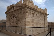
Roman temple
The structure, located in a dense residential area, was exposed from 1983 five meters below today's ground level. The excavation is secured by a wall with a fence, and stairs lead down to the entrance of the temple. The rectangular building made of neatly joined limestone blocks is accentuated at the base zone and the eaves by a surrounding frieze that forms a triangular gable on the narrow sides. A vertical structure is made by indicated pilasters with Corinthian capitals at the corners and two in the middle of each side. Both narrow sides were originally opened by high arched doors. This construction contradicts the usual layout of a temple, which is otherwise oriented towards an altar. At the southern corner of the entrance on the east side, a carefully restored stone staircase with several platforms leads to the roof.
Several inscriptions were found that refer to the building as naos , meaning “sanctuary”. Water pipes from Roman times on the outer walls suggest that a well sanctuary was built here over a water point. A monumentally rebuilt, revered waterhole is suspected.
A dedicatory inscription on the architrave above the inner door of the eastern entrance room was important for the possible dating. The inscription states that a strator of a commander in the Roman army (who is not adequately appreciated by the usual translation of "horse servant") paid for the architrave. It was first published in 1899 by Rudolf Ernst Brünnow. Construction may have started as early as the 1st century AD, the official inauguration was in 245 and falls during the reign of Emperor Philip Arabs , who was born not far in what is now the small town of Shabwa in the Hauran region.
During the Islamic period, the gates were walled up to use the building as a fortress. The coarser stone blocks and the crenellated wreath with which the roof was raised also date from the Islamic period. The lining of the entrance gates was not removed for structural reasons.

Roman temple, south side
View from the northwest

Interior, partition after today's small entrance door in the east


Other buildings from Roman times
Located three kilometers east of the city, on the right-hand side of the road towards Palmyra, the sandstone remains of a poorly preserved Roman fort from the 2nd century AD. Parts of the south gate and the weapons store are still about two meters upright. There are also the remains of a Roman basalt dam .
literature
- Elfriede Brümmer: The Roman Temple of Dmeir. Preliminary report. Damaszener Mitteilungen 2, 1985, pp. 55-64
- Manfred Klinkott: Results of the construction survey on the "Temple" of Dmeir. Damaszener Mitteilungen 4, 1989, pp. 109-161
Web links
- Your Travel Guide to Syria. Al-Dumair. Souria.com Photos of the temple and the Roman military camp
Individual evidence
- ↑ Karl-Heinz Ohlig , Gerd-Rüdiger Puin (ed.): The dark beginnings. New Research On Origins And Early History. In: Schiler , Berlin 2007, page 39, footnote 58 quarters ( in the Google Book Search).
- ↑ Martin Stäheli: The Syrian foreign policy under President Hafez Assad. Balancing acts in global upheaval. Franz Steiner Verlag, Stuttgart 2001, pp 262. ( in the Google Book Search).
- ^ Eugen Wirth : Syria, a geographical country study. In: Wissenschaftliche Buchgesellschaft , Darmstadt 1971, p. 256.
- ↑ Joshka Wessels: What is the future for ancient water tunnels in the Middle East? In: Arid Lands Newsletter , No. 57 (English).
- ^ Frank Rainer Scheck , Johannes Odenthal: Syrien. High cultures between the Mediterranean and the Arabian desert. DuMont , Cologne 1998, pp. 170f.
- ↑ Norbert Ehrhardt : The ala Vocontiorum and the dating of the Temple of Dmeir. In: Zeitschrift für Papyrologie und Epigraphik , Vol. 65, 1986, pp. 225-230.