
Agnesviertel
The Agnesviertel in Cologne is the northernmost part of the Neustadt-Nord district and belongs to the city center district . It is named after the parish church of St. Agnes , built in neo-Gothic style , which was built at the turn of the 20th century in the center of the suburban area on Neusser Platz, which was previously developed by the city architect Stübben . The building is the second largest church in Cologne and was consecrated to St. Agnes at the request of its founder Peter Joseph Roeckerath in memory of his late wife Agnes .


topography

The area of the district, which was sparsely developed before it was built and mainly used as arable land, is bordered on its east side by the Rhine . It has no natural hills and is not crossed by any running waters.
Out of town, the Agnesviertel on the other side of the Innere Kanalstraße is joined by the upstream districts of Nippes and Riehl , which are connected to the city center by several radial streets running through the district. From these streets, Neusser Straße took over the role of the main street and developed into the most important shopping street. The boundary to the old town is formed by the northern Ringstrasse with its sections Theodor-Heuss-Ring and Hansaring and the Ebertplatz located between them , which is also the largest traffic junction in the district. The route of the railway line along Krefelder Straße separates the quarter from the rest of the northern Neustadt.
Within these boundaries, a quarter developed that has a closed structure consisting mainly of residential buildings on the older streets of its core area. In contrast to this, mainly on the side of the district facing the Rhine, the development is loosened up. A mixed construction was created here, in which, interspersed with a lot of "green", villa plots, high-rise buildings of various corporations and administration buildings are lined up.
History of origin

Roman traces
The route of the former northern Heerstraße ran over Neusser Straße and continued (at the height of today's Agneskirche) on Niehler Straße as Limesstraße between the Lower Germanic metropolis Colonia Claudia Ara Agrippinensium to Novaesium , the Neuss legionary camp.
As in the south and west in front of the ancient city, there was an elongated burial ground on this arterial road leading from the north gate over Marzellenstrasse and Eigelstein , which was mainly occupied in the second half of the first century.
Although the burial center of the northern necropolis was near the north gate of the Roman city wall on the site around the later Church of St. Ursula , traces of the Romans were also found in the area of the Agnesviertel. Already at the end of the 19th century on the corner of Neusser and Schillingstrasse found skeletal graves with additions from the 3rd century, whose dead were buried lying in a south-north direction, were described. During the construction of the Church of Agnes, several ash boxes were uncovered, one of which was made in two parts, which were set up in the surrounding facilities after the church was completed. Pottery and glassware were found during these excavations; on the other hand, the weathered inscription of a tomb was found at another site at the beginning of Neusser Strasse. Another addition of a cult type was a heavily damaged statue of a Ganymede watering the eagle of Zeus , which was found in the direction of Nippes. An excavation on Neusser Wall (at the level of the church) revealed two bronze candlesticks , a specimen of a hunting dog, a raw statue of Hercules , a bronze pen and a translucent glass bottle in the shape of a pig, its contours and eyes brown glass threads had been emphasized. Also on today's Niehler Straße, the continuation of the former Heerstraße (behind the Agneskirche), you found it. Two life-size male portrait heads, which had adorned graves as busts, and fragments of a tomb were recovered .
As the illustration on the right shows, jewelry work in various forms was found among many objects found in everyday life. The wealth of information received through deciphered inscriptions, the interpretation of everyday objects, the dating of the materials and processing methods gave the researchers a picture of the living conditions at that time. Some of these objects were presented in the permanent exhibition of the Roman-Germanic Museum in Cologne.
From the Middle Ages to the Modern Age

The field corridors of the early city were the barely populated areas in front of the curtain wall, which were also known as Schweid . Most of the information on places, names or occurrences in the areas of these peripheral zones is documented by entries in the shrine books of the five farmers' banks , which were founded in the 13th century and whose members consisted of landowners and tenants, which were kept especially for these in the respective districts . The corridor entries cited before the establishment of such an organization for the Eigelstein district (founded in 1391 by the council, abolished in 1798 by the French administration) were taken from church documents according to Keussen , and in the case of the Eigelstein district from the St. Kunibert archives.
First mentioned as "Artland"
The area that is in front of the Eigelsteintorburg and the suburb of Niederich at that time was described as fertile farmland (Artland, also called waterland by the townspeople and in the springs) in the High Middle Ages , which was apparently largely owned by the St. Kunibert Monastery . In a document in 1227 it said: "3 iugera extra portam prope Egilsteins pay tithing to S. Cunibert, one morning is turned into vineyards."
Further documents provide details on the circumstances in this early period of the later Agnesviertel. In 1336 the area was called “terra in campis apud Eygilsteyn” and in 1376 a garden was explicitly described in connection with the Torburg as a location as “terra arabilis extra portam Eygelsteine iuxta ortum Cristine”. In 1404, the area in front of the Torburg was described as "Artland by ver Stynen garden, ind schiessent up den oeversten wech zu Mauwenhem worth" (today's district of Cologne-Mauenheim ). In 1415 the area was designated as Wasserland, the entry in the shrine read: "dat Wasserlant vur der Egelsteyns portzen by Stynen garden". In 1444 the current district of Cologne-Niehl was mentioned, it was called (probably concerning the northern part of the area) "Artlant buyssen dem Egelsteyne ... zo Nyele worth".
Almost a hundred years after the "Christine Garden" was first mentioned in 1474, it was recorded as the property of Mr. Buytzen and was now called "by ver Stynen garden, et vocantur hern Buytzen lands". In 1482, an entry referred to the name of the area that was customary for the townspeople, who called the Artland “dat Wasserlant”. In 1494 an area was named as “bij frauwen Stijnen garden zor stede Wert”, and with a note from 1497 the shrine entries for the field in front of the Eigelstein end. This leads three acres of Artland, called "der Berch buyssen der Eigelsteinsportzen".
Markscheide Bischofsweg
In this foothills of the northern part of the city formed relocating bishop path in the 15th century the onshore market - or dividing line between the rich urban and Electoral Cologne , so episcopal area. At that time the path was known as “des bischoffs straisse” or “des buschoffs wech”. It lay on the land side of the curtain wall and delimited the urban fields from the northern district of Eigelstein to the district of Severin in the south.
Old street and path names
At the fork in the road to Nippes and the old Merheim on the left bank of the Rhine, today's Cologne-Weidenpesch , as well as today's Niehler Strasse, which led straight across the hamlet of "Schorrenstein" and further along the "Weidenpeschhof" to "Niel" on the Rhine ( see tranchot map), since 1675 the Kevelaerkreuz stood exactly where the tower of St. Agnes stands today.
Modern times and customs limits

To the west and north of the Bischofsweg, the land in front of the Eigelstein was essentially surrounded by the glory of Mauenheim, located in the "Elector of Cologne" , whose properties, which were mostly owned by St. Kunibert Abbey, were affected by secularization in the French era . Up to this time there were often smaller and larger disputes between the city and the area of Kurköln.
The customs at “Merheim”, which was posted in the former suburb on the left bank of the Rhine and was an hour's walk from the Cologne city walls, had been leased by the city of Cologne and then moved to the Eigelsteintor. This meant that all farms between northern Merheim (later Weidenpesch) and Cologne, with their products, but also the productions of the brickworks of the local clay pubs (1477 land “up der alder Leymkule up der Neilrestraissen”), which were transported into the city, were exempted from the demands of the Electorate of Cologne . Nevertheless, there were frequent attacks by customs officers who violated applicable law and thereby triggered lawsuits and legal disputes.
Exemplary was a lawsuit that began in 1740 for years over a confiscated horse and a cart laden with bricks because a required duty of four Albus per cartload had not been paid. The stones were intended for St. Achatius zu St. Andreas . They were burned in a brick oven on Bischofsweg in front of the Eigelsteinpforte, that is, on the territory of the city of Cologne .
In the judicial dispute around 1740, the defendant of the Electorate of Cologne customs officer did not recognize the suspension of the Electorate of Cologne customs sovereignty in the disputed area. They referred to the yardstick at Godorf at the Judenbüchel in front of the Severinstor and demanded the same rights for the customs at “Merheim” and for the one at the Bischofsweg in front of the Eigelsteinpforte as they were applied in all the territories of the Electorate of Cologne. The city of Cologne, as the plaintiff, demanded free import of goods from the area of the Burgbann and referred to the promises received from Emperors Charles V to Charles VI. , as well as on documents of Emperor Friedrich III. from 1475, Friedrichs II. from 1242, Archbishop Friedrichs from 1393 and that of Archbishop Heinrichs from 1229.

The customs controls for the goods arriving from the northern foreland probably took place at the outer works of the Eigelstein Gate, the first field-side outer gate with inner courtyard of which was mentioned in 1402. Later views from 1571/72 and 1642 showed an eight-sided forecourt with an outer moat, which was equipped with three towers and a cavalier's building and was based on building measures from 1474/76. The outdoor facilities, however, had been constantly expanded and improved until 1613, but they were then replaced by an acute-angled earthwork . This defense system had two terraces and, surrounded by the outer moat, protruded into free, undeveloped foreland, as can still be seen on an ink drawing "Laporteries" at the end of the 18th century. With the arrival of the French in the Rhineland and Cologne, the previous tariffs also disappeared. A guard house built there in 1614 was demolished in 1826 after the French era by the Prussian administration under the city architect Peter Schmitz .
Changes in French time

The Bischofsweg formed the canton border in French times and remained the border between the city of Cologne and the adjoining municipalities or districts until the first incorporation of the modern era in 1883 (area of the Cologne Neustadt) . It followed here in its course roughly in line with today's Maybachstrasse, Schillingstrasse and Sedanstrasse; at the end of Sedanstrasse it bent north and ran parallel to the Rhine as far as Riehl.
Prussian Cologne
After the French era, when the Prussian administration began to build, city architects were responsible for the urban planning and execution. In contrast to the engineers who were previously often entrusted with these tasks, they were trained architects who, apart from restoring medieval buildings, now influenced the cityscape with their designs.
Military installations

After 1815 four structures of the fortress ring Cologne were erected in the area of what would later become the Agnesviertel , consisting of three forts and a lunette .
Fort IX (Prince Friederich of the Netherlands) , located on Krefelder Strasse up to the city expansion Ossendorfer Strasse at the height of today's Inner Canalstrasse , was one of these facilities . Due to its inclusion in the fortification belt, its location caused a kink in the course of the outer ramparts that were to be built later, on the Krefeld ramparts planned by city architect Stübben and decided in 1889 (alignment plans 38 and 40) for the Cologne Neustadt. Fort IX was demolished in 1912/13.
Fort X , named after Prince Wilhelm of Prussia and preserved as a monument, was built between 1819 and 1825. It remained in Prussian military possession in 1881 and also became part of the new outer wall at that time. It was on the Neusser Wall, which was planned as an avenue and finally named in July 1899, and then, like the other military installations of this chain of fortifications, passed into municipal ownership in 1907. As such, the fort was integrated as one of the best preserved structures of the Prussian military in a park that was generously designed under gardening director Fritz Encke .
Even the Fort XI , also known as Riehler ski jumping facility, stayed in 1881 for the time being held by the military. As the northern counterpart of Fort I, the Rheinschanze, the fort formed the end of the ramparts at that time.
A partial demolition of the fort is said to have been carried out in 1912, a photograph from 1911 shows a horseshoe-shaped structure. It was located a little lower down and at that time was shown in front of an amusement park that was visible in the background, from which it was separated by a belt of trees. Parts of the brickwork core can be seen . The inner courtyard shows two- and three-storey buildings in a semicircle on the outside, the inner courtyard sides with high arched windows. A high round tower towered over the fortified plateau of the complex, which was secured by surrounding balustrades . The inner wall was joined by the throat ditch with its outer wall.
The former lunette VII , located at today's intersection of Weißenburg - (only named as such in 1892 with reference to Prussian military history) and Hülchrather Strasse (named as such in 1895), was blown up around 1911 at the latest, except for a few commercially used facilities in the southern part of the city .
Just a few years after the completion of the new outer fortifications, long-term negotiations took place between the city of Cologne and the Prussian military treasury, which in 1907 led to the acquisition of the site and its inner fortification ring for around 25.5 million marks (including the facilities on the right bank of the Rhine) led.
After the dissolution of the inner mounting ring to the outer facilities were replaced along the military ring that was municipal councilor Carl Rehorst been involved in the plans for the transformation of obsolete military area. His specifications were then carried out under gardening director Fritz Encke , who also connected the northern part of the city with the beginnings of an inner green belt .

Fortification development of the city of Cologne

Entrance to Fort Wilhelm of Prussia
Rose Garden Fort X


port
In 1824, a security harbor was built where the park stretches between the streets of the belt today.
builder
These architects of the post-French era were, according to Peter Schmitz , who had already been called “Architecte de ville” during the cantonal administration , but could not change the desolate state of the city due to a lack of funds , from 1822 officially Johann Peter Weyer , who was in the for over 20 years Service of the city was active and was replaced in 1844 by Bernhard Wilhelm Harperath . His successor was Julius Carl Raschdorff after Harperath's death in 1864 . He had been responsible for the building construction as the second master builder since 1854, after the building authority had been split up as a result of the beginning building boom , and worked with Harperath. Raschdorff remained active for the city until 1872 and handed over his office to Hermann Weyer , who led it as a city architect until 1889 and was then replaced by Friedrich Carl Heimann . Heimann also created prestigious buildings in the suburban districts that were not yet incorporated into the suburbs, which were becoming more dense in their development, but his successor, the building councilor Josef Stübben , who was then appointed as city architect , was the one who significantly planned the urban belt of the New Town of Cologne between 1881 and 1898 and thus also influenced the development and design of the Agnesviertel.
Founding period


In 1839 the Rheinische Eisenbahn-Gesellschaft began building the line from Cologne via Düren to Aachen; the extension to Belgium created the world's first cross-border railway line in 1843. For this purpose, the Am Thürmchen train station was built on today's street An der Münze . In 1855, the Cöln-Crefeld Railway Company opened the first section to Neuss; in Cologne the line ended next to the Rheinische Eisenbahn station.
From the middle of the 19th century an era began that is known as the Wilhelminian era and in which the city experienced a steady economic boom. The investments made by industrialists created jobs in factories and small businesses. The resulting railway connections promoted sales and travel. The city, which had become attractive and narrowed in its curtain wall, continued to grow.
The general upward trend culminated in the war of 1870/71, which went well for Germany , brought immense reparations from France to the Prussian state and also improved the financial situation of the municipalities. In 1881 the council decided to buy the area of the city wall for 12 million marks and with this decision initiated the overdue city expansion. It gave the local companies a perspective and gave them the opportunity to expand .
During this time, plans also began to create an appropriate infrastructure for the areas of the envisaged incorporations.
Architects and Housing
In the post-French period, according to the city's former architect and curator , Hans Vogts , Johann Peter Weyer and Mathias Biercher, the architects and builders who significantly influenced Cologne's building industry at the time. Until his departure in 1844, Weyer is said to have shown himself to be a driving force as well as a planner and organizer of urban development , whereas Biercher, as a city councilor, was the politically active one who continued to use his influence during the 1830s and further into the 40s and 50s. The residential buildings that were built during this time and completed the development of the new streets were usually simple structures that could only satisfy equally simple living demands. They corresponded to a general in the Rhine region usual style of a three-storey three - or four-window house with occasionally grown wings, but retained the manageable for residents character of the original family home.
According to Vogts, however, residential buildings from the first half of the 19th century are no longer preserved, apart from the remains of a wall on the Roman tower and a narrow house facade in Lintgasse in the old town .
Population growth, the creation of jobs and the industrialization that began in the Cologne area also meant that the construction industry was able to record enormous growth. The increased demand for living space led to the establishment of housing cooperatives , which were able to build apartment buildings on a large scale. Some of the architects working in this sector are known from the city's historical sources.
One example is the architect Johann Jacob Claasen. Claasen, who has lived in Cologne since 1846, was a pupil of Ernst Friedrich Zwirner and, in addition to working out municipal commissions (restoration of Gürzenich and Haus Mühlen), from 1846 primarily dealt with planning the private sector in residential construction in the emerging city. Likewise, Heinrich Krings , who lives in his villa at Riehler Strasse 13 , worked as an architect in his hometown of Cologne after completing his studies and turned to residential construction in connection with the planned “Neustadt”.

Neusser Straße 27, built around 1905

Melchiorstraße 3, built around 1890

Am Zuckerberg 9, built around 1906
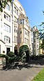
Blumenthalstrasse 21, built around 1911


At the end of the 19th century in the course of the city expansion, which began with the removal of the historic city wall, upper-class residential buildings were also built on the outskirts of the new town. Among other things, it was the architectural office “ de Voss & A. Müller ”, whose designs resulted in numerous noble villas there. Theodor Roß , who had been working as a private architect in Cologne since the 1890s, had specialized in sacred buildings , but from 1913 switched to the residential construction division and worked for the Cologne Hereditary Building Association, among others.
The kaleidoscope of the styles of this era, created by a large number of architects involved in urban development, was reflected in the house facades of the new buildings. However, as Hans Vogts resignedly noted in his work on the “Cologne residential building”, the alienation from the domestic architectural style took place throughout Germany. The apartment house style with self-contained rental apartments, which was later practiced by the Cologne architects based on the Berlin and Parisian model, replaced the last remnants of traditional architecture, according to Vogts.
Development of the new town
The Neustadt was built according to the plans of Josef Stübben . After the demolition of the medieval city wall and the ramparts in front of it from 1880, a splendid boulevard was built a few meters in front of the wall, enclosing the entire old town in a semicircle.
The inner belt of fortresses bounded the urban expansion towards the outside . The railway was relocated to the inside of this fortress belt. Even before the First World War , the new inner city wall was abandoned and the Cologne Fortress was finally razed as a result of the Versailles Peace Treaty . This enabled large parts of the former belt of fortifications to be redesigned into a continuous green area, the inner green belt .
The Neustadt was planned mainly as a residential area for the middle-class and upscale population. The trend of wealthier citizens to build detached villas on the outskirts with surrounding gardens did not emerge until about two decades later. Overall, the construction period of the new town lasted until the 1920s, with the largest part being completed by around 1910.
According to the character of the whole building project, church buildings were built by the denominations. Often these were created in prominent urban areas. They are often markings for the visual axes within the straight / star-shaped road network.
Development progress
The first street in the Agnesviertel was Sudermanstraße. The district also has a fire station and a Dreikönigsviertel around the fire station. In 1902 there was a church in Kappesfeld, and the pastor rented a place on Lupusstrasse because there was no parsonage.
Worth seeing
- Churches
- St. Agnes , construction costs approx. 650,000 marks
.jpg)
- St. Gertrud , designed by Gottfried Böhm in 1960 and built between 1962 and 1965.
- Thomas Church
- Monuments
- Among the laid in Agnesviertel stumbling blocks see the stumbling blocks in the district of Cologne Neustadt-Nord List
- List of architectural monuments in the Neustadt-Nord district of Cologne
Infrastructure
- Authorities

- Higher Regional Court on Reichenspergerplatz, New Baroque Palace of Justice, built between 1907 and 1911.
- Regional Labor Court and Labor Court Cologne
- Oberfinanzdirektion Nordrhein-Westfalen
- Cologne North Tax Office
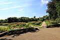
- Fort X
- Domin-Park rose garden as an oasis of calm
- Lentpark
- Lentpark , formerly the ice and swimming stadium in Cologne
- Breweries
- Hansa Brewery, Krefelder Strasse 36
- traffic
- Ebertplatz underground station opened in August 1974
- Reichenspergerplatz underground station
|
(* Trankgassenwerft) |
|
|
population
Prominent citizens
- Otto Müller (1870–1944), Catholic priest and resistance fighter in the Cologne district
- Bernhard Letterhaus (1894–1944), resistance fighter in the Cologne district (came from the Agnesviertel)
- Nikolaus Groß (1898–1945), trade unionist and resistance fighter in the Cologne district (came from the Agnesviertel)
- Vilma Sturm (1912–1995), lived in Merlostrasse from 1954
- Heinrich Böll (1917–1985) lived with his family on Hülchrather Strasse in the 1970s
- Carola Stern (1925–2006) founded the German section of Amnesty International with Gerd Ruge in Cologne, with its main office in Domstrasse
- Gerhart Baum (* 1932), who has been in Cologne since 1952, lived in the Inner Canal Street as Federal Chairman of the Young Democrats and Councilor of Cologne until the first half of the 1970s
- Richard Rogler (* 1949), in Cologne since 1977, lives in the Agnesviertel
- Frank Schätzing (* 1957)
- Günther Kaußen († 1985), real estate entrepreneur, owned over 35,000 apartments in old buildings in Germany and lived on Neusser Straße
Election results
- Voters, constituencies: 10,413 to 10,422 in the 2010 state elections
Greens: 34.8%, SPD: 29.9%, CDU: 16.0%, Left: 5.9%, FDP: 5.4%, others: 7.9%
Web links
- Official website of the city of Cologne for the Neustadt Nord district
- Agnesviertel on Facebook
- Private photos from the neighborhood
- Kölnische Rundschau to the rose garden: "haven of peace between rose beds"
- Old fire station
literature
- Hermann Keussen : Topography of the city of Cologne in the Middle Ages. 2 volumes. Cologne 1910. (Reprint: Droste, Düsseldorf 1986, ISBN 3-7700-7560-9 and ISBN 3-7700-7561-7 )
- Paul Clemen et al. (Hrsg.): The art monuments of the city of Cologne. Volume VI, Section I. Sources, and Section II., Joseph Klinkenberg : Das Römische Köln . Druck und Verlag L. Schwann, Düsseldorf 1906. (Reprint: Pedagogical Verlag Schwann, 1980, ISBN 3-590-32108-3 )
- Joachim Bauer, Carmen Kohls: Cologne under French and Prussian rule. In: Werner Adams, Joachim Bauer (ed.): From the Botanical Garden to the Big City Green - 200 Years of Cologne Green (= city traces - monuments in Cologne. Volume 30). Bachem Verlag, Cologne 2001, ISBN 3-7616-1460-8 .
- Beate Eickhoff: St. Agnes in Cologne, a quarter and his church Marzellen Verlag, Cologne 2001, ISBN 3-9806384-4-8 .
- Adam Wrede : New Cologne vocabulary . 3 volumes. 9th edition. Greven Verlag, Cologne 1984, ISBN 3-7743-0155-7 .
- Angela Weyel: Cologne's Neustadtviertel around St. Agnes from the end of the 19th century to 1933 in terms of social history. Term paper for the 1st state examination. Cologne 1998.
- Paul Clemen et al. (Eds.); Hans Vogts , Fritz Witte: The art monuments of the city of Cologne. Volume 7, Section IV: The profane monuments of the city of Cologne. Düsseldorf 1930. Verlag L. Schwann, Düsseldorf. (Reprint: Pädagogischer Verlag Schwann, 1980, ISBN 3-590-32102-4 )
- Ulrich S. Soénius (Hrsg.), Jürgen Wilhelm (Hrsg.): Kölner Personen-Lexikon. Greven, Cologne 2007, ISBN 978-3-7743-0400-0 .
- Carl Dietmar: The Chronicle of Cologne . Chronik-Verlag, Dortmund 1991, ISBN 3-611-00193-7 .
- Hans Vogts: The Cologne house until the middle of the 19th century . 2 volumes. Verlag Gesellschaft für Buchdruckerei, Neuss 1966.
- Sybille Fraquelli: In the shadow of the cathedral, neo-Gothic architecture in Cologne 1815 to 1914 . Böhlau Verlag, Cologne / Weimar / Vienna 2008, ISBN 978-3-412-20162-3 .
- Hiltrud Kier : The Cologne Neustadt: planning, development, use. (= Contributions to the architectural and art monuments in the Rhineland. Volume 23). 1st edition. Schwann, Düsseldorf 1978, ISBN 3-590-29023-4 .
Individual evidence
- ↑ The outer streets. In: Paul Clemen: The Roman Cologne. P. 247 ff.
- ↑ a b The grave fields on the north side. In: Paul Clemen: The Roman Cologne. P. 269 ff.
- ^ Adam Wrede, Volume I, p. 94.
- ↑ a b c The Cologne field corridors, Eigelstein district. In: Hermann Keussen: Topography of the city of Cologne in the Middle Ages. Volume II, p. 315 and 324 f.
- ^ Adam Wrede: New Cologne vocabulary. Volume I, p. 80.
- ^ Hugo Poth: The parish church of St. Agnes in Cologne. Commemorative publication for the 50th anniversary in 1952. Archive of the parish, p. 11.
- ^ Archives NRW, file number: C 582/1397
- ^ Vogts, Witte: The art monuments of the city of Cologne. Volume 7, Section IV: The profane monuments of the city of Cologne. City fortifications p. 116.
- ^ The French Years. Catalog for the exhibition at the HAStK from October 6, 1997 to December 16, 1994. HAStK Cologne, p. 33.
- ^ Hugo Poth: The parish church of St. Agnes in Cologne. Commemorative publication for the 50th anniversary in 1952. Archive of the parish, p. 152.
- ↑ a b c d e Cologne as a fortress city. In: Hiltrud Kier: The Cologne Neustadt - planning, development, use. S, p. 7 ff. And information on the development of the new streets and squares, p. 123 ff.
- ^ Description based on a photograph of Fort XI from 1911. Photo RBA Cologne, archive no. 136403 In: Hiltrud Kier: Die Kölner Neustadt - planning, emergence, use . Photo credits section, p. 217.
- ↑ Werner Adams, Joachim Bauer (Ed.): From the Botanical Garden to the City Green - 200 Years of Cologne Green. Systems on the fortifications of the former fortress belt, p. 127 f.
- ^ Henriette Meynen: Eigelstein-Glacis. In: Joachim Bauer, Carmen Kohls: Cologne under French and Prussian rule. In: Werner Adams, Joachim Bauer (ed.): From the Botanical Garden to the Big City Green - 200 Years of Cologne Green (= city traces - monuments in Cologne. Volume 30). P. 29.
- ↑ Cologne architecture with further evidence ( Memento from December 13, 2013 in the Internet Archive )
- ^ Ulrich S. Soénius, Jürgen Wilhelm: Kölner Personen-Lexikon.
- ^ A b Eickhoff: Railway systems in Cologne. 1855, p. 8.
- ^ Carl Dietmar: The Chronicle of Cologne. P. 270.
- ↑ Sybille Fraquelli: Architecture of the Gothic Revival in Cologne from 1815 to 1914. Chapter “The Suburbs”, p. 223.
- ^ A b Hans Vogts: The Cologne house until the middle of the 19th century. Volume II, p. 609 ff.
- ^ Ulrich S. Soénius, Jürgen Wilhelm: Kölner Personen-Lexikon. Pp. 102-103.
- ↑ Sybille Fraquelli: Architecture of the Gothic Revival in Cologne from 1815 to 1914. Directory of architects and short biographies. (CD-ROM).
-
^ Heinrich Böll in the Agnesviertel. In: WDR 3 , October 30, 2017 ( ARD Mediathek , available until December 30, 2099):
- In the 1970s Heinrich Böll lived in the Agnesviertel in an old building on Hülchrather Strasse near Neusser Strasse. This is where his novel The Lost Honor of Katharina Blum was written . He bought the apartment in which he lived with the translator Annemarie Böll and their three children in 1972 with the prize money of the Nobel Prize for Literature .
- ^ Jürgen Salz: Network for Human Rights. In: networks . Title 2/2015 of the parish letter for St. Agnes, St. Kunibert, St. Ursula, St. Gertrud, pp. 12–13 (here: p. 13).
- ↑ Curriculum vitae on the homepage of his law firm.
- ↑ Peter Berger: Cologne's most beautiful page. In: Kölner Stadt-Anzeiger , October 25, 2011, accessed on July 27, 2020.
- ↑ Cabaret artist wants to continue despite the threat. In: Nordwest-Zeitung , January 11, 2015, accessed on July 27, 2020.
- ↑ Structural data of the state election 2010, p. 240 (PDF file)