Ahmedabad (District)
| Ahmedabad District | |
|---|---|

|
|
| State | Gujarat |
| Administrative headquarters : | Ahmedabad |
| Area : | 8107 km² |
| Residents : | 7,214,225 (2011) |
| Population density : | 890 inhabitants / km² |
| Website : | ahmedabad.gujarat.gov.in |
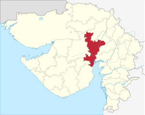
The Ahmedabad District ( Gujarati : અમદાવાદ જિલ્લો ) is one of 26 districts of the Gujarat state in India . The city of the same name Ahmedabad is the capital of the district. The last census in 2011 showed a total population of 7,214, 225 people.
history
From pre-Christian times until 1298, the area - like the entire region - was ruled by various Buddhist and Hindu rulers. The first civilization was the Indus culture . The first state known by name was the Maurya Empire , the last non-Muslim dynasty were the Solanki . After centuries of military conflict with Muslim conquerors and rulers in northern India, it was occupied by Muslim soldiers in 1298. Thereafter, various Muslim dynasties ( Sultanate of Delhi , Sultanate of Gujarat and the Mughals ) ruled until 1753 . In 1753 the area became part of the Hindu Marathon Empire . Between 1802 and 1818 all regions of what is now the district came under British rule. The district became part of the Northern Division of the British administrative region of Bombay Presidency . With India's independence in 1947 and the reorganization of the country, it became part of the new state of Bombay in 1950 . In 1960 this Indian state was divided and the area came to the newly created state of Gujarat. Some areas of the district were separated from the previous district in 1964 and formed the new Gandhinagar district .
population
Population development
As everywhere in India, the population in the Ahmedabad district has been growing rapidly for decades. The increase in the years 2001–2011 was around 24 percent (24.03%). In these ten years the population increased by almost 1.4 million people. The following table shows the exact numbers:

Significant places
The most populous town in the district is the metropolis Ahmedabad with over 5.5 million inhabitants. Other major cities with a population of more than 20,000 people are Dholka, Viramgam, Sanand, Bopal, Bavla, Dhandhuka and Kathwada. The urban population makes up 84.04 percent of the total population.

Population of the district by confession
A clear vast majority of the population are Hindus. The Muslims and Jainas are significant minorities. The following table shows the exact religious composition of the population:
| year | Buddhists | Christians | Hindus | Jainas | Muslims | Sikhs | Other | not specified | Total | |||||||||
|---|---|---|---|---|---|---|---|---|---|---|---|---|---|---|---|---|---|---|
| number | % | number | % | number | % | number | % | number | % | number | % | number | % | number | % | Residents | % | |
| 2001 | 2,424 | 0.04% | 41,947 | 0.72% | 4,921,747 | 84.62% | 170.093 | 2.92% | 662.799 | 11.40% | 11,751 | 0.20% | 3,155 | 0.05% | 2,603 | 0.04% | 5,816,519 | 100.00% |
| Source: 2001 India Census | ||||||||||||||||||
District population by language
A clear vast majority of the population of 77 percent speaks Gujarati. Significant linguistic minorities with more than 100,000 native speakers are Hindi (with Hindi dialects even 722,000 people), Urdu, Sindhi and Marathi. Marwari (a Rajastani dialect), Malayalam, Rajasthani (16,737), Tamil (15,211) and Telugu (11,205) are used as mother tongues by over 10,000 people each. The following table shows the exact linguistic composition of the population:
| year | Gujarati | Hindi | Urdu | Sindhi | Marathi | Marwari | Malayalam | Other | Total | |||||||||
|---|---|---|---|---|---|---|---|---|---|---|---|---|---|---|---|---|---|---|
| number | % | number | % | number | % | number | % | number | % | number | % | number | % | number | % | Residents | % | |
| 2001 | 4,481,257 | 77.04% | 611,590 | 10.51% | 298.760 | 5.14% | 118.126 | 2.03% | 101,978 | 1.75% | 89,130 | 1.53% | 17.174 | 0.30% | 98.504 | 1.69% | 5,816,519 | 100.00% |
| Source: 2001 India Census | ||||||||||||||||||
Literacy
The enrollment rate in the district has increased from decade to decade thanks to efforts by the administration. This is why the number of residents who are able to read has increased significantly in the past few decades (from 1991 to 2011). Yet there are huge differences. While illiteracy is an exception among men in urban areas, more than 40% of rural women cannot read or write.
| year | Total population | urban | rural | |||||||
|---|---|---|---|---|---|---|---|---|---|---|
| Total | Men | Women | Total | Men | Women | Total | Men | Women | ||
| 1991 | 73.64% | 82.94% | 63.28% | 79.01% | 86.33% | 70.80% | 54.64% | 70.77% | 37.13% | |
| 2001 | 79.50% | 87.31% | 70.83% | 83.57% | 89.66% | 76.76% | 62.30% | 77.21% | 46.20% | |
| 2011 | 85.31% | 90.74% | 79.35% | 87.93% | 92.16% | 83.27% | 71.05% | 82.89% | 58.44% | |
| Source: India Censuses | ||||||||||
District Administration
Local administration
The district is divided into 11 talukas :
| Taluka | Population (2001) |
Population (2011) |
Population (%) (2011) |
Area (km²) | Surface (%) | Population density (2011) |
main place |
|---|---|---|---|---|---|---|---|
| Ahmadabad City | 4,220,048 | 5,585,528 | 77.42 | 304.14 | 3.75 | 18,365 | Ahmadabad |
| Barwala | 67,301 | 75.986 | 1.05 | 486.40 | 6.00 | 156 | Barwala |
| Bavla | 135.097 | 158.191 | 2.19 | 775.98 | 9.57 | 204 | Bavla |
| Daskroi | 459.183 | 321.817 | 4.46 | 656.02 | 8.09 | 491 | Ahmadabad |
| Detroy Rampura | 77,778 | 83.199 | 1.15 | 353.65 | 4.36 | 235 | Detroj |
| Dhandhuka | 134,662 | 145.252 | 2.01 | 1,765.87 | 21.78 | 82 | Dhandhuka |
| Dholka | 214,836 | 249,852 | 3.46 | 1,019.51 | 12.58 | 245 | Dholka |
| Mandal | 65,751 | 70,346 | 0.98 | 475.26 | 5.86 | 148 | Mandal |
| Ranpur | 76.128 | 92,926 | 1.29 | 430.67 | 5.31 | 216 | Ranpur |
| Sanand | 193,335 | 237.845 | 3.30 | 784.52 | 9.67 | 303 | Sanand |
| Viramgam | 172,400 | 193.283 | 2.68 | 885.25 | 10.92 | 218 | Viramgam |
Web links
- Map of Ahmedabad District
- Ahmedabad District
- Economy, nature and sights
- 2001 census result for Ahmedabad
- Ahmedabad District Statistical Handbook
Individual evidence
- ↑ 2011 census
- ^ History of the district up to 1900 in the Imperial Gazeteer Of India
- ^ Result of the 2011 census on city population
- ↑ Result of the 1991 and 2001 censuses ( Memento of the original from May 14, 2014 in the Internet Archive ) Info: The archive link was inserted automatically and has not yet been checked. Please check the original and archive link according to the instructions and then remove this notice.
- ↑ Results of the 2001 and 2011 censuses ( memento of the original from March 24, 2014 in the Internet Archive ) Info: The archive link was inserted automatically and has not yet been checked. Please check the original and archive link according to the instructions and then remove this notice.
Coordinates: 22 ° 59 ' N , 72 ° 36' E


