Albula Valley
| Albula Valley | ||
|---|---|---|
|
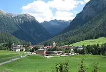
Albula valley to the east. Left the road to Lenzerheide , in the middle Surava |
||
| location | canton of Grisons | |
| Waters | Albula | |
| Mountains | Alps | |
| Geographical location | 775 285 / 168475 | |
|
|
||
| length | 20 km | |
The Albula Valley ( Rhaeto-Romanic ) is a 20 km long valley in central Grisons, through which the Albula flows . It belongs to the cultural and linguistic region of Surmeir .
geography
The Albula Valley stretches from the Albula Pass to the Schin Gorge . The village of Bergün / Bravuogn with the Latsch and Stugl fractions is located in the upper valley level above the Bergünerstein at 1,400 meters . Below the Bergünerstein, in the valley floor at 900 to 1050 meters, the villages Filisur , Alvaneu-Bad, Surava , Tiefencastel and Alvaschein lie from east to west . The villages of Schmitten , Alvaneu , Brienz / Brinzauls , Vazerol, Lantsch / Lenz and the districts of the municipality of Vaz / Obervaz : Lain , Muldain and Zorten are located on the sun terrace on the right side of the valley at 1,100 to 1,400 meters, and the villages on the left side of the valley Mon , Stierva , Solis (belongs to the municipality of Vaz / Obervaz) and Mutten . The Lenzerheide plateau extends north of Lantsch / Lenz . Up to the watershed between Valbella and Parpan, the Lenzerheide also belongs to the Albula valley. The highest point is the Piz Kesch at 3418 meters, the lowest point in the Schin Gorge at approx. 745 meters.
Population and language
On December 31, 2009, the Albula valley had 5743 inhabitants. The original language was Rhaeto-Romanic in the Surmiran and Bargunsegner dialects . Only the two Walser villages Schmitten and Mutten have always spoken German. The German language has gained increasing importance in the last few decades and is in the majority today. The municipality of Vaz / Obervaz (with Lenzerheide ) has by far the largest population . Lantsch / Lenz and Bergün follow.
Political division
On January 1, 2016, there was a regional reform and the formation of the administrative and planning unit Region Albula . Until the end of 2015, the Albula valley was politically organized in the three districts of Alvaschein , Belfort and Bergün and belonged to the Albula district .
tourism
The tourism is the main industry in the Albula valley. It mainly focuses on Lenzerheide and Bergün. In Bergün, the Albula Pass , which is closed to car traffic, is used as a toboggan run between Preda and Bergün in winter. At 7 kilometers, it is one of the longest in Europe. Almost the entire Albula valley (with the exception of the municipalities of Vaz / Obervaz and Mutten) is part of the Parc Ela nature park .
economy
In 2002 the Albula Valley received the Energy City Region label .
Attractions
The Albula Railway has been a UNESCO World Heritage Site since 2009 . The Landwasser Viaduct is particularly well known . It spans the Landwasser shortly before it flows into the Albula, and although it is called the Landwasser Viaduct, it is in the Albula Valley and not in the Landwasser Valley. The bridges at Solis are also impressive . Other sights are the Belfort ruins , the old churches of Mistail and Lantsch / Lenz . The architecture of the villages in the upper Albula valley (Filisur, Bergün, Stuls and Latsch) is already characterized by the Engadin architectural style .
Web links
Individual evidence
- ^ Region Albulatal Energiestadt , accessed on May 2, 2016.


