All-American Canal
| All-American Canal | ||
|
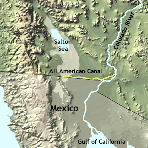
Map shows All-American Canal in yellow |
||
| Data | ||
| Water code | US : 238524 | |
| location | Imperial County , California , USA, on the border with Mexico | |
| River system | Colorado River | |
| origin | Junction from the Colorado River at Imperial Dam 32 ° 52 ′ 33 ″ N , 114 ° 28 ′ 21 ″ W |
|
| Splitting up | in irrigation channels of the Imperial Valley Coordinates: 32 ° 39 ′ 17 ″ N , 115 ° 38 ′ 27 ″ W 32 ° 39 ′ 17 ″ N , 115 ° 38 ′ 27 ″ W.
|
|
| length | 130 km | |
| Drain |
MQ |
428 m³ / s |
| Medium-sized cities | Calexico | |
|
View of the All-American Canal at Yuma |
||
The All-American Canal is a 130-kilometer-long canal in southeastern California . It brings water from the Colorado River to the Imperial Valley and nine cities. It is the only source of water in the Imperial Valley and replaced the Alamo Canal , which was mainly on the territory of Mexico . At Imperial Dam , about 30 miles northeast of Yuma , water from the Colorado River flows into the All-American Canal . Five smaller canals branch off the All American Canal and distribute water in the Imperial Valley . This canal system irrigates up to 250,000 hectares of agricultural land in what was originally one of the driest regions on earth. The All-American Canal is the largest irrigation canal in the world and can handle an average flow rate of 428 m³ / s. To be on the safe side, the structure was also designed for a larger amount of water and, if the entire canal volume is exhausted, it can enable a theoretical discharge of 740.6 cubic meters per second (26.155 cubic feet per second).
construction
The All-American Canal along with the Hoover Dam was approved by the Canyon Project Act in 1928 and built by the Bureau of Reclamation and Six Companies, Inc. in the 1930s . The All American Canal replaced the Alamo Canal (Spanish: Canal del Álamo ) or Imperial Canal from 1942 . The 23 km long Alamo Canal channeled water from the Colorado River into the Alamo River . The Alamo Canal was built from May 1900. The Alamo Canal was in use from May 1901 to 1942 . Only small parts of the canal ran in the USA.
Drowned refugees
The All-American Canal runs parallel to the Mexican border. Therefore it is crossed by illegal immigrants. It is dangerous to cross as the canal is deep and has cold, fast flowing water (8.8 km per hour). With over 500 people who have drowned in the canal since 1997, it is considered "the most dangerous body of water in the US".
Web links
- From the Colorado River to the Salton Sea: The story of Imperial Valley's Water (slideshow)
- All-American Canal - Maven's Notebook
- "Digging the World's Biggest Ditch," October 1936, Popular Science
- - 60 Minutes Episode: The All-American Canal (May 2, 2010 5:00 PM)
Individual evidence
- ↑ a b All-American Canal NASA page
- ^ Boulder Canyon Project Act . December 21, 1928. Archived from the original on June 13, 2011. Retrieved on May 24, 2020. (PDF)
- ^ The Deadly Passage of the All-American Canal . In: CBS News , May 3, 2010. Retrieved February 19, 2017.

