Altendorf (Essen)
|
Altendorf |
|

|
|
| Basic data | |
|---|---|
| surface | 2.49 km² |
| Residents | 22,691 (March 31, 2020) |
| Coordinates | 51 ° 27 '39 " N , 6 ° 58' 37" E |
| height | 62 m |
| Incorporation | Aug 1, 1901 |
| Spatial assignment | |
| Post Code | 45127, 45143 |
| District number | 07 |
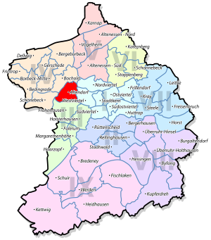
| district | District III Essen-West |
| image | |
|
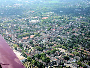
View from the northeast of Essen-Altendorf (2009) |
|
| Source: City of Essen statistics | |
Altendorf has been a district in the west of the city of Essen since 1901 . Before the incorporation, Altendorf was part of the Altendorf mayor's office .
The municipality of the same name, located in Essen's southeast on the Ruhr , Altendorf (Ruhr) received the name Burgaltendorf after it was incorporated into Essen .
character
As one of the most populous districts of Essen, Altendorf is characterized by dense residential developments and a few commercial areas. It is heavily burdened by the traffic on the main arteries that cut through the district, Altendorfer Strasse and Helenenstrasse / Oberdorfstrasse.
In the southern part of Altendorf is the listed Hirtsiefer housing estate, which was named after the central politician Heinrich Hirtsiefer . The northern part of the city is characterized by workers' settlements and allotment garden colonies . Due to the structural change in the Ruhr area, Altendorf was included in the state program for city districts with special renovation needs in 1998. Urban development measures were planned over a 15-year project period. In addition, residents have participated in cultural and social projects. As of December 31, 2018, 51.5 percent of the population had an exclusively German citizenship. Despite the implementation of several projects and construction measures, between 2011 and 2013, outside of facilities, 34.6 percent of private households living in Altendorf received subsistence benefits, which was the highest figure in the city. Of these, 29.4 percent received benefits under SGB II .
The City Center Altendorf shopping center was built in 2005 as part of the restructuring of the Krupp belt on the site at Altendorfer Strasse and the corner of Haedenkampstrasse, actually in the area of the Westviertel district .
On November 30, 2012, the redesigned Ehrenzeller Platz was reopened after a year of construction. It now offers a small café and is used to host the Altendorf weekly market on a regular basis.
In 2011, construction began on the approximately 1.8 hectare Niederfeldsee on Rüselstrasse. In August 2014, the 8.115 million euro project was completed. At the same time, the surrounding residential area was renovated by replacing 180 old apartments with 61 modern apartments in seven houses. On September 20, 2013, the 46 meter long foot and bike path bridge over the Niederfeldsee was opened in the presence of Mayor Reinhard Pass .
There are three primary schools in the district, with the two primary schools Hüttmannstrasse and Markscheide being merged into one Altendorf primary school since the 2008/2009 school year . The Markscheide primary school building was given up as a school building in 2011.
The comprehensive school Bockmühle is the secondary school in Altendorf, the cornerstone of which was laid in early November 1973 in the presence of Lord Mayor Horst Katzor . Construction costs of around 50 million DM had been estimated. Since the building complex from the 1970s is considered ailing, a new building with an investment of 90 million euros is planned. There is to be an architectural competition in summer 2020. Construction is scheduled to start in 2023.
Picture gallery
Niederfeldsee , south side
traffic
Road traffic
Two main roads, heavily used by through traffic, run through Altendorf. The Altendorfer Straße crosses the district in an east-west direction as part of the federal highway 231 . It is an important traffic artery between Essen city center, the Borbeck district and the neighboring town of Oberhausen to the west .
The street Helenenstrasse / Oberdorfstrasse runs in north-south direction in the eastern half of the district. It connects Bochold via Altendorf with Holsterhausen and Frohnhausen. The intersection of the two streets is referred to as the Helenenstrasse intersection after the interchange in the tram network .
Transportation
In local public transport , Altendorf is served by the Ruhrbahn on four tram lines , three daytime bus lines and three night bus lines. All trams and night bus routes in Altendorf serve the Helenenstraße stop , which is an important transfer point in Essen. At it is the most frequented level crossing of the light rail and tram networks in the Ruhr area . By changing the route of tram line 109 over Berthold-Beitz-Boulevard , this node was relieved. The following local public transport lines operate in Altendorf (as of June 2015) :
Between 1874 and 1960, the Essen-Altendorf station was on the Osterath – Dortmund Süd railway line . The tracks are currently being dismantled in this area.
population
On March 31, 2020, 22,691 people lived in Altendorf.
Structural data of the population in Altendorf (as of March 31, 2020):
- Proportion of population under 18-year-olds: 20.3% (Essen average: 16.2%)
- Population of at least 65-year-olds: 14.6% (Essen average: 21.5%)
- Proportion of foreigners: 37.1% (Essen average: 16.9%)
history
Early history
The name Altendorf comes from the name "Altes Dorf", which consisted of Oberdorf and Unterdorf. In the village there was the Frankish Oberhof honorary cell , the 800 on Hellweg founded and the first 966 in a deed Emperor Otto I mentioned. Since then, the farm has belonged to the Essen Abbey . The Oberhof Ehrenzell in today's area of Essen, Mülheim and Oberhausen were subordinate to 56 farms and taxable.
In 1220 Altendorf was mentioned as Altendorpe in the bailiff's role of Count Isenberg . The peasantry Altendorf was together with Frohnhausen and Holsterhausen referred to as three peasantry quarters.
In 1689 the Ehrenzell court was renamed Philipsenburg after the feudal man at the time.
industrialization

The first colliery, the United Hagenbeck colliery, was mentioned as early as 1575 . With the beginning of industrialization, Altendorf was shaped by collieries and the Krupp cast steel factory in the adjacent west quarter . The Altendorf area included the Schölerpad colliery , which began mining in 1678 , the Helene-Amalie colliery and the United Sälzer & Neuack colliery . Helene-Amalie colliery, named after Helene Amalie Krupp , is one of the earliest marl mines in the Ruhr area, while Sälzer & Neuack is the first civil engineering mine.
Due to the development of the Krupp factories in the 19th century, the population of Altendorf increased explosively. In the east of the municipality, the Krupp company built the Kronenberg workers 'colony from 1871 , one of the first Krupp workers' settlements. The settlement consisted of around 1500 residential units. Its location stretched from Altendorfer Strasse to Altendorf-Cronenberg station (today Essen West station ) on the Duisburg - Dortmund railway line opened in 1862 by the Bergisch-Märkische Eisenbahn-Gesellschaft . Another station, the Altendorf station , from 1907 Essen-Altendorf station , was located on the Mülheim (Ruhr) -Heissen - Essen Nord railway section of the Rhenish Railway Company opened in 1866 . After passenger traffic was discontinued in 1960 and the line was finally closed in 2002, it was redesigned in 2010 in the Altendorfer area to a pedestrian and cycle path. On August 23, 1893, an electrically powered tram drove for the first time on the route from Borbeck to Essen through Altendorf.
Affiliations
After secularization in 1803 and the creation of a new administrative structure, Altendorf belonged to Borbeck's mayor's office from 1808 . On January 1, 1874, the Altendorf community, which also included Frohnhausen and Holsterhausen, became Altendorf's own mayor . It was the largest rural community in Prussia . The first and only mayor of Altendorf was Wilhelm Kerckhoff . The administration first moved into a rented house on Margarethenstrasse in Frohnhausen. However, a piece of land has already been bought to build its own town hall, which was occupied on July 1, 1876. Today the Altendorfplatz street in Frohnhausen reminds of the location of the town hall.
Second World War
During the Second World War , Altendorf was largely destroyed by Allied bombing raids due to the immediate location of the Krupp cast steel factory , which was known as the German armory . Protection was provided by the round bunker on the corner of Körnerstrasse and the corner of Oberdorfstrasse, which was built from concrete by forced laborers from the Todt Organization in 1942 within nine months . It offered 675 people protection on eight floors behind 1.10 meter thick outer walls. Unlike almost all of the surrounding buildings, the bunker survived all air raids. During the Cold War , the bunker was put back into operation in 1987 and 1988 and served civil protection for around 1500 people until 2011 . There are five toilets on each floor, the ventilation with sand filter technology can be operated with a hand crank in the event of a power failure. In April 2014 the bunker was placed under monument protection. The largest bunker in the city of Essen was built between 1940 and 1943 on Helenenstrasse for 1150 people. It was also modernized during the Cold War and has been a listed building since July 2015. (See also: List of bunkers in Essen )
A snapshot of the Second World War is shown in September 1943, where on the former Krämerplatz, today on Haedenkampstrasse, was one of several Krupp workers' camps scattered across the city. During this time, the Krupp company employed more than 13,000 prisoners of war from Russia, Belarus and the Ukraine. They also lived in inhumane conditions here on Krämerplatz.
Churches
In 1892 the Catholic parish church of St. Mary of the Assumption , also called Altendorf Cathedral, was inaugurated. The Evangelical Christ Church followed on July 26, 1903 .
In 1907 the St. Anna Church was built. After reconstruction after the Second World War, the last service took place here in April 2008. St. Anna's demolition followed in the summer of 2015. The church gave way to an extension to the neighboring St. Anna's home for the elderly.
In 1957/58 the Catholic Church of St. Clemens Maria Hofbauer was added by the architect Engelbert Köjer.
In April 2008, the Catholic churches merged with other parishes from Frohnhausen , Holsterhausen and Margarethenhöhe to form the new large parish of St. Antonius Essen-Altendorf with the parish church of St. Antonius in Frohnhausen.
Street names
Numerous street names in Altendorf remind of the history of the district as well as the original courtyards and their families: Drügeshofstraße, Ehrenzeller Straße, Grieperstraße, Haskenstraße, Hüttmannstraße, Husmannshofstraße, Oberdorfstraße, Rüselstraße, Rullichstraße, Sursstraße, Tholstraße, Unterdorfstraße, Weuenstraße.
In 1897 all streets in the municipality of Altendorf were given names and house numbers due to a reform ordered by the Düsseldorf government president in 1872.
coat of arms
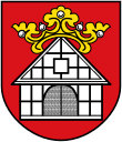
Blazon : "In red under a golden (yellow) crown set with silver (white) precious stones on the gable, a silver (white) house with black half-timbering and gate."
The coat of arms was designed by Kurt Schweder and never had an official character. At the end of the 1980s, the heraldist created coats of arms for all of Essen's districts. They have meanwhile been well received by the Essen population.
The crown and half-timbered house are symbols for the former royal court Ehrenzell, which as a gift from Emperor Otto I to the Essen monastery, retained royal protection and immunity.
See also
literature
- H. Westphalen: Pictures and memories from Essen-Altendorf . Klartext Verlag, Essen 2006.
- Helmut Scheffler: Settlement and economic development in the Altendorf district (Essen-West) . Term paper of the professional examination for the teaching post at secondary schools. Scientific Examination Office Bochum, 1970. 76 pp.
Web links
- Altendorfer Bürgererverein eV
- District portrait on the homepage of the city of Essen
Individual evidence
- ↑ Excerpt from the list of monuments of the city of Essen (PDF; 1.6 MB); accessed on April 25, 2019
- ↑ Essen.de: Altendorf district project - Potentials and approaches ( memento from October 19, 2014 in the Internet Archive ); Retrieved November 12, 2014.
- ^ City of Essen, population atlas accessed on April 25, 2019
- ↑ Social in Essen 6/2014 ( Memento from October 19, 2014 in the Internet Archive ) (PDF); accessed on September 14, 2014
- ↑ Essen.de: Altendorf district project - redesign of Ehrenzeller Platz ( memento from October 19, 2014 in the Internet Archive ); Retrieved November 12, 2014.
- ↑ Westdeutsche Allgemeine Zeitung of September 21, 2013: Neighbors storm new bridge
- ↑ Foundation stone laid for comprehensive school - pupil wishes for Bockmühle: Justice and participation ; In: Westdeutsche Allgemeine Zeitung of November 10, 1973
- ^ Rüdiger Hagenbucher: In Essen-Altendorf there is growing anticipation for the new comprehensive school building ; In: Westdeutsche Allgemeine Zeitung of December 6, 2019
- ↑ Excerpt from the list of monuments of the city of Essen (PDF; 421 kB); accessed on December 10, 2019
- ↑ Population figures of the districts
- ↑ Proportion of the population under 18 years of age
- ↑ Proportion of the population aged 65 and over
- ↑ Proportion of foreigners in the city districts
- ^ André Joost: Essen-Altendorf Operational Office Archive. In: NRWbahnarchiv. Retrieved June 23, 2017 .
- ↑ Stadtspiegel Westanzeiger from April 10, 2010, p. 4: Der Bunker
- ↑ Excerpt from the list of monuments of the city of Essen (PDF) accessed on December 10, 2019
- ↑ Excerpt from the list of monuments of the city of Essen (PDF) accessed on December 10, 2019
- ↑ Erwin Dickhoff: Essener streets, city history in the mirror of street names . 2nd Edition. Essen 1986


