Amboasary Sud
| Amboasary Sud | ||
|---|---|---|
|
|
||
| Coordinates | 25 ° 3 ′ S , 46 ° 23 ′ E | |
| Basic data | ||
| Country | Madagascar | |
| Toliara | ||
| region | Anosy | |
| ISO 3166-2 | MG-U | |
| District | Amboasary (District) | |
| height | 26 m | |
| surface | 248 km² | |
| Residents | 32,000 (2006) | |
| density | 129 Ew. / km² | |
|
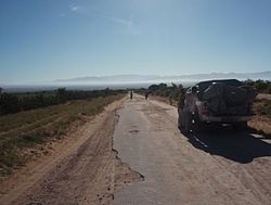
National Road 13 near Amboasary
|
||
Amboasary Sud or Amboasary Atsimo ( where orange trees grow ) is a rural community on Madagascar's south coast . It belongs to the Amboasary district and is located in the Anosy region .
Geography and population
Amboasary Sud administers an area of 248 square kilometers, on which in 2006 about 32,000 inhabitants lived, spread over 29 villages. The majority of the population of Amboasary consists of Tandroy , but there are also significant groups of Betsileo and Tanosy . The village is located on the national road 13 , which crosses the Mandrare river via a 400 meter long bridge from 1958 . The nearest larger towns are Ambovombe , 35 kilometers away, and Fort-Dauphin, 75 km away.
Economy and education
The economy of the place is determined by sisal plantings. The plantations and the factories in which the sisal fibers are extracted and processed are important employers in the region. In addition, sweet potatoes , cassava , corn , jojoba , sugar cane and onions are grown in Amboasary .
For tourism, the private are Berenty reserve with lemurs ( Katta , Sifakas ), the Bay of Italy ( Italy signifies in Malagasy: where the wind blows ) and the Anony lake with its flamingo colony and the caves of Jurassique Cirque interesting.
Amboasary Sud has 22 elementary and four middle schools.
Individual evidence
- ↑ a b c Jean-Michel Lebigre: Petite encyclopédie du Grand Sud de Madagascar . Presses Universitaires de Bordeaux / LGPA-éditions, Pessac 2016, ISBN 979-1-03000030-6 , p. 20 .

