
Ancash region
| Ancash region | |||
|---|---|---|---|
 .svg) |
|||
| Symbols | |||
|
|||
| Basic data | |||
| Country | Peru | ||
| Capital | Huaraz | ||
| surface | 35,914.4 km² | ||
| Residents | 1,148,600 (2015) | ||
| density | 32 inhabitants per km² | ||
| founding | June 12, 1835 | ||
| ISO 3166-2 | PE-ANC | ||
| Website | www.regionancash.gob.pe (Spanish) | ||
| politics | |||
| Gobernador regional | Juan Carlos Morillo Ulloa (2019-2022) | ||
 |
|||


Coordinates: 9 ° 30 ′ S , 77 ° 30 ′ W
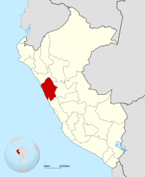
The region of Ancash [ ˈaŋkaʃ ] ( Spanish Región Ancash , Ancash-Quechua Ankash shuyu or Anqash shuyu ) is a Peruvian administrative region in the Andes . 1,148,600 (2015) people live in an area of 35,914.41 km². The capital is Huaraz . Chimbote is the most populous city in the region.
Surname
The name Ancash comes from Quechua and is derived either from anka ("eagle") or anqas ("blue").
geography
Ancash is located north of the Lima Provincias region on the Pacific Ocean and is bordered to the east by the Marañón River . The country is largely shaped by the Andes. The sub-mountains Cordillera Blanca and Cordillera Negra have a dozen mountains over 5000 meters, including the Huascarán , with 6768 meters the highest mountain in Peru. They are divided by the Callejón de Huaylas , the high valley of the Rio Santa . The Alpamayo (5947 m) was named the most beautiful mountain in the world in Munich in 1996.
In the Ancash region there are well - known pre-Columbian ruins such as B. Chavín de Huántar and Willkawain .
history
In the period between 900 and 300 BC The Chavin culture emerged and flourished in this region .
In the 15th century, the Santa Valley was incorporated into the Inca Empire by the ruler Pachacútec Yupanqui . The first Spaniards were attracted by the region's silver wealth. They destroyed the cities of the Incas and established the city of Huaraz .
On May 31, 1970, a strong earthquake shook the whole country. The city of Yungay was completely destroyed by a mudslide , killing 20,000 people.
population
The population of the Ancash region rose from 1,024,581 (1996) to 1,154,523 (2005) and, according to official government estimates, is distributed among the population's age structure as follows:
|
|
|
The Inca language Quechua (variant Ancashino ) is mostly spoken in Ancash, with twenty different dialects in this region alone.
Political structure
The Ancash region is divided into 20 provinces and 165 districts.
Web links
- Regional government of the Ancash region (Spanish)
- Population structure ( Memento of October 27, 2005 in the Internet Archive ) (Spanish)
Amazon | Ancash | Apurímac | Arequipa | Ayacucho | Cajamarca | Callao | Cusco | Huancavelica | Huánuco | Ica | Junín | La Libertad | Lambayeque | Lima | Loreto | Madre de Dios | Moquegua | Pasco | Piura | Puno | San Martín | Tacna | Tumbes | Ucayali
Lima Province (region-free area of the capital)