
Andratx
| Andratx municipality | |||
|---|---|---|---|
| coat of arms | Map of Spain | ||

|
|
||
| Basic data | |||
| Autonomous Community : | Balearic Islands | ||
| Island: | Mallorca | ||
| Comarca : | Serra de Tramuntana | ||
| Coordinates | 39 ° 34 ′ N , 2 ° 25 ′ E | ||
| Height : | 101 msnm | ||
| Area : | 81.45 km² | ||
| Residents : | 11,271 (Jan 1, 2019) | ||
| Population density : | 138.38 inhabitants / km² | ||
| Postal code : | 07150 | ||
| Municipality number ( INE ): | 07005 | ||
| Nearest airport : | Palma ( Son Sant Joan / Palma de Mallorca , 27 km ) | ||
| administration | |||
| Official language : | Catalan , Castilian | ||
| Mayor : | Jaume Porsell ( PP ) | ||
| Address of the municipal administration: | Av. de la Cúria, 1 07150 Andratx |
||
| Website : | www.andratx.cat | ||
| Location of the municipality | |||
Mallorca
|
|||

Andratx (pronounced: Andratsch ; Castilian Andraitx or Andrach ) is a municipality in the western part of the Balearic island of Mallorca . It has an area of 81.5 km² and 11,271 inhabitants (as of January 1, 2019). This corresponds to a population density of 138 people per km².
The population is concentrated in the capital of the same name off the coast and in the port of Port d'Andratx. Eight mountain peaks can be found here, with a height of 319 m ( Talaia des Cap des Llamp ) to 927 m ( Moleta de s'Esclop ).
geography
Places of the community
The municipality of Andratx includes the following places:
- Andratx (6444/6929 inhabitants)
- Es Camp de Mar (197/231 inhabitants)
- Port d'Andratx (2548/3033 inhabitants)
- Sant Elm (341/369 inhabitants)
- S'Arracó (521/786 inhabitants)
The population figures in brackets are from January 1, 2008. The first number corresponds to the residents of the built-up areas, the second number corresponds to the residents of the towns including the population outside the actual settlements. (Source: INE )

climate
In Andratx, rainfall is recorded all year round. The driest month is July with an average of 7.9 l / m². The highest amount of precipitation within 24 hours was recorded on September 17, 1988 in Sálqueria with 194.4 l / m².
history

The name Andratx in its current form is first mentioned in a document in 1236. There are, however, various theories about the actual origin of the name, but to this day none have been generally recognized or proven.
Ramon Rossello and Jaume Bover found that 25 different explanations of the name were recorded between the 13th and 19th centuries, ranging from the Celtic name Andraquis to the Arabic word indiraq . The men of the community are called andritxol , the women are called andritxole .
Since the island was ravaged by numerous North African pirates in the Middle Ages, it was necessary to build a defense system based on the construction of numerous towers. In the 16th century, J. Binimelis worked out a plan aimed at checking the locations of towers that had already been built and determining new locations. Of the total of 14 towers in the territory of the municipalities of Calvià and Andratx, 12 still exist today.
Population development
In 1785 Andratx had 4,090 inhabitants, in 1900 there were already 7,512 people. The lowest population with 4,303 was recorded in 1950. With 8,098 people in 1996, Andratx was 12th of the 53 municipalities in Mallorca.
| year | 1785 | 1842 | 1877 | 1887 | 1900 | 1910 | 1920 | 1930 | 1940 | 1950 | 1960 | 1970 | 1981 | 1991 | 2001 | 2011 |
|---|---|---|---|---|---|---|---|---|---|---|---|---|---|---|---|---|
| Residents | 4,090 | 4,609 | 7,022 | 7,415 | 7,512 | 7,413 | 7,087 | 6,887 | 5,569 | 4,303 | 4,404 | 5,890 | 6,301 | 6,897 | 7,753 | 11,919 |
In 2006 the proportion of foreigners was 29.6% (3,081), the proportion of German residents was 11.9% (1241 people).
Culture and sights
- Port d'Andratx harbor
- Sandy beaches (Platja) Sant Elm , Sa Dragonera Island , Camp de Mar
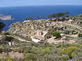
- The former monastery La Trapa at 270 m above sea level. At this point, Trappists expelled from France founded a monastery in 1810, which they had to leave after fourteen years because it was closed by the state. Some of the building remains have been preserved. The gardens with terraces can still be seen, and the remains of the mighty baobab tree, once the largest in Mallorca, stand next to the ruins of the monastery.
- The hike from Port d'Andratx via Sant Elm to La Trapa is the first stage of the GR 221 long-distance hiking trail .
- Centro Cultural Andratx , the gallery is one of the larger centers of contemporary art in Europe. La Asociación Sa Taronja , on the west side of the city, is one of the few independent cultural centers on the island.
- Studio Weil

Port d'Andratx harbor

Sa Dragonera

Camp de Mar
Sa Trapa monastery (ruin)


Festivals
To be celebrated (fiestas)
- Sant Cristofol in the first week of July,
- Verge del carme (Port d'Andratx) on July 15th and 16th,
- Sant Agusti (S'Arraco) on August 28th,
- Nuestra Señora de la Trapa on September 8th in (S'Arraco).
market
There are markets on Wednesdays at Pasatge de Son Mas and Saturdays in S'Arracó on the main square.
panorama

Web links
- Municipal administration website (Catalan)
- Data sheet. Informació de l'Institut d'Estadística de les Illes balears
Individual evidence
- ↑ Cifras oficiales de población resultantes de la revisión del Padrón municipal a 1 de enero . Population statistics from the Instituto Nacional de Estadística (population update).
- ^ R. Rossello and J. Bover (1992): El Sexe a Mallorca: Notes Historiques, Palma de Mallorca
- ↑ La Trapa. (PDF; 1.1 MB) gobmallorca.com, archived from the original on June 17, 2012 ; accessed on February 28, 2010 (German).