
Arolla
| Arolla | ||
|---|---|---|
| State : |
|
|
| Canton : |
|
|
| District : | Hérens | |
| Municipal municipality : | Evolène | |
| Postal code : | 1986 | |
| Coordinates : | 603 428 / 96921 | |
| Height : | 2006 m above sea level M. | |
| Website: | www.arolla.com | |
 Arolla |
||
| map | ||
|
||

Arolla is a place in French-speaking Switzerland . It belongs to the municipality of Evolène in the district of Hérens in the canton of Valais .
location

Arolla is located at 1998 m above sea level. M. in the upper valley end of the Val d'Hérens , approx. 3.5 km north of the Arolla glacier system around the Mont Collon ( 3637 m above sea level ). The surrounding mountain peaks are at 3,600 to 4,000 m, to the northwest is the Aiguilles Rouges d'Arolla ( 3646 m above sea level ), well-known peaks in the southwest are the Pigne d'Arolla ( 3796 m above sea level ), the Mont Blanc de Cheilon ( 3870 m above sea level ) and La Ruinette ( 3875 m above sea level ). The border with Italy runs south of this glaciated mountain range of the Valais Alps .
The south-westerly headwaters of the Borgne , the Borgne d'Arolla , originate in the lower Arolla Glacier , and at Les Haudères it unites with the Borgne de Ferpècle , which flows in from the southeast and rises in the Ferpècle Glacier .
The place
The settlement, which was already occupied in the Middle Ages, was discovered by alpinists in the 19th century. The Hotel Mont Collon was built by Jean Anzévui in 1865, the Grand Hôtel et Kurhaus (Jean Gaspoz) in 1898, the Hôtel du Pigne in 1911 by Antoine Métrailler, the Hotel Victoria in 1912 (today Aiguille de la Tsa , builder: Antoine Forclaz and the Follonier brothers ) and in 1935 the Hôtel du Glacier (Jean Anzévui). After the construction of the access road by the Grande Dixence power plant company in the early 1960s, Arolla became better known as a tourist destination: holiday apartments and ski lifts were built. Today, the idyllic place, away from mass tourism, is visited in summer by hikers, mountaineers and in winter by skiers, ski tourists, cross-country skiers and snowshoe hikers. In 1963 a pumping station was built in the headwaters of the Borgne d'Arolla (hiking car park to the glaciers), which ties the brook into the 420 km² catchment area of the world's fifth-highest dam, the Grande Dixence; this hydropower plant with a 100 km underground network of tunnels collects water from over 50 glaciers between the Mischabel group and Mont Gelé . The supply tunnel from Arolla to the 24 km long main line is 312 m long.
Driveway
Until the middle of the 20th century, Arolla was only accessible from Les Haudères on a mule track; In 1959 the route was only accessible by jeep.
The power station company "Grande Dixence" built a new road to La Gouille in 1960 and from there expanded the road for trucks. In 1968 the road was opened for the first time in the winter season; In the following years numerous galleries were built to protect the street from avalanches.
Arolla can be reached in around eighty minutes by post bus from Sion .
post Office
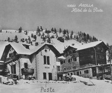
The postal history of Arolla begins around 1900: At that time, the local hoteliers asked the Lausanne district post office whether they could open a postal depot in the village. As a result, a small post office is set up in June of the same year. At that time it was administered by Pierre Fauconnet, who also ensured the mail traffic between Arolla and the village of Haudères. As tourism increased rapidly, the connection quickly gained in importance. The mail between the two places was transported on the back of mules until 1950. This year a road was built, since then faster mail traffic has been ensured.
The first actual post office, which had the status of a post office from 1921, was located between 1910 and 1965 in a building called the “Bazar de la Poste”. Due to the further development - above all winter tourism - post holder Joseph Pralong opened a new, larger post office in 1965. At the same time, the new telephone and telegraph stations were inaugurated. The Arolla post office is one of the highest post offices in Switzerland.
Summer sports

In summer Arolla is known as a starting point for mountain hikes and climbing tours.
- Lac Bleu and Cabane des Aiguilles Rouges
- Lac des Dix and Cabane des Dix
- Lower and Upper Arolla Glacier with glacier crossings and ascents.
- Long-distance hike: Tour du Cervin (around the Matterhorn in about a week)
- Long-distance hike: Tour du Val d'Hérens
- Stage of the world-famous Haute Route from Zermatt to Chamonix
Winter sports
The ski areas range from 2000 to 3000 m. Arolla has 5 ski lifts and 47 km of ski slopes. The well-known ski racer Chantal Bournisse was born in Arolla.
Arolla is a stage on the famous Haute Route from Zermatt to Chamonix and the starting point for numerous ski tours.
For cross-country skiers, the “most beautiful trail in central Valais” is groomed from December to around Easter. It leads from Satarma via Arolla to the end of the lower Arolla glacier along the Borgne river (approx. 10 km).
Web links
- Official website of the village of Arolla
- Danielle Allet-Zwissig: Arolla. In: Historical Lexicon of Switzerland .
- Arolla on the ETHorama platform
Individual evidence
- ↑ Post structures - PTT archive. Retrieved September 1, 2019 .
- ↑ Cabane des Aiguilles-Rouges. Association de la Cabane des Aiguilles-Rouges, accessed June 26, 2014 (French).