
Ayamonte
| Ayamonte municipality | |||
|---|---|---|---|

|
|||
| coat of arms | Map of Spain | ||

|
|
||
| Basic data | |||
| Autonomous Community : |
|
||
| Province : | Huelva | ||
| Comarca : | Costa Occiental | ||
| Coordinates | 37 ° 13 ′ N , 7 ° 24 ′ W | ||
| Height : | 63 msnm | ||
| Area : | 142 km² | ||
| Residents : | 20,946 (Jan. 1, 2019) | ||
| Population density : | 147.51 inhabitants / km² | ||
| Postal code : | 21,400 | ||
| Municipality number ( INE ): | 21010 | ||
| administration | |||
| Mayor : | Alberto Fernández Rodríguez. | ||
| Address of the municipal administration: | Plaza de la Laguna, 1, 21400 Ayamonte, tel: +34 959 47 03 42 | ||
| Website : | ayto-ayamonte.es | ||
| Location of the municipality | |||

|
|||

Ayamonte is a Spanish city in the province of Huelva in the autonomous region of Andalusia . On January 1, 2019, there were 20,946 inhabitants. The urban area has an area of 142 km² and a population density of 148 inhabitants / km². The place is at the mouth of the Guadiana River in the Atlantic Ocean and thus on the border with Portugal . It is 48 km to the provincial capital Huelva and 140 km to Seville .
history
In Roman times, the mouth of the Guadiana River was known as Ostium Fluminis Anae . From there an important trade route led north to Mérida . It is believed that Ayamonte already played a strategically important position at this time.
In 1239 the Moorish rule was ended by the troops of King Sancho II of Portugal and the place was placed under the Santiagoorden . In 1263 the Guadiana was established as the border between Portugal and Spain and the town came under the sovereignty of the Castilian crown. At first it belonged to the County of Niebla , but later formed its own margraviate .
In 1664 it was granted city rights by King Philip IV .
traffic
The place is a few kilometers south of the Spanish A-49 motorway. Since 1991 the Puente Internacional del Guadiana has connected the city with the Portuguese side of the river. A small car ferry offers an alternative way to get to Vila Real de Santo António .
politics
| Political party | 2011 | 2015 | ||
|---|---|---|---|---|
| Be right % | Seats | Be right % | Seats | |
| PP | 35.64% | 8th | - | - |
| PSOE | 45.70% | 10 | - | - |
| IULV-CA | 7.47% | 1 | - | - |
| PA (local) | 8.51% | 2 | - | - |
Source:
Population development

Attractions
- Ermita de San Sebastián - The chapel was built from quarry stone at the end of the 16th century.
- Iglesia de las Angustias parroquial - The most important church in the city was built in the 16th century and has Mudejar - and Renaissance -Stilelemente on. The patroness of Ayamonte is also located here.
- Convento de Santa Clara - A monastery complex from the 19th century.
- Templo de la Merced - The monastery church was built in the early 17th century. Worth mentioning is the altarpiece in the Baroque style .
- Parroquia del Salvador - The parish church was built around 1400 on the remains of a mosque ; in a mixture of different styles.
- Torre de Canela - A fortress tower from the 16th century on the road to the beach.
- Casa Grande - built in the style of Cadiz town houses at the end of the 18th century. Seat of the city library and the cultural office.
- Palacio de los Marqueses de Ayamonte - Former residence of the Marquis of Ayamonte.
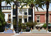
- Plaza de la Laguna - The city's main square, where the town hall is also located.
- El Pintado tide mill

View from the Plaza de España

Plaza de la Laguna
On the Paseo de la Ribera

Parish Church of Iglesia de las Angustias
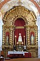
High altar in the Templo de la Merced

Bridge over the Guadiana


sons and daughters of the town
- Antonio León Ortega (1907–1991), sculptor
- Florencio Aguilera (1947), painter, art collector and music organizer
- María Isabel (1995), singer
Town twinning
Web links
- Ayamonte info information about the city (Spanish)
- Official website for tourism in Spain general information about Ayamonte
Individual evidence
- ↑ Cifras oficiales de población resultantes de la revisión del Padrón municipal a 1 de enero . Population statistics from the Instituto Nacional de Estadística (population update).
- ^ Spanish Ministry of the Interior
- ^ INE archive
Alájar | Aljaraque | El Almendro | Almonaster la Real | Almonte | Alosno | Aracena | Aroche | Arroyomolinos de León | Ayamonte | Beas | Berrocal | Bollullos Par del Condado | Bonares | Cabezas Rubias | Cala | Calañas | El Campillo | Campofrío | Cañaveral de León | Cartaya | Castaño del Robledo | El Cerro de Andévalo | Corteconcepción | Cortegana | Cortelazor | Cumbres de Enmedio | Cumbres de San Bartolomé | Cumbres Mayores | Chucena | Encinasola | Escacena del Campo | Fuenteheridos | Galaroza | Gibraleón | La Granada de Río-Tinto | El Granado | Higuera de la Sierra | Hinojales | Hinojos | Huelva | Isla Cristina | Jabugo | Lepe | Linares de la Sierra | Lucena del Puerto | Manzanilla | Los Marines | Minas de Riotinto | Moguer | La Nava | Nerva | Niebla | La Palma del Condado | Palos de la Frontera | Paterna del Campo | Paymogo | Puebla de Guzmán | Puerto Morale | Punta Umbría | Rociana del Condado | Rosal de la Frontera | San Bartolomé de la Torre | San Juan del Puerto | San Silvestre de Guzmán | Sanlúcar de Guadiana | Santa Ana la Real | Santa Bárbara de Casa | Santa Olalla del Cala | Trigueros | Valdelarco | Valverde del Camino | Villablanca | Villalba del Alcor | Villanueva de las Cruces | Villanueva de los Castillejos | Villarrasa | La Zarza-Perrunal | Zalamea la Real | Zufre