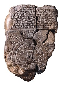
Babylonian world map
The Babylonian world map is a schematic representation of the world from the perspective of the Babylonians at the time of the New Babylonian Empire . It shows a disk of earth surrounded by water through which the Euphrates flows. The unique representation gives clues to the Babylonian worldview .
The world map is carved on a clay tablet that was found in Sippar . It is dated to 700–500 BC. And is now in the British Museum (cat.-no. 92687).
| 1. Mountain (šá-du-ú) 2. City (uru) 3. Urartu (ú-ra-áš-tu) 4. Assyria ( kur aš + šur ki ) 5. Dēr 6.? 7. Swamp (ap-pa-ru) 8. Elam (šuša) 9. Canal (bit-qu) 10. Bit Jakin 11. City (uru) 12. Habban 13. Babylon (tin.tir ki ), flowed through by the Euphrates 14.-17. Ocean (bitter water) ( id mar-ra-tum) 18. – 22. Mythological objects 23. – 25. not described |
The general idea of the land surrounded by the sea persisted into the Greek era (for example in Anaximander of Miletus , Hecataus of Miletus ).
literature
- Wayne Horowitz: The Babylonian Map of the World. In: Iraq 50, 1988, pp. 147-165.
- Friedhelm Hartenstein : The Babylonian world map, in: C. Markschies u. a. (Ed.), Atlas of World Views. Berlin 2011. pp. 12-21.

