Bago
| ပဲခူး Bago |
||
|---|---|---|
|
|
||
| Coordinates | 17 ° 20 ′ N , 96 ° 29 ′ E | |
| Basic data | ||
| Country | Myanmar | |
| Bago region | ||
| District | Bago | |
| ISO 3166-2 | MM-02 | |
| Residents | 245,000 (2005) | |
Bago ( Burmese Paigu, pronunciation: [ bəgó ]) is the fourth largest city in Myanmar and the capital of the administrative unit of the same name, Bago Division . The spelling Pegu is also known from the colonial era.
Bago is located about 80 km north of Rangoon in the southeast of the Bago Division on the Bago River, which flows into the Indian Ocean . The estimated population on January 1, 2005 was 245,000.
history
Bago was once the capital of the Pegu Empire (in the Mon language: Hongsawatoi , Burmese Hanthawaddy ), which was founded by the Mon in the 9th century . Bago itself dates from the year 825. In 1369 it became the capital of an independent kingdom of the Mon. This flourished around 1500 and gained prosperity and influence mainly through overseas trade.
In 1593 it was conquered by the Burmese King Tabinshwehti of Taungu . He immediately moved his capital to the strategically located Pegu, from where he led further campaigns of conquest, including against the Siamese kingdom of Ayutthaya . Under Tabinshwehti's successor Bayinnaung , Pegu became the center of a vast but short-lived empire. After Bayinnaung's death, Pegus' sphere of influence quickly shrank until it collapsed completely in 1599. The capital was conquered and sacked by Arakan's troops in conjunction with Portuguese mercenaries.
King Anaukpetlun , who reunited Burma in 1613, and his successors ruled from Ava , not Pegu. With the decline of the influence of the kings of the Taungu dynasty in Ava, the Mon rebelled in Pegu and again established their own kingdom in Pegu / Hongsawatoi in 1740. The city was completely destroyed by the Burmese under King Alaungpaya in 1757 . At that time it had about 150,000 inhabitants. Reconstruction began in 1790. As a result of the Second Anglo-Burmese War , sub-companies, including Pegus, came to the British colonial empire. In 1891 the city again had more than 10,000 inhabitants.
The numerous wars between the Burmese and the Mon as well as between the Burmese and the Siamese ( Thai ) led to the fact that today there are hardly any buildings left. The numerous earthquakes also took their toll, with the earthquakes in 1912, 1917 and 1930 once again destroying outstanding monuments.
Attractions
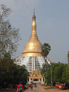
The most important building today is the Schwemadaw Pagoda , which is said to house relics of the Buddha . It was also built as early as 825, but later significantly expanded, u. a. of King Bodampaya . The gay pagoda is also very much revered. The Mahazedi Pagoda from the 16th century, was completely destroyed in 1930 but rebuilt again. One kilometer west of the station is the second largest reclining Buddha, the Shwethalyaung Buddha .
The Kyaikpun Pagoda is located four kilometers south of Bago . It was built in 1476 by King Dhammazedi and consists of a high pillar with a square plan, the four sides of which are adorned by 30 m high statues. They show Buddha and his predecessors.
Personalities
- Wilhelm Freiherr von Danckelmann (1741–1782), Crown Fiscal Authority of the Dutch possessions in Asia, was shipwrecked off the coast and had a fatal accident

