Balderschwang
| coat of arms | Germany map | |
|---|---|---|

|
Coordinates: 47 ° 28 ' N , 10 ° 6' E |
|
| Basic data | ||
| State : | Bavaria | |
| Administrative region : | Swabia | |
| County : | Oberallgäu | |
| Management Community : | Group of horns | |
| Height : | 1044 m above sea level NHN | |
| Area : | 41.66 km 2 | |
| Residents: | 366 (Dec. 31, 2019) | |
| Population density : | 9 inhabitants per km 2 | |
| Postal code : | 87538 | |
| Area code : | 08328 | |
| License plate : | OA | |
| Community key : | 09 7 80 113 | |
| LOCODE : | DE BM7 | |
| Community structure: | 12 parts of the community | |
| Address of the municipal administration: |
Balderschwang 11 87538 Balderschwang |
|
| Website : | ||
| First Mayor : | Konrad Kienle ( CSU ) | |
| Location of the municipality of Balderschwang in the Oberallgäu district | ||

Balderschwang is a municipality and a parish village in the Swabian district of Oberallgäu . In terms of population, Balderschwang is the second smallest municipality in Bavaria after Chiemsee , and also the municipality with the highest town center in Germany ( 1044 m above sea level ). Balderschwang is a member of the Hörnergruppe administrative association based in Fischen im Allgäu .
geography
Geographical location
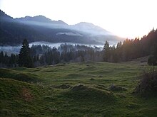
Balderschwang is located in the Balderschwanger Tal , a high valley in the Allgäu Alps . Geographically, the place belongs to the Bregenzerwald , which was more distinctive than the Allgäu for centuries due to its much easier access. The border with Austria runs along the entire western municipal boundary and to the outskirts. In the east rises the Riedberger Horn ( 1787 m above sea level ), the highest point of the Central Allgäu Horn group . Balderschwang is a member of the German-Austrian joint project Naturpark Nagelfluhkette .
The hamlet of Hirschgund , located eight kilometers to the south, with the Hirschgund Valley running from east to west, also belongs to the community . Hirschgund is separated from the rest of the municipality by a mountain range and is only connected to the road network via the area of the Austrian municipality of Sibratsgfälle and via a private road from Oberstdorf.
Parish parts
Balderschwang has 12 officially named municipal parts (the type of settlement is given in brackets ):
|
|
climate
With an average of 2,450 liters per square meter per year, Balderschwang is the place with the highest rainfall in Germany. Balderschwang is also the record holder for the highest annual rainfall in Germany with 3503.1 liters per square meter (1970).
history
Until the 19th century
The place name goes back to a farmer named Balder who is said to have cleared the valley in the 14th century. 1451/1523 came the Balderschwang area with the county of Bregenz to Habsburg and Austria . Only after the Little Ice Age of the 16th to 18th centuries Permanent settlement began in the 19th century. Balderschwang was inhabited all year round for the first time in 1684 by a monastic alpine administrator from Weingarten . Until the 18th century, Balderschwang was mainly used as an alpine village for the deeper forest locations. Around 1800 there were 16 families in the valley who produced around 1,400 tons of cheese a year. In 1805 Balderschwang and Vorarlberg came to the Kingdom of Bavaria in the Peace of Pressburg . In 1814 the entire Bregenzerwald returned to Austria, only Balderschwang stayed with Bavaria for unexplained reasons when the border was drawn. For this reason in Balderschwang predominantly "forest" as part of the Vorarlberg dialects is spoken to this day.
20th century
Since the completion of the road over the Riedbergpass 1961 and the direct connection to the Oberallgäu also spreads recently Oberallgäuerisch out. Both idioms belong to Lake Constance Alemannic .
Population development
From 1988 to 2008 Balderschwang's population increased by 40 or 19%. Between 1988 and 2018 the municipality grew from 206 to 353 by 147 inhabitants or 71.4% - the strongest percentage growth in the Oberallgäu district in the period mentioned.
The following figures refer to the territory on May 25, 1987.
| Population development | ||||||||||||||
|---|---|---|---|---|---|---|---|---|---|---|---|---|---|---|
| year | 1840 | 1900 | 1939 | 1950 | 1960 | 1970 | 1987 | 1991 | 1995 | 2000 | 2005 | 2010 | 2015 | 2017 |
| Residents | 192 | 104 | 126 | 225 | 202 | 192 | 196 | 224 | 209 | 200 | 213 | 252 | 327 | 363 |
politics
Municipal council
In addition to the mayor, the municipal council has eight members:
| CSU | independent | total | |
| 2020 election results | 8th | - | 8 seats |
| Election result 2014 | 7th | 1 | 8 seats |
| 2008 election results | 6th | 2 | 8 seats |
| 2002 election results | 8th | - | 8 seats |
mayor
In March 2014, the innkeeper Konrad Kienle (CSU) was elected to succeed Werner Fritz (non-party) and was confirmed on March 15, 2020 with 94.5% of the votes for another six years. Fritz had held the office for 12 years.
badges and flags
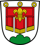
Description: A three-lobed red flag with golden fringes and three golden rings, on which a golden heraldic lily is applied, in silver over a green three-mountain.
The flag commemorates the Counts of Montfort, who owned the municipality from 1311 to the 16th century.
The red-yellow-green municipal flag approved at the same time is not used.
Culture and sights
Natural monuments
The old yew of Balderschwang is located about 1 km northeast of the town center in an alpine area . The age of this female yew is estimated to be 800–1,500 years. The age specification on site with up to 4,000 years is unrealistic. It stops at 1,150 m above sea level. NN on calcareous Nagelfluhboden . Its trunk is divided into two parts and despite its old age it bears abundant fruit every year. At a low height of about 7 m, both trunk parts, including the missing middle section, reach a circumference of over 8 m at chest height, which is enormous for yew trees. There are other old yew trees of smaller dimensions in the area.
Architectural monuments
Economy and Infrastructure
Agriculture
In the past, cheese production was Balderschwang's main source of income. However, annual production fell from 1,400 tons in the 18th century to 300 tons in the early 21st century.
tourism
Today the place lives mainly from tourism . The 1,196 guest beds in 2010 recorded 39,874 guests and 177,233 overnight stays.
traffic
Until the opening of the highest German pass road over the Riedbergpass ( 1407 m above sea level , since 1961), Germany could only be reached by car via Austria for the Balderschwanger .
Ski Area
With around 40 kilometers of slopes, the Balderschwang ski area is one of the largest ski areas in Germany.
media
The church radio station Radio Horeb , which can be received in the Munich area via VHF and throughout Germany via DAB + , is based in Balderschwang. The head of the station, Richard Kocher, is also the local Catholic pastor.
literature
- Thilo Ludewig: Balderschwang yesterday and today (available from the spa administration)
Sons and daughters of the church
- Johann Konrad Dorner (1809–1866), painter of the Nazarene style, especially in St. Petersburg
- Bert Poensgen (1947–2017), motorcycle sports manager and operator of the Bodenseehütte
Web links
- Website of the Balderschwang community
- Entry on Balderschwang's coat of arms in the database of the House of Bavarian History
Individual evidence
- ↑ "Data 2" sheet, Statistical Report A1200C 202041 Population of the municipalities, districts and administrative districts 1st quarter 2020 (population based on the 2011 census) ( help ).
- ↑ Balderschwang. Administrative association Hörnergruppe, accessed on May 27, 2020 .
- ^ Community Balderschwang in the local database of the Bavarian State Library Online . Bavarian State Library, accessed on August 15, 2019.
- ↑ http://www.dw-world.de/dw/article/0,2144,765495,00.html
- ↑ http://www.dwd.de/bvbw/appmanager/bvbw/dwdwwwDesktop?_nfpb=true&_pageLabel=dwdwww_result_page&portletMasterPortlet_i1gsbDocumentPath=Navigation%2FOeffentlichkeit%2FKlima__Umwelt%2FWetterrekorde%2Fniederschlag__node.html%3F__nnn%3Dtrue
- ↑ DPA-RegiolineGeo: Elections: In Balderschwang, the CSU drives a dream result. In: Focus Online . March 16, 2014, accessed October 14, 2018 .
- ^ Entry on Balderschwang's coat of arms in the database of the House of Bavarian History
- ↑ Entry on Balderschwang on the website kommunalflaggen.eu
- ↑ skigebiet-balderschwang.de: History of the ski area
- ↑ Reception of the radio via DAB + ( memento of the original from December 19, 2012 in the Internet Archive ) Info: The archive link was automatically inserted and has not yet been checked. Please check the original and archive link according to the instructions and then remove this notice. . Radio Horeb website. Retrieved August 14, 2011.


