
Lower Normandy
|
Lower Normandy Former French Region (until 2015) |
|

|

|
  |
|
| Basic data | |
|---|---|
| Today part of | Normandy |
| Administrative headquarters | Caen |
|
population
- total January 1, 2017 |
1,474,257 inhabitants |
|
surface - total |
17,589 km² |
| Departments | 3 |
| Arrondissements | 11 |
| Cantons | 141 |
| Communities | 1,812 |
| Formerly ISO 3166-2 code | FR-P |
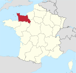
The Lower Normandy [ bɑsnɔʀmɑdi ] ( Lower Normandy ) was a region in the north of France , consisting of the departments of Calvados , Manche and Orne consisted. It had an area of 17,589 km² and 1,474,257 inhabitants (as of January 1, 2017). The capital of the region was Caen . On January 1, 2016, Lower Normandy merged with Upper Normandy to form the Normandy region . The provisional capital of the new region is Rouen .
geography


The region lies on the English Channel , into which the Cotentin peninsula protrudes. In the west it borders at Mont-Saint-Michel on Brittany , in the south on the Pays de la Loire and in the east on the Seine estuary on Haute-Normandie ("Upper Normandy").
coat of arms
Description: In red, two blue-tongued and thus armored golden, walking leopards .
history
The name Normandy for the region goes back to the fact that the historical sites of the Normans are located here, from where William the Conqueror conquered England in 1066 ( Battle of Hastings ).
This is where the Allied landings on the beaches of Omaha- and Utah Beach , as well as Gold , Juno and Sword , and also the parachute jump in Sainte-Mère-Église and Bénouville took place on June 6, 1944 , with which the liberation of France and Europe started by National Socialism .
The region of Lower Normandy was formed in 1956 when historical Normandy was divided into two regions, Lower Normandy and Upper Normandy, when France was divided into program regions . On January 1, 2016 , the region of Lower Normandy merged with the neighboring region of Upper Normandy to form the new region of Normandy.
Cities
The most populous cities in Lower Normandy are:

| city | Inhabitants (year) | Department |
|---|---|---|
| Caen | 105,354 (2017) | Calvados |
| Cherbourg-en-Cotentin | 79,200 (2017) | Some |
| Alencon | 25,848 (2017) | Orne |
| Hérouville-Saint-Clair | 22,954 (2017) | Calvados |
| Lisieux | 20,318 (2017) | Calvados |
| Saint-Lô | 19,116 (2017) | Some |
| Flers | 14,734 (2017) | Orne |
| Argentan | 13,823 (2017) | Orne |
Political structure
The region of Lower Normandy is divided into three departments :
| Department | prefecture | ISO 3166-2 | Arrondissements | Cantons | Communities | Inhabitants (year) | Area (km²) |
Density (inh / km²) |
||
|---|---|---|---|---|---|---|---|---|---|---|
| Calvados | Caen | FR-14 | 4th | 25th | 538 |
|
5,548 | 125.1 | ||
| Some | Saint-Lô | FR-50 | 4th | 27 | 477 |
|
5,938 | 83.7 | ||
| Orne | Alencon | FR-61 | 3 | 21st | 394 |
|
6.103 | 46.4 |
economy
.jpg)
When compared with the GDP of the European Union expressed in purchasing power standards , the region achieved an index of 89.4 in 2006 (EU-27 = 100).
The best known products of Lower Normandy are the raw milk cheese varieties Camembert , Pont-l'Évêque , Livarot and drinks cider , perry (pear cider), Pommeau and Calvados .
tourism
On January 3, 1987, a law was passed in France that the regional councils (frz. Conseil régional) of the French regions should set up so-called “Comité Régional de Tourisme” (German tourism association of a region). The task of the "Comité Régional de Tourisme de Normandie" (German Tourism Association of Normandy) is to market Normandy as a holiday destination at home and abroad. The specialty of this tourism association is that two administrative regions ( Upper and Lower Normandy) pool their resources and their commitment in order to promote the Normandy region together. In addition to marketing, market analyzes and the improvement of the tourist offer in cooperation with the Norman service providers are also important tasks of this organization.
Attractions

- Pirou Castle
- Jardin des Plantes of Coutances
- Lessay
- Mont-Saint-Michel
- La Cité de la Mer
- Park and garden of the Château de la Motte
- Marais du Cotentin et du Bessin Regional Nature Park
- Tatihou
- Train Touristique du Cotentin
- Tumulus of Colombiers-sur-Seulles
See also
Web links
- Lower Normandy Region (French)
- Prefecture of the Lower Normandy Region (French)
- Basse-Normandie: Marked by memories, France's official website (German)
Individual evidence
- ↑ Eurostat press release 23/2009: Regional GDP per inhabitant in the EU27 (PDF file; 360 kB)
Coordinates: 49 ° 0 ′ N , 0 ° 23 ′ W
Collectivités :
Auvergne-Rhône-Alpes |
Bourgogne-Franche-Comté |
Brittany |
Center-Val de Loire |
Grand Est |
Hauts-de-France |
Île-de-France |
Normandy |
Nouvelle-Aquitaine |
Occitania |
Pays de la Loire |
Provence-Alpes-Cote d'Azur
Collectivité with special status:
Corsica
Overseas Regions (ROM) :
French Guiana |
Guadeloupe |
Martinique |
Mayotte |
Reunion
Former regions (disbanded 2015):
Aquitaine |
Auvergne |
Burgundy |
Champagne-Ardenne |
Alsace |
Franche-Comté |
Languedoc-Roussillon |
Limousin |
Lorraine |
Midi-Pyrénées |
Nord-Pas-de-Calais |
Lower Normandy |
Upper Normandy |
Picardy |
Poitou-Charentes |
Rhône-Alpes