Batina
| Batina | ||
|
|
||
| Basic data | ||
|---|---|---|
| State : |
|
|
| County : |
|
|
| Municipality : | Općina Draž | |
| Telephone code : | (+385) 031 | |
| Postal code : | 31 306 | |
| License plate : | OS | |
| Structure and administration | ||
| Community type : | settlement | |
 Batina |
||
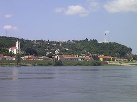
Batina is a place in Croatia with 1,449 inhabitants in the Osijek-Baranja County ( Osječko-baranjska županija ), 105 m high on a hill on the Danube 25 km northeast of Osijek in the border triangle of Croatia, Serbia and Hungary on the M 17.1, Osijek- Batina-Bezdan, located.
The border town has a Danube port. A bridge built in 1974 connects Croatia and the Serbian Bezdan on the other bank . Batina is dominated by agriculture, but since the end of the war tourism has developed into a second mainstay of the community, in particular through the recreation and leisure center "Zeleni Otok" ("Green Island"), which offers swimming and water sports and is also the center of an artists' colony .
The first traces of settlement on the Gradac hill point back to the Bronze and Iron Ages ; the Ad Militare fort existed here from the 1st century AD until late antiquity . Worth seeing are the baroque chapel from 1756 on the banks of the Danube (left in the picture), the wine cellars carved into the rock and a 29 m high monument that crowns the hill (right in the picture). The memorial with a permanent exhibition was erected in memory of the Battle of Batina from November 6th to 29th, 1944, in which Soviet and Yugoslav units jointly defeated the German troops.

