
Fortifications of the city of Salzburg
| Fortifications of the city of Salzburg | |
|---|---|
| place | Salzburg |
| builder | Santino Solari (3rd fortification) |
| architect | Santino Solari (3rd attachment) |
| Client | Prince Archbishop Paris of Lodron (3rd fortification) |
| Architectural style | Early baroque (3rd attachment) |
| Construction year | 1620–1645 (3rd attachment) |
| demolition | after 1861 |
| height | 3. Attach. outside city mountains up to 15 m |
The fortifications of the city of Salzburg secured the old royal seat and its inhabitants for many centuries. On both sides of the Salzach , a closed ring of walls (partly also in the form of vertically hewn rocks) led around today's old town , which also included the fortress Hohensalzburg . The fortification of the city, which was laid out in three stages with a long time lag, only lost its defensive importance in 1860 and was largely demolished a few years later.
The first city fortifications (11th / 12th to 13th centuries)
The old town on the right
The first city wall of the right-hand old town enclosed only a small area around the bridgehead of the main bridge. On the side of the Salzach axis, the defensive wall ran from the Lederertor to the Inner Steintor. The further course led from the northern line of the Lederergasse over the Sauterbogen to the northern line of the Königsgässchen and from there to the Ostertor (later Inneres Ostertor) and from there to the western foothills of the Kapuzinerberg to the Trumpeter Castle (today the church of the Capuchin monastery ) and from there over steep rock walls to the inner stone gate.
The old town on the left
The fortification of the old town on the left led from the Westertor (later Gstättentor or Schleifertor) and from there along the northern row of houses on Getreidegasse to the oldest bridge gate (presumably in today's area, Judengasse 3). From there the defensive wall train led in the area of today's north-eastern row of houses on Webergasse ( Pfeifergasse ) to Kumpfmühltor and from here to Nonntaltor.
Festungsberg and Mönchsberg

On the Nonnberg , the southern foothills of the fortress mountain , the defensive wall led steeply up to the monastery area and from there via the outer Nonnbergtor to the main castle (today fortress Hohensalzburg ). From the fortress the defensive wall led along the steep Südabbruches the Mönchsberg over the saddle over an existing there gate and the Red Tower to the towers of the kennel in the southwest of the mountain (now Richterhöhe ) and from there to the area of vigilante where the attachment already at that time separated the mountain in two parts to end at the steep rocky eruptions directly above the Klausentor.
Preserved parts of the fortifications
Remains of the city wall have been preserved in individual old town houses (e.g. the basement of the town hall or in the Sternbräu); The fortified towers on the Mönchsberg are the Red Tower (today heavily changed as Freyschlösschen ) and the Konstantin Tower ( derelict) from the late 13th century, as well as other defensive towers (Abtsturm, Barbaraturm, Michaelsturm, Josefsturm, Bertoldsturm) from the 14th century. Parts of the defensive walls next to the Benedictine monastery Nonnberg , the remains of the city wall in the courtyard of the houses Lederergasse 1 and 3 and the defensive wall west of the Franziskuspforte including the preserved battlements ( Linzer Gasse 14) have also been preserved .
The second city fortification (1465 to 1480)
Extensions and reinforcements on the right side of the old town
.png)
As early as the 14th and 15th centuries, additional city gates were introduced to the two important city gates (Ostertor and Steintor) to better secure the city. At that time, the first Bergstrasse gate was probably built on the road to Bergheim. After 1460, the entire space between today's Dreifaltigkeitsgasse , Paris-Lodron-Strasse and Wolf-Dietrich-Strasse was included in the new city fortifications. As a strong fortification to the northeast, the Hexenturm was built as a corner tower , a similar tower, which had long since been demolished, existed in the area of today's north wing of the Lodronschen Primogeniturpalast (today part of the Mozarteum University ), which also extended as a gate tower over the former Bergstrasse to Bergheim. The Kotbrückltor (probably in the area of the Bruderhof) was built as a small gate.
Extensions and reinforcements on the left side of the old town and the Mönchsberg
In the course of the second city fortification, the city wall was rebuilt in the area of the entire Getreidegasse up to around No. 10 towards the Salzach. A small-scale expansion of the city fortifications also took place in the area around the then newly built Outer Nonntaltor. The vigilante group was rebuilt at that time - initially with two strong towers - which was expanded to an eight-tower complex after 1500.
Preserved parts of the fortifications
The inner (?) Nonntaler Tor in the basement of Schanzlgasse 14 (today the state kindergarten), parts of which have been preserved, were first changed by Prince Archbishop Paris Lodron , but then left a little later. Remains of the city wall in Paris-Lodron-Strasse, which form the high boundary wall at the Loreto monastery on the street side, have also been preserved. The vigilante group on the Mönchsberg with a double wall and attached battlements (completed after 1500, two towers are now derelict) also dates from this time. The first restoration work took place here in 2005/2006.

Remains of the former Nonntaler Tor in the house at Schanzlgasse 14
Part of the vigilante group on the Mönchsberg
City wall on Paris-Lodron-Strasse (plastered today)


The third city fortification (1620 to 1645)

It dates from the time of the Thirty Years' War , and the vast majority of these fortifications in the city have not been preserved. This complex, also known as Lodron's city fortification after the builder Paris Lodron , consisted of the following parts:
The bulwarks of the old town on the right
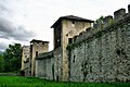
The bastions (also bastions , redoubts or bastions called) were named from west to east: St. Vital bastion (now Kurgarten), St. Virgil bulwark , St. Henry bulwark , St. Rupert bulwark and as a "half bastion" St. Sebastian bulwark . The extension of the former bulwarks can be modeled in the ring-shaped course of Franz-Josef-Straße and Auerspergstraße. The bulwarks had an approximately 6 m high defensive wall ( Niederwall ) on the edge of the defensive ditch , behind which the circular corridor was located 1.5 m below . Behind this 4 m wide corridor, which runs through all the bulwarks, was the 7 m high upper embankment (including the 1 m high parapet on the crown of the wall) . From the top edge of the parapet to the bottom of the weir trench there is a difference in height of a good 12.5 m.
The ground plan of the individual bastions was roughly pentagonal on the same side. The bulwarks (bastions) were connected by walls and behind them the ramparts, the curtains (courtines). The sides of the curtains connected to the base ( throat ) ; the top of the bulwark, called saillant , was formed by the two facets . At the three front corner points of the sides of the bulwark, there were small military observation towers (Auslug, Gaffe), as we know them from Kapuzinerberg or fortress.
The weir ditch itself consisted of a level base area, which had a circumferential 1 m elevated care path near the inner wall . The water ditch, which was usually a good 1 m deep and about 10 m wide, was embedded in the wide weir ditch .
Upstream between the bulwarks were four ravelins , namely the St. Vital Ravelin , the St. Virgil Ravelin , the St. Heinrich Ravelin and the St. Rupert Ravelin . They were also named in turn Ravelin I to Ravelin IV .
Before 1700 there were four horn works in front of the bulwarks , which protruded far to the north and east. In the west they reached about to today's railway line towards Munich . They were called (like the bulwarks) St. Vital Hornwerk , St. Virgil Hornwerk , St. Heinrich Hornwerk and St. Rupert Hornwerk .
The defensive wall from the Lederertor to the Inner Stone Gate
The water bastion left Paris Lodron in 1641 south of the bulwark St. Vital build. The wall to the west of Mirabell Palace led to a bastion that has been used as a theater garden since around 1700. In the area of today's Mozarteum foundation building, there was another bastion facing northwest. The Lederertor also protruded towards the Salzach in order to be able to fight a possible enemy coming from the north. Soon after the construction of the defensive wall between the Lederertor and the main bridge, low military buildings were added, and the wall was hardly noticeable. The space between the main bridge and the inner stone gate was not more secure, here a closed row of town houses extended to the Salzach.
Kapuzinerberg
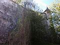
At least in winter, on the Kapuzinerberg, the wall line from the Capuchin monastery to the Franziskischlössl along the south side of the Beg, but also the wall line from the cloister garden to the soldiers' staircase to the north is clearly visible. Prince Archbishop Paris Lodron had it erected on the edge of the plateau as a two-kilometer long winding wall. The wall in the east from the Franziskischlössl to the Oberer Gnigler Kavalier, on the other hand, is only preserved in the smallest remains. Two cavaliers , the large and the small Linzertor cavalier, built into the steep rock in the north, are also part of the defenses on the Stadtberg. The main road leading into the city from the east and the associated defensive structures could be monitored from above. The little cavalier could be reached directly from the Linzertor and the barracks there via a soldiers' staircase carved into the rock . Two other cavaliers are the Lower and the Upper Gnigler Kavalier , which were built around the Gnigler Schanze in the Talenge towards the Neuhauser Schlossberg ( Kühberg ) in order to be able to adequately protect the eastern slope of the Kapuzinerberg.
The bastions above Steingasse and Platzl were particularly well secured : These defensive structures also included the garden of the Capuchin monastery in the fortifications. The Imbergstiege from Steingasse and the Prügelweg from Linzer Gasse were provided with well-fortified arches. The defensive positions of the mountain also include a gun bastion and an originally double defensive wall with a sideline gate (outer defensive wall not preserved) in the east. There were also three powder towers , a horse mill and, next to what used to be soldiers' quarters, three rainwater cisterns and a drinking water cistern (Brunnstube) on the Kapuzinerberg .
Old town on the left
After the Mönchberg with its carved rocks in the west gave the old town on the left a good protection, adequate protection of the old town between the Klausentor in the north and the Kajetanertor and the bulwark St. Erentrudis in the south was only necessary on the salt axis. The entire area to the Salzach was then militarily secured. The essential parts of the defenses up to the main bridge were then: the Klausentor with drawbridge over the weir ditch and Klausenkavalier (today Humboldtterrasse) above the gate, the defensive wall train from the Klausentor to the Sternbastei (also jokingly called the Elba Island ) and then the Old Thürnitz with the Fleischtor (Water gate). From there a short piece of defensive wall led to the main bridge.
Above the main bridge, a train of defensive walls leads along the Salzach to the Antretterhaus. There followed with Imhofstöckl, Hofbinderstöckl and Zeugwartstöckl in the north and the defensive wall in front of the Spaur'schen and the Starhemberg'schen Canonical House in the south, a defense wall around the Michaelstor . Even further upstream followed the extensive St. Erentrudis bulwark with the Kajetanertor.
Mönchsberg and Festungsberg
The old fortifications on the Mönchsberg were also redesigned. The flanks of the mountain were further scarred in order to design them as defensive walls:
The Müllner Schanze was gradually built in the north of the mountain with its three weir levels and the two weir gates as well as its circumferential (now mostly filled in 4.5 m deep and eight meter wide) weir ditch, which with its foreworks directly to Augustinergasse and on Müllner Hauptstrasse is enough. The Müllner Schanze reached to the Klausenkavalier (Humboldtterrasse) in the east and to the Kavalier under the Johannesschlössl in the west.
The defensive wall east of the vigilante group towards the Riedenburg district was raised significantly, the rocks there were scarred and the old stairway to the mountain was closed. The two kennels in the southwest of the mountain (today Richterhöhe ) were reinforced to the west (towards Bucklreuth) by a defensive wall. The Lower Zwinger was strengthened by a new guard house (Weingartenhaus). The gap between Mönchsberg and Festungsberg with its previous access road from the south was closed with a wide defensive wall. The outer and inner Schartentor were built here to protect the fortress frontworks. The cat as the fortress frontwork was significantly reinforced and redesigned.
The medieval castle was designed and expanded to a modern fortress by adding surrounding gun bastions (Upper and Lower Hasengraben Bastion, newly designed Upper and Lower Nonnberg Bastion, gun bastion in the south). In addition, the castle was significantly better secured with defensive walls and barrier arches in the area of the Hohe Weg towards the city. The high Gothic roof of the high floor was replaced by a low ditch roof and thus better protected against gunfire.
The access road from the St. Peter district to the Mönchsberg (today Toscaninihof) was closed with a high wall; instead of the previous road, a secured stairway ( St. Peter Wacht , Mönchsbergpforte) was built.
Further weir systems to secure the city of Salzburg
In the east of the city, the Gnigler Schanze with its high, well-fortified wall and a ditch in front of it, was built between the steep eastern foot of the Kapuzinerberg ("Fürberg") and the Schlossberg with Neuhaus Castle in front of the Kühberg. This hill was also secured by the two Gnigler cavaliers on the Fürberg and from Neuhaus Castle. As a defense structure, it was largely abandoned around 1700. It was leveled above all during the construction of the Giselabahn and subsequently with the construction of the marshalling yard.
When the Leopoldskroner Moos in the south of the city could not be crossed by an army with a baggage train and wagon, only a small area at the foot of the Untersberg remained open for an enemy attack. This area was closed with the Glanegg Castle and a wall at the foot of the Untersberg.
Preserved parts of the fortifications
In the old town on the left, the remains of the wall on Rudolfskai on both sides of the former Michaelstore were not torn down. Remnants of the St. Erentrudis bulwark were also preserved in the south near the Schanzlpark and in the Basteigasse area. The Outer Nonntaler Tor, redesigned by Paris Lodron and later closed, was saved from demolition as a basement room in Schanzlgasse 14. The Gstättentor (1618, first installation around 1280) and the Klausentor (1612) were also largely preserved.

Remnants of the city wall on Rudolfskai

St. Erentrudis bulwark

Gstättentor

Klausentor


,_Salzburg.jpg)
The Müllner Schanze as a three-tier weir system with Augustinerpforte and Monikapforte and the Klausen-Kavalier (Humboldt-Terrasse) as well as the Kavalier under the Johannesschlössl secured the former royal seat to the north. However, the deep weir ditch surrounding the Müllner Schanze is now filled in, and the weir system was also severely affected by a new serpentine road. The carved rocks of the Mönchsberg , some with a defensive wall, served mainly in the area to the east of the vigilante group, in the area to the west of today's Richterhöhe and in the area of today's Toscaninihof also for defense. The gatekeeper house of the lower kennel next to Richterhöhe was also important to secure the sideline gate there. The defenses in the immediate vicinity of the Hohensalzburg Fortress were particularly important. These include the cat (first system from the time of the second city fortifications) and the outer gun bastions of the Hohensalzburg Fortress as well as the preserved part of the defensive walls in the area of the Schanze between Mönchsberg and Festungsberg with the Inner Schartentor as well as the defensive walls and arches in the fortress area.
In the area of the old town on the right-hand side, the inner stone gate , the water bastion in the Mirabell garden and the defensive wall (bastion) that bound the hedge theater to the west and stretching behind the building of the Mozarteum Foundation, were not dragged as otherwise the theater garden in the Mirabell garden would have been severely impaired or destroyed .

Inner stone gate

Water bastion


Most of the defensive walls on the Kapuzinerberg have been preserved. The gun bastion in front of the defensive wall in the east has not been structurally secured for decades and is increasingly deteriorating. The last remaining remains of the defensive wall on the east side of the mountain are also degenerating unsecured. The Kleiner Linzer Kavalier is now used again as a popular viewing terrace (the old soldiers' staircase, however, is currently not accessible). The viewing terrace of the Großer Linzer Kavalier is currently blocked by a fence and is hardly visible. The Upper and Lower Gnigler Cavaliers in the east of the mountain have been preserved. The Obere Gnigler Kavalier is a viewing platform, the Lower Gnigler Kavalier is privately owned and has buildings. Next to Linzer Gasse at the ascent to the mountain is the fortification of the Felixpforte , not far from it is the Hettwer Bastion and surrounding bastions. The Franziskischlössl is also well preserved in a slightly modified form.

Part of the defensive wall on the Kapuzinerberg

Felix Gate
Defensive wall southeast of the Franziskischlössl
.jpg)


In 2018, the defensive walls on Mönchsberg will be renovated by mountain cleaners and employees of a specialist company.
The razing of the fortifications in the 19th century
With the annexation of the state of Salzburg (or most of Salzburg) to the Austrian monarchy at the beginning of 1816, the facilities came into imperial ownership. In 1860 the statutes of the entire city as a fortress were repealed. The fortifications no longer corresponded to the development of weapons. In 1866 the fortifications between Mirabell Palace and the Linzer Tor were given as a gift from the municipality on the occasion of the 50th anniversary of the annexation of Salzburg with the Austrian Empire. The fortifications were then gradually demolished. The material was used for the regulation of the Salzach or (to a lesser extent) for the sewage system.
Historical maps
- Reinhard Medicus created a largely cadastral series of city maps of the city of Salzburg (30-year intervals) for the years 1800–2010
- Austrian city atlas / Salzburg (various details in the city atlas growth map are partly controversial)
- Growth phase map with legend, from the beginnings to 1830 (information there is partly controversial.)
literature
- 900 years of the Hohensalzburg Fortress. State festival 4-12 June 1977 , series of publications by the State Press Office, Salzburg 1977
- Walter Kirchschlager: Salzburger Stadttore , Edition Salis, Verlag Salzburger Druckerei, Salzburg 1985
- Reinhard Medicus:
- The rocks of the Mönchsberg and their history , in: Bastei , magazine of the Salzburg City Association, No. 2004/3
- The Müllner Schanze and the Thirty Years War , ibid. No. 2005/1
- The northern cliffs of Imberg and their history , ibid. No. 2005/4
- The stone and the two gates on the stone , ibid. No. 2006/3
- The fortifications on Imberg , parts I and II, ibid. No. 2008/1 and 2
- The cat and the two gates , ibid. No. 2013/4
Web links
Individual evidence
- ↑ orf.at: Salzburg city wall is being extensively renovated . Article dated August 10, 2018, accessed August 10, 2018.