
Belgian-Prussian boundary stones

The Belgian-Prussian border stones mark in accordance with the decisions of the Congress of Vienna of 1815 the former border between the Kingdom of Belgium , which until 1830 still part of the Kingdom of the United Netherlands was, and the Kingdom of Prussia .
In 1817, oak posts were erected at prominent points along the border line. From 1840 they were replaced with and with stone, in different shapes and materials, and supplemented with smaller intermediate stones until the beginning of the 20th century. They were also numbered consecutively, with the numbers 1 to 75 counting among the boundary stones between the Grand Duchy of Luxembourg and Prussia and starting at Schengen on the French border. From number 75 on the municipal boundary of Gouvy and Burg-Reuland , they mark the border between what was then the Kingdom of the Netherlands, from 1830 Belgium, and Prussia. After Luxembourg broke away from the Netherlands in 1866, stone 75 was the triangle of Belgium, Prussia and Luxembourg. The last stone on this border has the number 193 and is located on the former four-country corner on the Vaalserberg . The Dutch-Prussian boundary stones connect to the north of the Vaalserberg as far as Mook en Middelaar . In addition, massive customs houses, so-called officials' houses, were built in several places on the Prussian side, which also served as official accommodation for the customs officials.
With the Versailles Treaty of 1919 and the associated connection in January 1920 of the former Malmedy and Eupen districts to the state of Belgium, the borderline lost its raison d'etre and the stones were no longer needed and therefore no longer serviced, which is why some fell into disrepair or due to land and forestry measures disappeared. Belgium confiscated the old customs houses and later sold them to private individuals. All boundary stones along the German-speaking Community , including those that no longer exist, were placed under monument protection in 1996, as were the stones with the numbers 155 to 157 in the High Fens in 1991 .
course

The former Belgian-Prussian borderline reached from the triangle Luxembourg-United Netherlands-Prussia (from 1830 Luxembourg-Belgium-Prussia) in the hamlet of Schmiede (Luxembourg) west of Lengeler and north of Huldingen to the triangle United Netherlands- Neutral Moresnet- Prussia (from 1830 Quadrangle Belgium-Neutral-Moresnet-Netherlands-Prussia) on the Vaalserberg. According to the stipulations in the Aachen Border Treaty of 1816, the border ran from boundary stone number 76 along the old road from Luxembourg in the direction of Stavelot to the west past the village of Recht to Pont. In the further course it led along the Rechterbach and the Amel via Francorchamps to Baraque Michel . From there it followed the course of the Hill until shortly before Eupen , made a southwestern detour around Eupen past Baelen and the Garnstock monastery at the level of the Wetzlarbad, to reach Herbesthaler Straße / rue mitoyenne . The big road formed the border to the White House (municipality of Lontzen) and then to Kelmis (then Neutral Moresnet). From there she moved up to the Vaalserberg.
The stones with the numbers 76 to 111 and 158 to 193 mark the western border along today's German-speaking Community and stones 75 and 112 to 157 that of the communities of Malmedy and Weismes , which fell to Prussia in 1815 despite the dominance of the French language. In a few places, mostly at crossroads or on the Weser , a stone was placed on both the Belgian and the Prussian sides, with the actual borderline running between them. This concerns stones 173 and 174 on the Weser, stones 178 to 186 between the communities of Eupen and Baelen and number 187 between Lontzen and Welkenraedt , of which stones 186 and 187 were even three. At the Neutral Moresnet borders, along Grünstraße (now Lütticher Straße) there were two times two pieces with the number 188. The intermediate stones that were subsequently inserted in the Malmedy district were given the number of the last official boundary stone with an additional alphabetical letter.
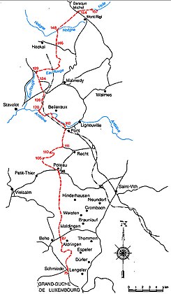
Boundary course and boundary stones in the Malmedy district

Boundary course and boundary stones in the Eupen district


A peculiarity in the Malmedy district was that the course of the border was interpreted differently by the two countries when the first border markings were set up between number 88 and 96. Prussia saw a straight line from stone to stone, the Netherlands (Belgium) saw the course of the trade route. This created a no-man's land between stones 93 and 94 . Neither the Netherlands (later Belgium) nor Prussia were responsible for this. The mistake was only discovered in 1897 when someone wanted to build a house in the area between Hof Kretels and Stein 94. The line was then re-measured in 1898 and the protocol for the actual border line in Stavelot was signed in 1909 . Many intermediate stones were set up, which made the exact course in the area visible. This also clearly defined the border around the farms. During the measurements it was also discovered that stone 94 was completely wrong, namely 30 meters on Prussian territory. However, he was never transferred to the right place.
At the borderline between stones 173 and 174, which forms a section of the border between Eupen and Membach (now Baelen), the Weser has either broken a meander or the breakthrough was created artificially. Therefore stone 174 has been lost, but a new one with the number 173¹ has been erected on the former bed of the Weser. No documents have been found yet, but research has shown that this happened between 1873 and 1914.
The borders of the former area of Neutral-Moresnet and the boundary stones there between the southern tip with stone number 188 and the northern corner with stone 193 on the Vaalserberg play a special role. According to the Emmerich Protocol of September 23, 1818, a border between the Netherlands / Belgium and Neutral-Moresnet was created west of the territory, along which the stones with the numbers 188, 189, 189½, 190, 190½, 191, 191½, 192 and 193 are positioned and to the east a border between Neutral Moresnet and Prussia, along which the stones with the numbers 188, 189, 190, 191, 192 and also 193 are located. Later the entire border from Neutral-Moresnet was marked with 60 wooden piles, which were replaced by square stones. Most of them have been preserved, but have not yet been placed under monument protection. Neutral Moresnet was dissolved in 1920 with the Treaty of Versailles and the territory of Belgium was granted.
Another specialty is the last stone with the number 193 on the Vaalserberg. This was originally on the border of the former quadrangle, in the place of which there is now a new stone without a number for the three remaining countries. The old boundary stone 193 has meanwhile been moved 50 meters further north-north-west, where it marks the highest point in the Netherlands together with the two other stones Netherlands No. 1 in the middle and Belgium No. 1928.
description
The construction of the border markings began in 1817 and initially consisted of oak stakes that were painted black and white on the Prussian side and orange and white on the Dutch side. They were 8 Rhenish feet (2.51 meters) above the ground, were square, and 8 Rhenish inches (21 cm) thick. They were all erected between February and October 1817. However, they proved to be very susceptible to weathering and therefore had to be gradually replaced by stone ones from 1840, including first the piles with the numbers 79, 126, 147 and 149, all of which are octagonal and made of bluestone and about 1.75 meters high are.

Dimensions of the boundary stones in the Malmedy district

Dimensions of the boundary stones in the Eupen district
.jpg)
.jpg)
All other wooden posts were exchanged between 1863 and 1865 and replaced by stones of different dimensions and shapes, with the base usually having a diameter of 40 to 60 cm. In the former Malmedy district (numbers 76 to 157), with the exception of the four hexagonal, square stones that were replaced in 1840, they were 1.70 meters above the ground. In addition to the number, there is also the letter "B" for Belgium on the one hand and a "P" for Prussia on the other. The intermediate stones added in 1909 are square, only 30 cm high and are marked with the number and a letter. In the former district of Eupen (numbers 158 to 193) the stones are only labeled with the numbers and are usually square and about 1.20 meters high or, more rarely, octagonal with a total height of 1.70 meters.
- Landmarks (selection of construction type)
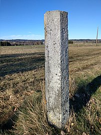
Boundary stone no. 89 near Burg-Reuland; hexagonal, 1.70 meters high

Intermediate boundary stone No. 93 L near St. Vith, square, 30 cm high

Boundary stone No. 187 at Henri Chapelle, octagonal, 1.70 meters high

Border stone no. 173 on the Weser, square, 1.20 meters high
.jpg)
.jpg)

.jpg)
literature
- Gottfried Loup: Limits in history and ethnicity of Eupen. In: Geschichtliches Eupen , Volume 8, Grenzecho Verlag 1974, pp. 51-67.
Web links
- Map of the boundary and existing and lost boundary stones on Historic Place (zoomable and historical maps switchable)
- Belgian-Prussian boundary stones , on the pages of ostbelgienkulturerbe.be
- Belgian-Prussian landmarks by Peter Driven on the pages of grensmarkeringen.be (in Dutch)
- Belgian-Prussian landmarks by Jannis Deeleman on the pages of grenspalen.com (in Dutch)
- Landmark routes , on the website of the Royal History and Museum Association
- Belgian-Prussian boundary stones on Grenzsteine.de
Individual evidence
- ^ Treaty of Aachen 1816 , sur gr-atlas.uni.lu
- ↑ No man's land - a neutral and tax-free zone? , Boundary stone routes, board number 3
- ^ Procès-verbal Général de la ligne de démarcation entre les Royaumes des Pays-Bas et de Prusse, conclu et signé à Emmerich, le 23 Septembre 1818.
- ↑ [1] , on Historic Place