
Bellwald
| Bellwald | |
|---|---|
 |
|
| State : |
|
| Canton : |
|
| District : | Goms |
| BFS no. : | 6052 |
| Postal code : | 3997 |
| Coordinates : | 655064 / 142101 |
| Height : | 1560 m above sea level M. |
| Height range : | 1073-3060 m above sea level M. |
| Area : | 13.96 km² |
| Residents: | 378 (December 31, 2018) |
| Population density : | 27 inhabitants per km² |
| Website: | www.bellwald.ch |
 Bellwald |
|
| Location of the municipality | |
  |
|
Bellwald ( Valais German Beuwaud [ ˈbeuˌɑud ]) is a municipal municipality and a civic municipality in the district of Goms in the Swiss canton of Valais . It also forms a parish of the dean's office in Ernen .
geography

Bellwald is north of Brig high above the Valais Rhone Valley at 1560 m above sea level. M. and is thus the highest municipality in Goms . The village, located on a south-facing slope, has been accessible since 1962 via a winding road or since 1956 by cable car from the Fürgangen- Bellwald train station (since 1915) of the Matterhorn-Gotthard Railway (MGB).
Bellwald has been part of the Swiss Alps Jungfrau-Aletsch UNESCO World Heritage Site since 2007 .
The village of Bellwald grew mainly on the hilltop towards the north-east, where the valley station of the chairlift to Alp Richene or Richinen is located, and has grown loosely here with the district of Ried. On the road downhill to Fieschertal, the districts of Egga and Bodma follow . To the southwest below Bellwald, a little above the Rottens , is the district of Fürgangen with the train station. The eastern settlements of Schlettere and Nessulschliecht are no longer inhabited ; in the latter there is a chapel in addition to some useful buildings. The place Mutti above the village has completely merged with Bellwald as a result of loose redevelopment.
Surname
Various information can be found about the oldest documents for the name of the municipality: 1273 Nicholaus de Bellewalt , Beliwalt , 1293 Belwalt . A document from 1374 (apun Belwalt Zblattun) suggests that the current name initially referred to the hilltop; this later went over to the main settlement and replaced its older name Zblattun .
The origin of the name Bellwald cannot be determined with certainty because of its late appearance. A composition with the German appellative “forest” is assumed, whereby the front link either goes back to Latin bellum , “pretty”, “beautiful”, or to a Germanic personal name Ballo, Pallo as owner information.
history

In the 14th century Bellwald was inhabited by farmers who paid the bishop interest. In 1404 the noble property was bought by Rudolf von Raron in the hands of Johan de Platea in Niederernen. From the years 1371 and 1436 water regulations have been preserved; the oldest known village statutes were drawn up in 1555. According to the old tithe order, Bellwald and Fieschertal formed one of the nine Goms quarters.
population
| Population development | ||||||||
|---|---|---|---|---|---|---|---|---|
| year | 1850 | 1900 | 1950 | 2000 | 2010 | 2012 | 2014 | 2016 |
| Residents | 266 | 285 | 265 | 427 | 460 | 434 | 427 | 395 |
Attractions

Bellwald has a well-preserved, car-free village center with typical, sun-burned Valais wooden houses, stables and narrow streets. On the southern edge of the village is the parish church to the seven joys of Mary , built in 1698, with rich baroque furnishings. Next to it is the mountain cemetery with the ossuary. Many chalets and hotels have been built around the village center since the opening of the street .
The parish church with ossuary stands on the southern edge of the village center of Bellwald. The current church was built from 1698 and consecrated on September 10, 1704. The ossuary was built between 1733 and 1734.
Chapel of St. Apollonia
The chapel is one of the three surviving structures in the Nesselschlucht settlement. The chapel was probably built in 1666, the year in the carved and painted vault medallion in the choir allows this to be concluded. The almost square structure has an edge length of around five meters and is covered by a gable roof. The building axis follows the valley to the northeast and has two arched windows on the valley side. On the western side of the portal there is a walled oculus above the portal. The interior is not divided and is covered by a barrel ceiling, which is divided by a belt strip. A sprouted wooden lattice separates the choir with the altar. During the 18th century the chapel was given to the patronage of St. Apollonia consecrated, the original patronage of the Blessed Mother has been forgotten. In the first half of the century the chapel was still a pilgrimage chapel frequented by pilgrims from far away, mainly because of toothache, but in the second half of the century it fell into disrepair. In 1863 Bishop Joseph de Preux and in 1879 Bishop Adrian Jardinier demanded that the chapel be restored or demolished. Thanks to a testamentary donation from Joseph Wellig from Fiesch, it was possible to restore the chapel in the same year. It received a new shingle roof in 1964.
Maria zum Schnee chapel (Alp Richene)
The chapel is the center of the old Alp Richene and was built in 1694. This year is also carved into the lintel.
Chapel of Our Lady (Ried)
A chapel was built here immediately before 1633, but today's chapel is a new building from 1686. The chapel was built between 1967 and 1970 by Walter Feliser from Brig and Johannes Horestes Bundschuh from Naters under the supervision of the federal preservation authorities renovated. Walter Mutter from Naters was responsible for renovating the ceiling and furnishings.
Chapel of the Coronation (Egga)
The year of origin of the Egga village chapel is unclear, but the architectural style suggests that it was built in the second half of the 17th century. The fact that a picture was founded in 1531 suggests a previous building. The chapel has had some patronage changes, for example it was consecrated to All Saints' Day in 1687, at the latest since 1736 to the holy mother Anna, and since 1863 the patronage has been dedicated to the Coronation of the Virgin.
Chapel of the Coronation of Mary (Upper Bodma)
The chapel dates from the 17th century and was first mentioned in 1687 as a private chapel of the Perren family, built in honor of the Coronation of the Virgin. However, the bell was cast as early as 1653.
Chapel of Saint Anne
This chapel is on the road from Fürgangen to Bodmen, where the old mule track branches off to Bellwald. Because of a donation from 1531 that has become known, it can be assumed that there was a previous building. The construction of today's chapel goes back to a foundation from 1650. The year 1659 can be found in the eaves strip of the nave ceiling . There is a construction seam between the nave walls and the slightly higher choir walls . At the end of the 17th century the chapel was rebuilt (among other things, the floor was raised by about one meter). This is also indicated by the year 1684 with the initials SAZ above the gable oculus.
Holy Trinity Chapel
It is known that the Fürgangen village chapel was already in place in 1687, but was not yet consecrated , which suggests that the building was completed in that year. The patronage of the Holy Trinity is mentioned for the first time in the visitation files of 1736 .
tourism
Many hikers come to this community in summer. The two chairlift sections on Richenen and Steibechriz open up a hiking area with small mountain lakes with good views of the Valais mountains up to the Matterhorn . The highest vantage point is the Risihorn at 2875 m above sea level. M. Von Richenen at 2040 m above sea level. M. leads a mountain bike downhill slope with 400 m difference in altitude to the chairlift valley station. Bellwald is also on the popular Gommer Höhenweg , which leads from Fiesch via Bellwald to Münster in Obergoms. In the village itself there are managed sports and leisure facilities above the village center, including a soccer field, mini golf and tennis facilities, barbecue and children's playground as well as a fun park for skaters. Bellwald has 1200 holiday apartments and 4300 guest beds (as of 2002).
A suspension bridge for pedestrians leads from Bellwald to Fieschertal (Aspi-Titter suspension bridge, 160 m) and to Ernen (Goms Bridge, 278 m).
In winter, skiers and snowboarders in particular use the village for their holidays. The Bellwald ski area with a detachable 4- seater chairlift , a detachable 2-seater chairlift and two ski lifts extends from 1600 m above sea level. M. up to 2550 m above sea level. It has blue, red and black ski slopes and a snowmaking system .
literature
- Philipp Kalbermatter: Bellwald. In: Historical Lexicon of Switzerland . 2004 .
- Walter Ruppen: Bellwald . In: Society for Swiss Art History (Ed.): The Art Monuments of the Canton of Valais Volume 2 Untergoms (= Art Monuments of Switzerland ). tape 67 . Birkhäuser Verlag, Basel 1979, ISBN 3-7643-1080-4 , p. 290-347 .


View from Steibechriz to the Matterhorn and Weisshorn

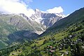
The hillside location on an aerial photo to the east

Church and village center

View from Ernen on the opposite Bellwald (on the hill in the background)

Bellwald village center

Bellwald seen from Eggishorn
View over the district of Ried to the Gross Wannenhorn


Web links
- Bellwald on the ETHorama platform
- Official WebGIS of the Bellwald community
Individual evidence
- ↑ Permanent and non-permanent resident population by year, canton, district, municipality, population type and gender (permanent resident population). In: bfs. admin.ch . Federal Statistical Office (FSO), August 31, 2019, accessed on December 22, 2019 .
- ↑ a b c Dictionnaire toponymique des communes suisses - Lexicon of Swiss community names - Dizionario toponomastico dei comuni svizzeri (DTS | LSG) . Edited by the Center de Dialectologie at the University of Neuchâtel under the direction of Andres Kristol. Verlag Huber, Frauenfeld / Stuttgart / Vienna 2005, ISBN 3-7193-1308-5 ; Éditions Payot, Lausanne 2005, ISBN 2-601-03336-3 , p. 137.
- ^ A b c Philipp Kalbermatter: Bellwald. In: Historisches Lexikon der Schweiz ., Version of February 11, 2005.
- ^ A b Walter Ruppen: The art monuments of the canton of Valais II: Untergoms . (= Swiss art monuments. 67). Birkhäuser, Basel 1979, ISBN 3-7643-1080-4 , pp. 290f.
- ↑ Website Aspi-Titter suspension bridge
- ↑ Bellwald: Goms Bridge
Bellwald | Binn | Appoint | Fiesch | Fieschertal | Goms | Lax | Obergoms
Former parishes: Ausserbinn | Biel | Blitzingen | Geschinen | Gluringen | County | Mühlebach | Munster | Münster-Geschinen | Niederernen | Niederwald | Oberwald | Upper frames | Reckingen | Reckingen-Gluringen | Ritzingen | Selkingen | Stone house | Ulrichen
Canton of Valais | Districts of the canton of Valais | Municipalities of the canton of Valais