
Bergeracois
The Bergeracois is a traditional French landscape in the southwest of the Dordogne department . Its center is the city of Bergerac in the Nouvelle-Aquitaine region . It is roughly the same as the tourist term Périgord pourpre .
geography

The Bergeracois is surrounded by the following landscapes:
- the Landais and the Périgord central in the north
- the Périgord noir in the east
- the Haut-Agenais in the south
- the Entre deux mers in the west.
Other landscape subdivisions in the Bergeracois are:
- the Alverois
- the Lindois
- the Pays de Vélines
The topographically lowest point of the Bergeracois at 5 meters is on the Dordogne in the extreme west, the highest points at 231 meters are at Sainte-Alvère in the northeast and at 273 meters at Soulaures on the southeast border.
administration

The Bergeracois belongs to the Bergerac arrondissement of the Dordogne department with the cantons of Bergerac-1 , Bergerac-2 , Lalinde , Pays de la Force , Pays de Montaigne et Gurson , Sud-Bergeracois and parts of the canton of Périgord Central . Responsible municipal associations are the Communauté de communes des Bastides Dordogne-Périgord , the Communauté de communes des Portes Sud Périgord , the Communauté de communes de Montaigne Montravel et Gurson and the municipal association Communauté d'agglomération Bergeracoise .
Hydrography
The Bergeracois is traversed in its northern half by the Dordogne, which drains to the west . Tributaries of the Dordogne are on the right the Caudeau with its left tributary the Louyre , the Eyraud and the Lidoire and on the left the Couze , the Gardonnette and the Seignal . The tributaries on the right generally drain to the southwest, whereas the tributaries on the left drain to the northwest. Lidoire and Seignal are border rivers to the Gironde department . The Dropt flowing west to the Garonne forms roughly the southern border of the Bergeracois to the Lot-et-Garonne department .
geology
Geologically, the Bergeracois is part of the Aquitaine Basin . It is mainly covered by formations of the Upper Cretaceous , the Tertiary and the Quaternary . The eastern section - separated by a discordance from the overlying Tertiary - is built up by calcareous sediments of the marine Upper Cretaceous. The western section is dominated by Tertiary continental detritus.
After the Atlantic had completely retreated at the end of the Upper Cretaceous, the limestone platform fell victim to severe weathering and karstified . From the Lower Eocene to the Oligocene , large inland deltas and alluvial plains were installed on the dry shelf , which were fed with intensive weathering products such as granitic sands and clays from the Massif Central . From the Obereocene onwards, smaller lakes emerged in the western and southern Bergeracois , in which carbonates alternated with detritic molasses . In the Quaternary, today's river network emerged, with up to nine terraces being laid out in the Dordogne valley. The periglacial weathering modeled the valley slopes in the course of the successive ice ages . The karstification of the Upper Cretaceous continued even under the tertiary continental cover and is likely to be effective to this day.
The Upper Cretaceous includes Campanium (Campanium 3) to Maastrichtian . The Tertiary extends from the Lower Eocene to the Upper Oligocene. After the layer gap of the Miocene , the last feldspar-rich river sands were washed in in the Pliocene . During the Quaternary period, extensive colluvial alterites formed on the plateaus and slopes, which often largely mask the actual strata. Gravel terraces were laid out in the Dordogne valley, the oldest of which, which was formed before the Mindel glacial period , is 90 to 100 meters above the current level of the Dordogne.
history
.JPG)

Somewhat comparable to the Périgord noir, the Bergeracois also has a rich early history . Due to the lack of rock overhangs ( abrises ) and caves, however, the sites are mostly located outdoors. The Bergeracois was of great importance to prehistoric people because of its wealth of high quality flint bulbs ( flint ). This valuable raw material was found scattered up to a distance of 100 kilometers in northern Aquitaine.
The first human traces come in the Bergeracois from the middle Acheuléen . Artifacts from the Moustérien , Périgordien with Aurignacien and Magdalenien follow . The Mesolithic is missing, but the Neolithic is very rich in stone artifacts and the first ceramic remains. In addition, the first real dwellings appear with the associated fireplace.
Numerous gallery graves (Allées Couvertes), dolmens , menhirs , cromlechs and polissoire have been preserved in the Bergeracois from the megalithic period . Examples can be found in the municipalities of Baneuil (Dolmen Tranche du Saumon ), Beaumont-du-Périgord ( Dolmen Peyre Nègre ), Capdrot (menhirs Claud , La Motte , Péchegut and Peyrecourt and Cromlech Le Roc Pointu ), Lanquais , Liorac-sur -Louyre (Dolmen Roc Leva ), Marsalès (Allée Couverte l'Oustal del Loup ), Nojals-et-Clotte (impressive Allée Couverte Peyrelevade ), Saint-Cassien (Allée Couverte La Courrège and Polissoir Les Charrieux ), Saint-Félix-de -Villadeix and Saint-Marcory (Menhir Pierre Grande ).
A burial mound ( tumulus ) near Le Fleix was probably from the Iron Age .
Traces of the Lyon-Bordeaux Roman road can be seen in the municipality of Liorac-sur-Louyre from Roman times . Remains of Roman roof tiles and amphorae have also been found here. The Roman road Agen-Périgueux is also documented, as evidenced by the discovery of a milestone south of Issigeac . In 1994, the remains of Gallo-Roman thermal baths from the 4th century were also uncovered in Issigeac . In Montcaret a Roman was Villa from the 1st or 2nd century discovered. It contained mosaics and a swimming pool . Roman remains came to light in the municipalities of Le Fleix and Port-Sainte-Foy-et-Ponchapt (Gallo-Roman villa of the 1st century).
During the Great Migration , the Visigoths invaded the Bergeracois and destroyed the thermal baths of Issigeac. Later the Merovingians built a necropolis here .
Bastides were founded in the Bergeracois in the 13th century , examples are Beaulieu (1284), Beaumont-du-Périgord (1272), Eymet (1270), Lalinde (1267), Molières (1284), Monestier (1284) and Monpazier (1284) . These are foundations of the English King Edward I , who secured his possessions in Gascony.
In the Hundred Years War (1337-1453) the Bergeracois was fought over strongly between the English and the French.
Since the barons of Biron , Bergerac and Eymet had joined Protestantism in 1561 , the region became very involved in the decades of Huguenot wars (1562–1598). At the end of the 16th century, the Bergeracois had grown into a Protestant stronghold with a predominantly Protestant population. Two temporary peace treaties were negotiated in the Bergeracois - the Peace of Bergerac in 1577 and the Peace of Fleix in 1580.
In the Guyenne there were uprisings of the croquants from 1635 , which also affected the Bergeracois. The decisive battle in which the peasants were finally defeated took place on June 1, 1637 not far from Eymet near La Sauvetat-du-Dropt .
Photo gallery

Old town of Bergerac

Saint-Martin church in Vélines
La Rue Castle Tower in Lalinde

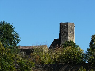
Donjon of Saint-Alvère

The Eymet arcades

Old town of Issigeac
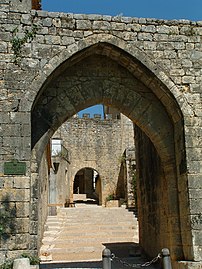
Porte de Lusies in Beaumont-du-Périgord

Saint-Dominique church in Montpazier


.JPG)
_Vieille_maison.jpg)


See also
- Dordogne department
- Périgord
- Landais (landscape)
- Périgord central
- Périgord noir
- Arrondissement of Bergerac
literature
- J.-P. Platel: Bergerac - Sud-Ouest du Périgord . In: Carte géologique de la France at 1/50 000 . BRGM, 1985.
- Frédéric Zégierman: Le Guide des Pays de France, Sud . Fayard, 1999.