
Berkel
| Berkel | ||
 Course of the Berkel |
||
| Data | ||
| Water code | DE : 9284 | |
| location | Germany | |
| River system | Rhine | |
| Drain over | IJssel → IJsselmeer → North Sea | |
| River basin district | IJssel | |
| source | southeast of Billerbeck 51 ° 57 ′ 13 ″ N , 7 ° 18 ′ 39 ″ E |
|
| Source height | 131 m above sea level NN | |
| muzzle | in Zutphen in the IJssel coordinates: 52 ° 7 ′ 58 " N , 6 ° 11 ′ 34" E 52 ° 7 ′ 58 " N , 6 ° 11 ′ 34" E
|
|
| length | 114.6 km | |
| Catchment area | 849 km² | |
| Discharge at the Ammeloe A Eo gauge : 351 km² |
MNQ 1958-1998 MQ 1958-1998 Mq 1958-1998 MHQ 1958-1998 |
620 l / s 3.89 m³ / s 11.1 l / (s km²) 33.4 m³ / s |
| Outflow A Eo : 849 km² at the mouth |
MQ Mq |
9.5 m³ / s 11.2 l / (s km²) |
 |
||
The 114.6 km long river Berkel is a tributary of the IJssel . Its upper and middle reaches are in the Münsterland in Germany , the lower reaches in the Netherlands .
geography
course
The Berkel rises in a saddle of the Baumberge between Nottuln and Billerbeck , around 22 km west of Münster . The Baumberge watershed runs near the source . Other watercourses, whose sources are in the vicinity, flow to the sea in completely different ways.
The Berkel, initially flowing northwest, reaches the outskirts of Billerbeck after a good two kilometers, where it is strengthened by a strong spring at the confluence of a dry valley , which is also known as the Berkel spring . Your valley widens to a wide depression within the tree mountains. At Coesfeld it emerges into the valley sand plains of the western Münsterland Bay and then flows in a westerly direction through the cities of Gescher , Stadtlohn and Vreden , which are around 10 kilometers apart . Behind Vreden the Ölbach flows into the Berkel.
From the source to Vreden, the Berkelaue is designated as a protected area within the meaning of the Habitats Directive ( Natura 2000 -Nr. DE-4008-301) over a length of around 40 km .
The Berkel reaches Dutch territory shortly after Vreden. For a few hundred meters it forms the state border with the Netherlands. The Berkel flows over Eibergen , Borculo , Lochem and Almen on to Zutphen , where it flows into the IJssel after 114.6 km . From Borculo, watercourses branch off from it, which initially feed the Twentekanal before the branched off water reaches the IJssel in another way.
Cities on the river
Germany:
Netherlands:
Historical events and usage
From a military point of view, Berkel gained importance in the Thirty Years' War through the battle of Stadtlohn : in 1623 Christian von Braunschweig and his Protestant army from Göttingen moved towards the Netherlands . He was pursued by Johann Graf von Tilly , a commander of the Catholic League .
On August 6th both armies reached Berkel at Stadtlohn . Since Christian no longer had time for an orderly translation, he was forced to set up his army to fight to enable the entourage to translate. However, after Tilly was able to break through Christian's ranks, chaos broke out as the entourage clogged the bridges and an orderly retreat was no longer possible. So the battle ended in a slaughter in which up to 10,000 soldiers lost their lives and Christian's army was completely wiped out.
.JPG)
The Berkel was navigable from Coesfeld until 1774 in order to transport sandstone from the tree mountains . Due to the mostly low water level, flat bottom ships ( zomps ) were used.
In the German section, the Berkel has a significantly higher gradient than in the Dutch, so that water power can be used here; for example in Coesfeld by the Neue Mühle (grain mill), the Kolver Mühle and Mühle Hautmann, in Gescher by the Mühle Tungerloh and Alfers Mühle , in Stadtlohn by the Stadtmühle and in Vreden by a power station (formerly a water mill).
In the past few years, Berkel has increasingly come into focus as a connecting element. The cooperation between the German Berkel communities culminated in the first Berkel Action Day , which took place on September 11, 2016. In 2017, the day of action took place across borders on 23 July with the participation of the Dutch municipalities. On both sides of the border, a life-size sculpture by Winfried Nimphius with the title The Bathers on the River was set up in all Berkel communities . This means that Berkel has a uniform identity-giving figure from the source to the mouth.
tourism
In 2011 the bike path known as the Berkel route was opened, which leads near the river from Billerbeck to Zutphen. The Berkel route is part of a cross-border cycle route network , which also includes the aa , slinge and ijssel routes . The cycle paths offer six round trips and can be combined with each other.
gallery

Alte Berkelfurt on the upper course in Billerbeck

Egberdings mill near Gescher
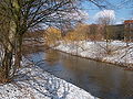
The Berkel near Vreden

Kingfisher in the Berkelaue near Vreden
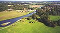
Berkel near Eibergen

The Berkel near Almen

The Berkel in Lochem
.jpg)
.jpg)
.jpg)


Movies
- The Berkel. A film by Anna Schlottbohm and Willem Kootstra , DVD by the LWL-Medienzentrum für Westfalen with booklet, 2017.
literature
- Doris Röckinghausen: Berkel - My life as a river / Mijn leven as a rivier . 1st edition. WortART roeckinghausen, 2016, ISBN 978-3-00-052589-6 .
- Hartmut Levermann: The Berkel: From the character of the Emscher to a valuable biotope for man and nature. "Blickpunkt. Magazine on culture, history and leisure in Westmünsterland." Edition October 2015. Typografische Werkstatt & Verlag Stegemann [Ed.]. Dülmen 2015.
Web links
Individual evidence
- ^ German basic map 1: 5,000
- ^ Topographical Information Management, Cologne District Government, Department GEObasis NRW
- ↑ Water directory of the State Office for Nature, Environment and Consumer Protection NRW 2006 ( Memento from February 15, 2010 in the Internet Archive ) (PDF; 1.03 MB)
- ↑ Water profiles NRW, sub-catchment area Issel ( Memento from March 4, 2016 in the Internet Archive )
- ↑ Ammeloe level data increased by runoff of the remaining catchment area, based on the area runoff for Rekken (364 mm / a; from: P. Warmerdam, M. Mulder, J. Kole: Berkel catchment area, is monitoring network and rainfall runoff relationship ( page no longer retrievable , search in web archives ) Info: The link was automatically marked as defective. Please check the link according to the instructions and then remove this notice. Wageningen 2007)
- ↑ Natura 2000 areas in North Rhine-Westphalia: Berkelaue.
- ↑ Information on the IJsselmeer tributaries ( memento from January 1, 2014 in the Internet Archive ), accessed on 09-05.2012
- ↑ The Berkel Action Day in Stadtlohn: Image 1 of 69 . ( ruhrnachrichten.de [accessed on October 12, 2017]).
- ^ Allgemeine Zeitung Coesfeld , print edition from November 5, 2016, local section Coesfeld
- ↑ See Achterhoek and Westmünsterland rivers .
- ↑ river landscape rivierenlandschap achterhoek · westmünsterland. (PDF; 5.3 MB) Four beautiful bike tours. Retrieved October 2, 2011 .