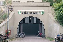
Berlin-Schulzendorf

Schulzendorf is a location in the Berlin district of Heiligensee .
geography
With the Greater Berlin Act , Schulzendorf was incorporated into Reinickendorf on April 27, 1920 . Schulzendorf lies - with the Diakoniezentrum, the "Beyschlagsiedlung" named after the chairman of the Prussian Geological State Institute Franz Beyschlag and the Tegelgrund settlement - between the Beyschlag tunnel and the forest house tunnel of the A 111 in the Tegeler Forest. That is why Schulzendorf is often given the addition 'bei Tegel'.
Development and status
Schulzendorf was founded on July 6, 1772 as Schultzendorff by King Friedrich II (the "Old Fritz"). In a long-term lease it says: "[...] at the tea oven in Heiligenseesche Heyde are to be brought together into a single establishment under the name Schultzendorff." The name comes from the forest councilor Schultze, who in 1708 on the Eichelberg (today: Apolloberg) one Tar stove built. In 1743 an inn and inn was added there.

In 1801 Schulzendorf had 35 inhabitants. In 1822 the colonist Wilhelm Neue (known under the name Neye ) settled here . Some of his descendants still live in Heiligensee. You own u. a. the Gasthaus Sommerlust .
With the opening of Kremmener train in 1893 was near the present highway junction 3 Schulzendorfer road the A111 of Schulzendorf Station . This is served by the S25 line of the Berlin S-Bahn . On the maps in Meyers Konversationslexikon (Vol. 2 - city map to page 752 Berlin, year 1885–1901) Schulzendorf is at the upper edge northwest of the railway underpass (UFTegelgrund) with a building unit on the southern edge of the Chaussee opposite the Apollo-Berg ( 65 m ) recorded.
The Berlin address book from 1922 shows the Schulzendorf colony bounded between Neu-Ruppiner Chaussee and Kremmener Bahn, with the district boundary to Heiligensee crossing Chaussee 570 meters west of the (today's) street Am Tegelgrund. On the Schulzendorfer Flur on the left (southern) side from the Tegel area there is the Revierförsterei (Revierforster F. Herrmann), the forest worker (eight residents), the Neyeschen Gasthof (owner innkeeper Albert Neye), the Fleischmanschen Gasthof "Waldklause" (owner farmer Karl Fleischmann, owner of the inn Jurgis Kairies), way to the settlement, district Heiligensee. The settlement of the building cooperative "Schulzendorf" is noted with seven parcels.
In the address book of 1925 Schulzendorf is included under the Reinickendorf administrative district with four streets:
- Apfelallee : Neu-Ruppiner Chaussee - Beyschlagstraße - Kremmener Bahn: construction sites
- Beyschlagstrasse: Apfelallee - (right side) Breitkopfstrasse - Neu-Ruppiner Chaussee
- Neu-Ruppiner Chaussee: Tegel Forststraße - Apfelallee - Breitkopfstraße - Beyschlagstraße - Heiligensee district
- In the Waldwinkel: Kremmener Railway - Beyschlagstraße - Neu-Ruppiner Chaussee
In addition to construction sites (parceled and partially allocated properties), 16 new buildings, 31 developed properties, the forest workers' house, the Neyesche and the Fleischmannsche Gasthof adjacent to it, as well as the district forestry with the state forest forester F. Hermann bordering on the Tegel district are listed .
Entries in the address book from 1943 for Schulzendorf Post Tegel:
- The Neu-Ruppiner Chaussee is continuously numbered as Ruppiner Chaussee in Schulzendorf (see also Tegel and Heiligensee) with 137–159 (odd, on the right side is Forst).
- The road 1 (previously Apfelallee; since 1978: In Tegel reason) has an underpass under the railway.
- The Dambockstrasse planned in Heiligensee before 1920 is indicated as far as Ruppiner Chaussee. It led from Keilerstraße as Planstraße 7 since 1927 with an underpass under the railway into the local situation as a private road. This connection has been called Erich-Anger-Weg since 1989 and runs through and in the Diakoniezentrum Heiligensee (Diakonieweg). This facility is located on Diakonieweg with 1.5 hectares northeast of the railway line in the local area and a larger area southwest of the railway on Heiligenseer Flur. These areas were undeveloped until 1980.
- At the beginning of the 1940s 50 lots were built on, on Ruppiner Chaussee 143 there is the restaurant "Sommerlust" by innkeeper Neye (Beyschlagstrasse 6) and on 145/147 the restaurant "Waldklause" by innkeeper M. Kröling. Other properties are also designated as so-called construction sites, for example Ruppiner Chaussee 161–167 and Straße 1 . Across from the confluence of Am Waldwinkel, between Beyschlagstraße 13 and 15 (odd, 14 is opposite), a wet meadow (2018: numbers 13a-13j) is also designated as a construction site.
From 1936 to 1937 the anti-aircraft barracks complex was built on Ruppiner Chaussee by the Reich Aviation Ministry . During the occupation of Berlin in April 1945, the Red Army initially took over the barracks and handed them over to the French occupying forces in September 1945 . In 1952 the property came to the Berlin police , who first used it by the riot police and later by other organizational units. Since 1974 the area has also been used by the state fire brigade school.
Web links
Individual evidence
- ↑ a b Schulzendorf location on map of Berlin 1: 5000 (K5 - color edition)
- ↑ File: Meyers b2 s0761a.jpg , File: Environment of Berlin Meyers Konversationslexikon 1892.jpg , File: Environment of Berlin Meyers Konversationslexikon 1894.jpg , File: Berlin 1905 Meyers Konversationslexikon 6th edition.jpg
- ↑ Neye . In: Berliner Adreßbuch , 1922, I., p. 2272.
- ↑ Fleischmann . In: Berliner Adreßbuch , 1922, I., p. 724.
- ↑ Kairies . In: Berliner Adreßbuch , 1922, I., p. 1419.
- ^ Parcel owner: assistant to the magistrate, insurance officer, postman, cartographer, assistant and two councilors.
- ↑ Schulzendorf . In: Berliner Adreßbuch , 1925, IV., P. 2069.
- ↑ Schulzendorf . In: Berliner Adreßbuch , 1943, IV., P. 2555.
- ↑ History of the EFJ at a glance
- ↑ New social living space is being created in Heiligensee . In: Berliner Morgenpost , October 15, 2018
- ↑ From the flak barracks to the police quarters with time table
- ↑ Schulzendorf campus
Coordinates: 52 ° 36 ′ 31 ″ N , 13 ° 15 ′ 35 ″ E