
District water authority
| District water authority | |
|---|---|
 |
|
| Basic data | |
| Country: |
|
| Canton : |
|
| Main town : | Kriegstetten |
| FSO number : | 1106 |
| Area : | 76.67 km² |
| Height range : | 419-596 m above sea level M. |
| Residents: | 51,537 (December 31, 2018) |
| Population density : | 672 inhabitants per km² |
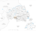
| map | |
 |
|
The Wasseramt district in the canton of Solothurn includes former industrial sites as well as more rural communities and belongs to the Bucheggberg-Wasseramt district .
history
The district was officially called Kriegstetten District for a long time . The area corresponds to 1798 after the invasion of the French revolutionary troops in the Helvetic eliminated Bailiwick Kriegstetten. After 1830 the region was called Amtei Kriegstetten . Until 1875, the democratic successor institutions of the Landvogtei, the Oberamt and the office clerk , were in the main town of Kriegstetten. Then today's office, which also includes the Bucheggberg district, came into being. The district of Kriegstetten was thus only an electoral district. However, the name could not establish itself in common parlance and was officially replaced in 1981 by the previously colloquial, later unofficially used name district water office. This name is derived from the numerous bodies of water in this area.
population
The population density, which is above the cantonal average, resulted from the development of large towns in the plain on the Emme, the strong industrialization since the 19th century and the location of motorway access points in the district. Individual communities (especially Gerlafingen, Biberist, Derendingen and Zuchwil) have an above-average proportion of foreigners.
coat of arms
- divided obliquely left five times by red and silver
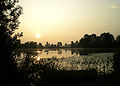
Lakes and rivers
While the Burgäschisee is mostly in the district area, i.e. in the canton of Solothurn, the Inkwilersee is mostly in the Bernese canton area. The Emme flows through the district.

Burgäschisee

Inkwiler- + Burgäschisee
Inkwilersee


Municipalities
Compared to the other districts of the canton , the water authority has the highest number of municipalities with 19. On the other hand, in terms of the number of inhabitants, it ranks second in terms of the number of residents and only fifth in terms of the area of the ten districts.
Zuchwil has the largest number of inhabitants within the district , Biberist covers the largest area and Gerlafingen has the greatest population density. With the lowest values, three points (number of inhabitants, area of the municipality and population density) fall on the municipality of Hüniken . The youngest community is Drei Höfe , which was created in 2013 from a community merger.
Status: 1. January 2013
| coat of arms | Name of the parish | Population (December 31, 2018) |
Area in km² |
Inhabitants per km² |
|---|---|---|---|---|
|
|
Aeschi (SO) | 1214 | 5.48 | 222 |
|
|
Beaverist | 8568 | 12.25 | 699 |
|
|
Bolken | 601 | 2.12 | 283 |
|
|
Deitingen | 2207 | 7.60 | 290 |
|
|
Three yards | 746 | 4.57 | 163 |
|
|
Their endings | 6482 | 5.62 | 1153 |
|
|
Etziken | 881 | 3.37 | 261 |
|
|
Gerlafingen | 5204 | 1.85 | 2813 |
|
|
Hold | 864 | 1.85 | 467 |
|
|
Horriwil | 846 | 2.64 | 320 |
|
|
Hüniken | 148 | 1.02 | 145 |
|
|
Kriegstetten | 1293 | 1.14 | 1134 |
|
|
Lohn-Ammannsegg | 2814 | 4.48 | 628 |
|
|
Luterbach | 3480 | 4.52 | 770 |
|
|
Obergerlafingen | 1176 | 1.51 | 779 |
|
|
Oekingen | 839 | 2.39 | 351 |
|
|
Recherswil | 2009 | 3.36 | 598 |
|
|
Subingen | 3203 | 6.27 | 511 |
|
|
Zuchwil | 8962 | 4.63 | 1936 |
| Total (19) | 51,537 | 76.67 | 672 | |
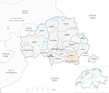
Classification
The district is divided into Inner, Middle and Outer Water Authority. However, this classification is not official, and other people might make it a little different. In principle, the Inner Water Authority is not located in the center of the Water Authority, but near the city of Solothurn . Lohn-Ammannsegg is similar to the municipalities of the middle water authority, but is in a completely different place and is more influenced by the Bucheggberg .
Inner water office : includes the industrialized southern suburbs of Solothurn; these include Biberist, Derendingen, Gerlafingen, Lohn-Ammannsegg, Luterbach and Zuchwil.
Mittleres Wasseramt : The municipalities of Deitingen, Halt, Kriegstetten, Obergerlafingen, Oekingen, Recherswil and Subingen are located in the transition zone between agglomeration and rural areas.
Outer water authority : The communities of Aeschi, Bolken, Etziken, Heinrichswil-Winistorf, Hersiwil, Horriwil, Hüniken and Steinhof are typical rural communities.
Changes in the community
Municipalities until 1938

Municipalities until 1992

Municipalities until 1993

Municipalities until 2011
Municipalities until 2012


- 1939: Change of name from Niedergerlafingen → Gerlafingen
- 1993: Ammannsegg and Lohn → Lohn-Ammannsegg merged
- 1993: Fusion of Heinrichswil and Winistorf → Heinrichswil-Winistorf
- 2013: Merger of Heinrichswil-Winistorf and Hersiwil → Drei Höfe
See also
Individual evidence
- ↑ Permanent and non-permanent resident population by year, canton, district, municipality, population type and gender (permanent resident population). In: bfs. admin.ch . Federal Statistical Office (FSO), August 31, 2019, accessed on December 22, 2019 .
- ^ State Archives: Constitutional revisions in the canton of Solothurn in the 19th century , catalog of an exhibition in the 1980s
- ↑ Federal Statistical Office Generalized Limits 2020.
Web links
- Website for the district water authority
- Free cc photos Wasseramt
- Silvan Freddi: Water Authority. In: Historical Lexicon of Switzerland .