Bliesgau Biosphere Reserve
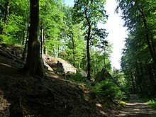
The biosphere reserve Bliesgau is a biosphere reserve of UNESCO in the southeast of Saarland on the border with French region of Lorraine and Rhineland-Palatinate . It covers an area of approx. 36,000 hectares and is mainly characterized by forests , orchards and floodplain landscapes of the Blies . Furthermore, the diversity of animal and plant species as well as the dense juxtaposition of urban and rural areas are characteristic of the region.
geography
location

The Bliesgau biosphere reserve is located in the south-eastern corner of the Saarland and covers an area of 36,152 ha, which corresponds to approx. 14% of the area of the Saarland. In the immediate vicinity of the area are Saarbrücken in the west, Homburg in the north, Zweibrücken in the east and Saargemünd in the south. Most of the areas belonging to the biosphere reserve are in the Saarpfalz district and a smaller part in the Saarbrücken regional association . The towns of Blieskastel and St. Ingbert as well as the communities of Kirkel , Gersheim , Mandelbachtal and Kleinblittersdorf are completely within, the town of Homburg partly in the area of the biosphere reserve.
The area of the biosphere reserve includes most of the landscapes of the Bliesgau (part of the "Saar-Blies-Gau") and parts of the Westrich as well as the natural areas of the Sankt Ingbert-Kirkeler forest area and the St. Ingberter Senke . The highest peaks are the Betzentaler Berg (402 m) south of St. Ingbert, the Hochscheid (401 m) also south of St. Ingbert and the Große Kahlenberg (401 m) between Breitfurt and Böckweiler .
In the southeast, the Bliesgau biosphere reserve borders directly on the cross-border Palatinate Forest / Northern Vosges biosphere reserve .
The Bliesgau, with its rather urban north and a population density that is above the national average (311 inhabitants per km²), is relatively dense for a rural area compared to the other German biosphere reserves. This makes the Bliesgau unique as a biosphere reserve worldwide.
Land use
In the municipalities of Homburg, Kirkel and St. Ingbert, the share of settlement and traffic areas makes up more than 20% of the municipal area, while in the municipalities of Blieskastel, Gersheim and Mandelbachtal it is around 10% each. With 18% settlement and traffic areas, the municipality of Kleinblittersdorf lies in between. In the municipalities of Blieskastel, Gersheim, Kleinblittersdorf and Mandelbachtal around 2/3 of the municipal area is used for agriculture, in Homburg, Kirkel and St. Ingbert this proportion is only around 15-30%. These municipalities in the northern part of the region are significantly more characterized by their high proportion of forest , which is between 43% and 52% here. These differences in the proportions of forest areas between the northern and southern municipalities are primarily due to the natural conditions as well as to cultural landscape care and maintenance measures.
ground
The predominant soil types are limestone soils and brown soils and Parabraunerden , on red sandstone were created. There are also gley soils influenced by the groundwater , e.g. B. in the meadows of the Blies . In some areas, bog soils have formed.
climate
Different general weather conditions are decisive for the climate in Bliesgau . If mild and humid weather prevails in western general weather conditions, in eastern positions it is dry and hot in summer and cold in winter. From the south comes warm to hot weather with varying levels of precipitation and from the north comes relatively cold, sometimes dry, sometimes humid air. The Bliesgau is one of the climatic favored areas of Germany. The annual mean temperature is around 9.5 ° C and is only exceeded by the Upper Rhine Graben and the Freiburg Area . The temperature maximum in July is approx. 18 ° C, the minimum in January is approx. 0.5 ° C. There are two maxima in the annual course of precipitation, one in the period June to August and one in the period November / December. The amount of precipitation is between 800 and 1000 mm, with the greatest amounts of precipitation being found on slopes exposed to the west from larger elevations. The mean annual number of snow days with a height of at least 10 cm is less than five. This makes the area one of the areas with the least snow in Germany. The prevailing wind direction is southwest .
Zoning
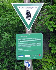
The biosphere reserve is divided, graded according to the influence of human activity, into three zones: In a core , a nursing and a development zone. In the areas of the core zone, an undisturbed forest development with the corresponding biodiversity is sought, an agricultural and forestry use no longer takes place. In the maintenance zones, forms of previous land use are to be exercised and developed, which maintain and develop the valuable and characteristic features of the landscape. In the developing zone to finally on the basis of an active civic a sustained regional development are operated. Core zones are to be protected as nature reserves and maintenance zones predominantly as landscape protection areas.
The core zone consists of 10 sub-areas with a total of approx. 1,109 hectares, which corresponds to around 3.1% of the total area.
The core zone includes the following areas:
- “Moorseiters” (Blieskastel- Altheim , 32 ha), a deciduous forest with over a hundred years old beech / oak stands at the transition from red sandstone to shell limestone.
- "Baumbusch" (Gersheim, 150 ha), a deciduous forest on shell limestone with former quarries , island-like middle stands and a high proportion of cave trees.
- “Böckweiler Wald” (Blieskastel- Breitfurt , 58 ha), Middle Ages hardwood stand on shell limestone with a high proportion of maple and ash .
- "Taubental / In den Drecklöchern" (Kirkel / Blieskastel, 449 ha), a mixed deciduous forest on red sandstone with coniferous wood parts / individual old groups of trees on the high altitudes.
- "Pfänderbachtal" (Homburg, 45 ha), acidic beech forests , in places with old beech trees in a biotope network with a notched brook valley .
- "Kalbenberg Süd" ( Rubenheim / Gersheim, 31 ha), a deciduous forest with a high proportion of ash and island-like middle forest stands, a hybrid of low and high forest.
- "Kleinblittersdorfer Wald" ( Kleinblittersdorf , 51 ha), mixed deciduous forest on shell limestone with over 120-year-old beeches, sessile oaks , mixture with noble deciduous trees .
- " Lindenfels " (Blieskastel- Alschbach , 113 ha), deciduous forest on red sandstone at the transition to the shell limestone with high proportions of coniferous wood and semi-open areas.
- "Former lime mine" (Gersheim / Mandelbachtal , 76 ha), a mixed deciduous forest on shell limestone with high proportions of dead wood on a slope.
- " Oberwürzbach-Hirschental " (St. Ingbert- Oberwürzbach , 98 ha), Middle Ages mixed deciduous forest on red sandstone with individual groups of old trees on a hillside.
The maintenance zone has a size of around 7,033 ha, which corresponds to around 19% of the total area. In the care zone, the aim is to protect the cultural landscapes , i.e. landscapes that have arisen through human use and whose continued existence is to be guaranteed through appropriate human use or care. Against the background of the changed social and, in particular, agricultural policy framework conditions, the aim is to preserve the diversity of species and habitats on the basis of the respective protected area status and to maintain and develop exemplary sustainable forms of land use. The areas that are very valuable from a nature conservation point of view, such as B. the limestone semi -arid lawns , the orchid meadows , species-rich orchards , but also lowland hay meadows and meadow meadows are combined in the care zone. About 30% of the maintenance zone are designated as nature reserves , another 15% as FFH area . Approx. 48% - predominantly forest areas for which natural forest management is to be carried out in accordance with the State Forest Act - are designated as landscape protection areas. The previous use remains permissible in the care zone, which includes a dynamic in terms of variety of uses and usage gradients. Individual regulations are laid down in the maintenance and development plans for the nature conservation and FFH areas. In the care zone, natural forest management remains permitted in accordance with the guidelines of the State Forest Act, as the managed areas - provided they are state- owned or owned by the municipalities of St. Ingbert, Kleinblittersdorf, Blieskastel or Homburg - Forest Stewardship Council (FSC) or Programs for the Endorsement of Forest Certification Schemes (PEFC) are certified.
Flora and vegetation

In the northern, urban areas of the biosphere reserve, in addition to the settlement biotopes , the colline , mesophilic beech forests in the upper red sandstone with marshy bottom valleys dominate . The Southern, rural areas include the biosphere as defining elements semi-dry grasslands , extended lean Flachlandmähwiesen (substantially sage oat grass meadows), orchards complexes , orchids - and Woodruff beech on limestone. 25 of the 50 orchid species native to Germany can be found here.
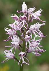
At least eight nationally endangered orchid species , which in many cases have reached their limit of distribution in southwest Germany, occur in several populations, mostly rich in individuals, in the semi-arid grassland of the biosphere reserve. The occurrences of:
- Bald spur ( Aceras anthropophorum )
- Pyramidal Orchis ( Anacamptis pyramidalis )
- Buck's strap tongue ( Himantoglossum hircinum )
- Bumblebee Ragwort ( Ophrys holoserica )
- Monkey orchid ( Orchis simia )
Among the comparable limestone landscapes in Germany, the Bliesgau has a remarkable independence. This is caused on the one hand by the geographical location to the west with connection to the Lorraine limestone regions , on the other hand by the high proportion of marl-containing horizons in the surrounding rock . For example, in the “Saar-Blies-Gau” natural area, heavy soils that tend to waterlogging predominate . This results in a tendency towards alternating moisture, which is noticeable in many types of vegetation.
The region under the Muschelkalk areas also gains independence through the close intermeshing of the semi-arid grassland with the communities of the pipe grass meadows . Here in particular, the transitions take up a lot of space and blue-green sedge ( Carex flacca ) and Purgier flax ( Linum catharticum ) can be found in almost every semi- arid lawn . The lime finial ( Polygala calcarea ), which is considered a subatlantic-southwestern sub-Mediterranean species and which reaches the eastern limit of its closed distribution pattern east of Zweibrücken , is also widespread here. In Germany, the plant can only be found in Baden-Württemberg and Rhineland-Palatinate .
But not only the lime finial is worth mentioning. Other sub-Mediterranean species are characteristic of the area of the biosphere reserve, e.g. B. the large number of species of clover (z. B. Hippocrepis comosa , Anthyllis vulnararia ), flax ( Linum catharticum ), mountain gamander ( Teucrium montanum ), sun rose ( Helianthemum nummularium ) and. a. But also types of the Mediterranean floral element can be observed, e.g. B. Pasque flower ( Pulsatilla vulgaris ), which forms some dense populations in Bliesgau, tender flax ( Linum tenuifolium ), real germander ( Teucrium chamaedrys ).
In Ormesheim can sheeted squill ( Scilla bifolia ) are found in large quantities.
The limestone semi-arid lawns or Trespen semi-arid lawns typical of the Bliesgau are types of vegetation that are predominantly man-made. They were created through grazing or single mowing instead of undemanding forest communities. Depending on the use of two types of Semi-arid Brome grass can be distinguished because the mowing principle makes a selection other than extensive grazing with sheep or goats: the Bromus erectus - and orchid rich dry meadows (Gemähte chalk grasslands) and Festuca - and Brachypodium pinnatum -rich Lean pastures (grazed semi-arid grasslands).
The limestone semi-arid grasslands of the region are of different ages. Those in Bliesgau were created relatively late. Gerhard Hard, who has dealt intensively with the history of the development of the semi-dry limestone grasslands in Bliesgau, determined a time after 1820/1830. According to his research, the Napoleonic plans (1800–1805), the Tranchot map (1818) and the oldest cadastre show that the southern Bliesgau was still completely lacking semi-arid grassland at that time. Rather, the entire country, including today's limestone semi-arid grasslands, was cultivated. Thus, the semi-arid lawns turn out to be quite young. They emerged from permanent farmland that quickly grazed and fell " driesch " (broke). (In the vernacular, the semi-dry lawns are still called "Driescher" today). It was not until the last third, but especially towards the end of the 19th century, that the single-mower or even just used as sheep pasture emerged on the most distant, heaviest and most rocky soils of the district.
The formation of the limestone semi-dry grassland in the Bickenalbtal of the Zweibrücker Westrich z. B. can be backdated to Hard. Around 1800, large parts of the arable land were given up, so that the largest part of today's limestone semi-arid grassland is under this wasteland. Later, from 1845, the barren wasteland, which was even more extensive around 1800, finally began to shrink to its present form and location along the valley.
fauna
The Bliesgau Biosphere Reserve is also of great importance for the biodiversity of the animal world. It is less the nationwide endangered, spectacular species that describe the Bliesgau, but rather the many typical regional representatives that z. Sometimes live on the edge of their distribution area and highlight the Bliesgau as a fauna that loves warmth . It has long been proven that the biotope types that are why the Bliesgau is so important in floristic terms (limestone grasslands with rich orchids) are also important habitat types for fauna. The large group of insects ( grasshoppers , butterflies , cicadas ), birds z. B. Heidelerche ( Lullula arborea ), Rotkopfwürger ( lanius Senator ) Neuntöter ( lanius collurius ) or reptiles that - one might bliesgautypische the lime-lean lawn fauna call - mainly to the lime-lean lawn are adjusted.
Among the mammals, the following are to be emphasized: the beaver (extensive spread after successful reintroduction on the Blies ) and various bat species that z. B. in the Schlossberg caves near Homburg or in the old lime mine in Gersheim have their winter quarters . The more than 40 mammal species in Bliesgau include z. B. also wildcat , hedgehog , mole , fox , badger and dormouse .
Noteworthy among the birds are, in addition to the species typical for their habitat, above all the red kite and the white stork , as well as the little owl as an indicator of the old cultural landscape, which is typical of the orchards. Among the reptiles and amphibians , the yellow-bellied toad , the crested newt , the wall lizard and the smooth snake are special features .
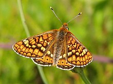
The Bliesgau is the only region in Saarland that is currently home to all of the FFH species of butterflies that have been identified in Saarland ( dark blue butterfly , Quendel ant blue , large fire butterfly , scabiosa piebald butterfly ).
history
The starting point for the designation of so-called biosphere regions was the “Man and biosphere” (MAB) program founded by UNESCO in 1970 - in English: “Man and the Biosphere”. The aim was to protect representative landscapes and to develop them sustainably as model regions. Since the beginning of the 1990s there have been considerations to designate a Bliesgau biosphere region. All the communities in the Bliesgau are committed to this. In May 2001, the Friends of the Biosphere Region Bliesgau e. V. , which was followed in 2006 by the merger of the municipalities of Blieskastel, Mandelbachtal, Gersheim, Kleinblittersdorf, Kirkel, Homburg and St. Ingbert to form the Biosphere Reserve Bliesgau Association . The Saarpfalz district and Saarland are also members of this association. On May 26, 2009, the Bliesgau biosphere reserve was recognized by UNESCO as a German biosphere reserve . Since the end of 2011, the mayor of Kleinblittersdorf, Stephan Strichertz, has been the head of the association, followed by Annelie Faber-Wegener (Blieskastel) from 2006 to 2008 and Herbert Keßler (Mandelbachtal) as head of the association from 2008 to 2011. The managing director is currently (2013) the forestry graduate Walter Kemkes.
Cultural space
The Bliesgau already had a dense network of villas in Roman times - in contrast to the Saargau, which was geologically and geomorphologically similar . The legacies of the Roman settlement, which were wiped out during the time of the Germanic conquest, are u. a. to visit in the Roman Museum Schwarzenacker or in the European culture park Bliesbruck-Reinheim . There were also villa finds near Erfweiler-Ehlingen, Wittersheim or Breitfurt. The Frankish settlement does not follow the Roman one. During this time the -heim and -ingen locations of the Bliesgau were built.
In the Middle Ages there was a differentiated development of settlements in the region. The Wörschweiler and Hornbach monasteries , who set up large courtyards , make a significant contribution to this . Parts of the Sulgerhof in Ormesheim date from the 15th century .
In the early modern period , three-field farming predominated in southern Bliesgau, in the middle and upper Muschelkalk . With the population increase in the 18th and 19th centuries, large parts of the rural population became impoverished, and areas with lower soil fertility were used for agricultural purposes. Even the slopes of the red sandstone were cleared. As a result of the impoverishment, large parts of the population emigrated.
The viticulture in Bliesgau who had a centuries-old tradition that was abandoned in the early 20th century.
Although the Bliesgau seen a conservative agrarian area, a variety of open field and settlements found: Won corridors of different ages, United blocks in Won hallways, group settlements and farmsteads , closed villages and road villages and a differiertes extent of Vergrünlandung. In the course of time, a cultural landscape with impressive diversity has emerged.
literature
- Andreas Stinsky: The Bliesgau. Nature - people - history . Nünnerich-Asmus-Verlag, Mainz 2020, ISBN 978-3-96176-106-7
- Dieter Dorda / Olaf Kühne / Volker Wild (eds.): The Bliesgau. Nature and landscape in the southeastern Saarland . Institute for Regional Studies in Saarland, Saarbrücken 2006, ISBN 978-3-92387-742-3
- Gerhard Hard: Kalktriften between Westrich and Metzer Land . Carl Winter University Press, 1964, p. 176 .
- Hannah Neu: Making nature. An investigation using the example of the Bliesgau biosphere region . Mainz 2008, p. 73 ( iflis.de [PDF] Diploma thesis, Johannes Gutenberg University Mainz, Mainz 2006).
- Biosphärenzweckverband Bliesgau (Hrsg.): Annual review 2007–2008: Biosphärenreservat Bliesgau . Blieskastel 2009, p. 24 p .: Ill .
- Helmut Johannes Wolf: The local forest history of the Bliesgau biosphere reserve as a component of education for sustainable development . Rostock, Univ., Diss. 2010.
Web links
- Literature on the Bliesgau Biosphere Reserve in the Saarland Bibliography
- Biosphärenzweckverband Bliesgau official website
- Friends of the Bliesgau Biosphere Region e. V.
- UNESCO Biosphere Reserve Bliesgau on the UNESCO website
- Information on the Bliesgau Biosphere at: www.blieskastel.de
- Map with the external borders of the Bliesgau biosphere reserve (PDF; 1.5 MB) biosphaere-bliesgau.eu (source: Ministry for the Environment, Energy and Transport)
- Map of the zoning of the Bliesgau Biosphere Reserve On: www.biosphaere-bliesgau.eu (Source: Ministry for the Environment, Energy and Transport)
- ( Page no longer available , search in web archives: map of the zoning concept in the Bliesgau biosphere reserve ) At: iss.umwelt-campus.de/iss/?id=86
Individual evidence
- ↑ a b Profile of the Bliesgau Biosphere Reserve (PDF; 6.3 MB) at: www.biosphaere-bliesgau.eu
- ↑ Betzentaler Berg (402 m) ( Memento from February 13, 2013 in the web archive archive.today ) tourensuche.eu
- ↑ ILEK final report Biosphaere (PDF)
- ↑ Saarland Soil Information System (SAARBIS) at: www.saarland.de
- ↑ Soil overview map of the Saarland. In: State Office for Environment and Occupational Safety of the Saarland - Map service on the Internet. Retrieved May 3, 2020 .
- ↑ Saarbrücken regional studies (online series) on: www.iflis.de (website of the Institute for Regional Studies in Saarland)
- ↑ Hannah Neu: The making of nature. An investigation using the example of the Bliesgau biosphere region . (PDF; 782 kB) Diploma thesis, Johannes Gutenberg University Mainz, Mainz 2006, p. 31/32
- ^ Horst Schneider: Saarland (= collection of geological guides 84). Berlin / Stuttgart 1991.
- ↑ Olaf Kühne: Weather, weather and climate in Saarland (= Saarland booklet 2). Saarbrücken 2004, p. 40 ff.
- ↑ Olaf Kühne: The climate in Bliesgau . ( Memento from July 19, 2006 in the Internet Archive ) derbliesgau.de (undated); Retrieved April 20, 2006
- ↑ a b Hannah Neu: The making of nature. An investigation using the example of the Bliesgau biosphere region . (PDF; 782 kB) Diploma thesis, Johannes Gutenberg University Mainz, Mainz 2006, p. 32
- ↑ Olaf Kühne: Weather, weather and climate in Saarland (= Saarland booklet 2). Saarbrücken 2004, p. 70 ff.
- ↑ a b c d e f g h i Biosphere Bliesgau On: www.blieskastel.de
- ↑ § 10 SNG Biosphere Bliesgau (PDF; 75 kB)
- ↑ a b Core Zones - Primeval Forests of Tomorrow . (PDF; 519 kB) Flyer
- ↑ Map Ordinance Natsg biosphaere-bliesgau.eu
- ↑ a b c d Plants in the Bliesgau Biosphere Reserve On: www.biosphaere-bliesgau.eu
- ^ A b c Gerhard Hard: Kalktriften between Westrich and Metzer Land . C. Winter, University Press, 1964
- ↑ a b c d Animals in the Bliesgau Biosphere Reserve On: www.biosphaere-bliesgau.eu
- ↑ 22 New Sites Join the UNESCO's World Network of Biosphere Reserves. Information page on the 22 new biosphere reserves on the UNESCO website, dated May 26, 2009
Coordinates: 49 ° 14 ′ 15.4 " N , 7 ° 15 ′ 35.3" E


