Blouberg (municipality)
| Blouberg Blouberg Local Municipality |
||
|---|---|---|
 |
||
| Symbols | ||
|
||
|
Motto "Kodumela" Busy ' |
||
| Basic data | ||
| Country | South Africa | |
| province | Limpopo | |
| District | Capricorn | |
| Seat | Senwabarwana | |
| surface | 4541 km² | |
| Residents | 162,629 (October 2011) | |
| density | 36 inhabitants per km² | |
| key | LIM351 | |
| ISO 3166-2 | ZA-LP | |
| Website | www.blouberg.gov.za (English) | |
| politics | ||
| mayor | Maseka Solomon Pheedi | |
Coordinates: 23 ° 8 ′ S , 29 ° 0 ′ E
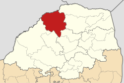
Blouberg ( English Blouberg Local Municipality ) is a local municipality in the Capricorn District , Limpopo Province in South Africa . The administrative headquarters are in Senwabarwana . On August 3, 2016, part of the local community of Aganang was affiliated. The mayor is Maseka Solomon Pheedi.
The Afrikaans-speaking name refers to a mountain range of the same name and also refers to a settlement north of Polokwane on the slopes of the mountains.
places
- Alldays
- Senwabarwana (formerly Bochum )
population
162,629 inhabitants live in an area of 4,541 km² (as of 2011).
Nature reserves
- Blouberg Nature Reserve
Web links
Commons : Blouberg Local Municipality - Collection of images, videos and audio files
- The community site (English)
Individual evidence
- ^ Local Government Handbook. South Africa: Blouberg Local Municipality (LIM351) . at www.municipalities.co.za (English).
- ^ Peter Edmund Raper : Dictionary of Southern African Place Names . Lowry Publishers, Johannesburg 1987 (2nd ed.), Pp. 52-53.
- ↑ 2011 census: Blouberg . accessed on July 14, 2020
