
Bong County
| Bong | ||
|---|---|---|
  |
||
| Symbols | ||
|
||
| Basic data | ||
| Country | Liberia | |
| Capital | Gbarnga | |
| surface | 8772 km² | |
| Residents | 333,481 (2008) | |
| density | 38 inhabitants per km² | |
| founding | 1964 | |
| ISO 3166-2 | LR-BG | |

Coordinates: 7 ° 0 ′ N , 9 ° 40 ′ W
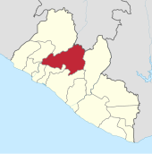
Bong County is an administrative region ( county ) in Liberia , it has a size of 8 772 km² and had 333,481 inhabitants at the last census (2008).
The administrative region was formed in 1964 and is divided into twelve districts. The capital is Gbarnga in the Yeallequelleh district.
| District | Ew. (2008) male |
Ew. (2008) female |
Ew. (2008) total |
|---|---|---|---|
| Boinsen | 4,041 | 4.169 | 8,210 |
| Fuamah | 14,630 | 14,193 | 28,823 |
| Jorquelleh | 38.293 | 40,836 | 79.129 |
| Kokoya | 1,829 | 1,873 | 3,702 |
| Kpaai | 13,044 | 12,905 | 25,949 |
| Panta | 8,137 | 8,336 | 16,473 |
| Salalah | 21,823 | 21,794 | 43,617 |
| Sanoyeah | 15,036 | 15,294 | 30,330 |
| Suakoko | 14,381 | 14,799 | 29,180 |
| Tukpahbllee | 5,737 | 5,994 | 11,731 |
| Yeallequelleh | 17,970 | 18,127 | 36.097 |
| Zota | 9,938 | 10.302 | 20,240 |
| Bong | 164,859 | 168,622 | 333,481 |
Bong County is in the center of the country, the Panta and Zota districts border on Guinea . The population consists mainly of the ethnic groups of the Kpelle and Mandinka .
history
Bong County was formed in 1964, as were Lofa Counties , Nimba Counties, and Grand Gedeh Counties . During the Liberian Civil War , Charles Taylor used the city of Gbarnga as a base in the first half of the 1990s.
economy
Bong County, along with Lofa Counties and Nimba Counties, is one of the most agriculturally productive regions in Liberia. A private company has set up shop and cultivates a total of 1,125 hectares of land, including 400 hectares of lowland rice and 425 hectares of upland rice , vegetables, fish and livestock, providing much-needed employment in the area.
The Bong Range was the concession area of the now extinct Bong Mining Company , it has since been converted into a rice growing area. Part of the open pit has filled with groundwater and is now known as Bomi Lake . The approximately 400 hectares are cultivated by 750 farmers, most of whom are former employees of the mining company. Rice seed production was resumed through a bilateral agreement with Taiwan .
Donations to farming communities for the production of lowland rice, supply of seedlings to replace the aging cocoa and coffee plants, water and sewage, and also food help the region to recover from the effects of the civil war.
The purple in the flag of Bong County symbolizes sunrise, while the orange symbolizes the region's novelty. Two geological instruments represent mining in the region.
politics
In the first Democratic Senate elections after the Civil War, Jewel Howard-Taylor of the NPP and Franklin Obed Siakor were elected as a non-party candidate.
Web links
- County Development Agenda (2008-2012) - current development priorities (PDF, 3.9 MB, English)
Individual evidence
- ^ NPHC 2008 Report Final. (PDF; 676 kB) In: Liberian Institute of Statistics and Geo-Information-Systems (LISGIS). Retrieved October 11, 2010 .
- ^ Liberia, Counties and Districts. (PDF; 0.4 MB) (No longer available online.) In: Liberian Institute of Statistics and Geo-Information-Systems (LISGIS). Formerly in the original ; accessed on October 11, 2010 (English). ( Page no longer available , search in web archives ) Info: The link was automatically marked as defective. Please check the link according to the instructions and then remove this notice.
- ^ Flags of the World
- ↑ en: Wiki, article »Liberian general election, 2005« (the websites linked there for the election are no longer present).
Bomi | Bong | Gbarpolu | Grand Bassa | Grand Cape Mount | Grand Gedeh | Grand Kru | Lofa | Margibi | Maryland | Montserrado | Nimba | River Cess | River Gee | Sinoe