
Bonifacio
|
Bonifacio Bunifaziu |
||
|---|---|---|
.svg)
|
|
|
| region | Corsica | |
| Department | Corse-du-Sud | |
| Arrondissement | Sartène | |
| Canton | Grand Sud | |
| Community association | South Corse | |
| Coordinates | 41 ° 23 ' N , 9 ° 10' E | |
| height | 0-340 m | |
| surface | 138.36 km 2 | |
| Residents | 3,118 (January 1, 2017) | |
| Population density | 23 inhabitants / km 2 | |
| Post Code | 20169 | |
| INSEE code | 2A041 | |
| Website | http://www.bonifacio-mairie.fr/ | |
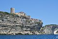
 Port and lower town of Bonifacio in the Calanque de Fazio |
||

Bonifacio ( Corsican : Bunifaziu ) is a port city on the southern tip of the French Mediterranean island of Corsica ( Département Corse-du-Sud ) with 3118 inhabitants (as of January 1, 2017). She gave the Strait of Bonifacio called strait between Corsica and the island a twelve kilometer Sardinia her name.
geography

Bonifacio is the southernmost municipality of the Corse-du-Sud department and the island of Corsica. The place is divided into two areas: the medieval old town called Ville haute (upper town) and the marina in the port area. The Ville haute is located on a 900 meter long, narrow headland made of limestone and sandstone , the Île de Fazio, which runs parallel to the coast, and which on its lake side slopes down to the sea from an average height of 70 meters. On the land side of the headland, a fjord-like bay (French Calanque ) is cut into the limestone, which forms a well-protected natural harbor . There the limestone plateau falls less steeply towards the water. The natural harbor doubles as a fishing and yacht harbor . Furthermore, Bonifacio is a center of merchant shipping and ferry traffic with the neighboring island of Sardinia as well as tourism , especially in the summer months.
history


The official foundation of Bonifacio goes back to the year 828 and the Tuscan Count Bonifacio II . Archaeological finds, however, show that the area was settled in prehistoric times. In 1187, the Genoese managed to take the city with a trick. With one interruption between 1553 and 1559 ( Sampiero Corso ), Bonifacio remained in Genoa's hands until 1768. Bonifacio has been under French rule since 1768. In 1793 Napoleon prepared the failed invasion of Sardinia here. During the Second World War, Bonifacio was occupied by German and Italian troops like all of Corsica in 1942.
Population development
| year | 1962 | 1968 | 1975 | 1982 | 1990 | 1999 | 2007 | 2016 |
| Residents | 2418 | 2431 | 2693 | 2736 | 2683 | 2658 | 2852 | 3048 |
| Sources: Cassini and INSEE | ||||||||
Attractions
The old town of Bonifacio, located on a peninsula-like rock plateau, is probably one of the most impressive in the Mediterranean. The plateau is heavily washed out at its foot on the lake side , so that the houses stand on it almost like on a balcony.
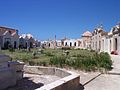
The old town, whose narrow, cobblestone streets are lined with four to five-story houses, can be reached via a drawbridge and a zigzag tunnel to the citadel. The panorama that is offered from the numerous vantage points makes it clear why Bonifacio has always been approached as a haven from the unpredictable weather and current conditions in the Strait of Bonifacio. There is also the view of the built-up with houses white limestone and sandstone rock freely on which gnaws the sea for thousands of years without interruption, then that caves were formed, which are a popular destination. To the west of the old town is the old sea cemetery ( Cimetière marin de Saint-François ), which has almost the character of a small town of its own with countless mausoleums and family tombs .
The city's unique location has repeatedly made it the center of armed conflicts, which is why it was expanded into a fortress over time .
The caves are the destination of boat trips organized from the port, during which the cliffs can also be admired from the sea. From there you can also see the so-called King of Aragon's stairs , the steps of which are carved into the stone and lead from the upper town to the sea.
A hike along the cliffs from Bonifacio in a south-east direction to the southernmost point of Corsica, Capo Pertusato . From there you have a beautiful view of the city.
The restaurants in the port specialize in the preparation of freshly caught fish.

The white rocks of Bonifacio
The cliffs of Bonifacio with the stairs of the King of Aragon

The Grotte du Sdragonato (Dragon's Cave) not far from Bonifacio

The citadel of Bonifacio

Citadel seen from the port
Sea cemetery


Recreational boating
The harbor basin, which is well protected in all weathers, is located at the end of the narrow "Calanque" and therefore does not offer sailing yachts any opportunity to cruise. The entrance itself is difficult to make out, the houses of the old town on the plateau in the east are easy to see.
The white, square tower with the residential building of the lighthouse on Cap Pertusato , which can be seen from the south and west, is clearly recognizable . Coming from the north, the white lighthouse with black gallery on Cap de Feno is the best landmark. On the cliffs below the old town you can see the restored watchtower and stairs carved into the rock ( stairs of the King of Aragon ).
Distances to other ports
| From Bonifacio - to | Nautical miles |
|---|---|
| Propriano | 31 |
| Ajaccio | 43 |
| Calvi | 88 |
| Porto-Vecchio | 25th |
| Macinaggio | 107 |
| Solenzara | 37 |
| Campoloro | 68 |
| Bastia | 91 |
Web links
- Official website of the city (French)
- Office Municipal du Tourisme de Bonifacio - official tourist information (with information in German)
- Area information about Bonifacio on SkipperGuide.de
Individual evidence
- ↑ Timo Lutz: Cimetière Marin de Bonifacio. korsika.fr (tourist website of Michael Müller Verlag ), accessed on August 3, 2018.