Borremosis
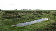
The Borremose is an extensive Danish high moor in western Himmerland , in northern Jutland . The moor is about five kilometers southeast of the city of Aars in the municipality of Vesthimmerland . It extends three kilometers from the southwest to the northeast and is up to one kilometer wide. It is known for its significant archaeological finds. Rævemose (Fuchsmoor), which adjoins Borremose to the north behind a narrow threshold, is where the Gundestrup Kettle was found , a key find from the Iron Age . A moor of the same name lies on Falster .
Archaeological evidence
The fortified settlement

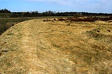
In the south of the moor, the Borremose fortress ( Borremosefæstningen in Danish ) was excavated in the 1930s and 1940s . Until 100 BC Was in use. It is the largest known facility in Jutland from this period. The fortified settlement was built on a small island surrounded by swamps and moors. The island, oriented in north-south direction, was about 150 m long and 80 to 100 m wide. Their enclosure consisted of two trenches and a wall. There was a ditch between the island and the land to the southeast, where the moor is narrowest. A regular road dam was found here, at the same time as the village. The other trench was dug on the outside of the island. It is a ditch with a flat bottom. It differs from later ramparts , which have a pointed moat. It was sunk 1.50 to 2.50 m into the gravel outside of the island and the excavated earth was piled up as a wall on the inside. Since the width of the trench was 4 to 6 m, a considerable amount of gravel was available for the wall. The distance between the crest of the rampart and the outside of the trench was 6 to 8 m and the difference in height between the crest of the rampart and the bottom of the trench was about 1.5 to 2.5 m. The wall was not reinforced with palisades.
The bog corpses that were sacrificed in the earlier Iron Age refer to a cult . During the excavation of the moat, which was filled with rubbish, peat and slipped gravel in alternating layers over time, it could be seen that the facility had only been used for short periods of time in the early days of its existence. Shards of vessels and other things lay scattered on the floor, and for long stretches almost nothing was found. The soil layer had clearly been deposited during the temporary stays. Further up in the ditch was a culture layer with thousands of vessel fragments dating from the 1st century BC. Come from BC.
A defensive function can be excluded for some early earthworks, which consist of successively formed individual overlapping long pits. This type of construction, however, exists in addition to the continuous trench, so that the existence of earthworks without defensive character can be considered secure.
The benchmark
A testimony to the surveying work that preceded the earthworks in Borremose is a 1.35 m long measuring stick made of oak, which closes with a button at one end and is pointed at the other. It is divided into eight units 16.5 cm long by alternately carved convex and concave arches on one side.
The bog bodies
Between 1946 and 1948 , peat cutters found three bog corpses (called Borremose I , II and III ) and some surviving items of clothing in the central area . In contrast to previous finds, they were immediately and professionally examined.
literature
- Peter Vilhelm Glob : The sleepers in the moor. Winkler, Munich 1966
- Peter Vilhelm Glob: prehistoric monuments of Denmark. Wachholtz, Neumünster 1967, p. 257.
- Jes Martens: Refuge - fortified settlement - central place? Three years of archaeological investigations at the Borremose stronghold (1989–1991), an enclosed settlement from the Pre-Roman Iron Age of Himmerland . In: Ethnographisch-Archäologische Zeitschrift 35, No. 1–3, 1994, pp. 241–276.
- Karsten Kjer Michaelsen: Politics bog om Danmarks oldtid . Copenhagen 2002 ISBN 87-567-6458-8 , p. 73.
Web links
Coordinates: 56 ° 47 ′ 30 ″ N , 9 ° 34 ′ 30 ″ E

