
Borsberg (mountain)
| Borsberg | ||
|---|---|---|
 Surveying column from 1865 on the Borsberg |
||
| height | 361 m | |
| location | Saxony ( Germany ) | |
| Mountains | West Lusatian hills and mountains ( Schönfelder Hochland ) | |
| Coordinates | 51 ° 0 '46 " N , 13 ° 54' 12" E | |
|
||
| rock | granite | |

The Borsberg (361 m) is a mountain near Borsberg , a district of Dresden, in Saxony . The mountain is one of the most famous excursion destinations in the Dresden area.
Location and surroundings
The Borsberg is located in the urban area of Dresden in the village of Schönfeld-Weißig . The Graupa district of Pirna is located directly at the foot of the mountain, while the small village of the same name extends to the summit area on the plateau spreading to the north ( Schönfelder Hochland ). Hiking trails connect the Borsberg with Pillnitz Castle and the Meixmühle in Friedrichsgrund .
At the summit there is a historical surveying column from 1865 made of sandstone, the ruins of the Hermitage from the 18th century and the former mountain inn.
Natural space
In terms of nature, the Borsberg can already be assigned to the West Lusatian hills and mountains . The position of the mountain marks the steep drop of the Schönfeld highlands or the Lusatian fault towards the Elbe valley . The Borsberg is thus part of the Wachwitz-Pillnitzer Elbe valley slopes, which stretch from the White Deer to the Doberberg near Wünschendorf .
The Borsberg itself is made of two-mica granodiorite . The starting material for this rock was sandy deposits that were solidified into greywacke around 600 million years ago and later transformed under pressure and high temperatures via intermediate forms. The bluish-gray two-mica granodiorite stands on the southern slope of the Borsberg, in which the sloping valley of the Tiefen Grund has cut deep and narrow, in the form of cliffs or detached boulders.
The southern slopes of the Borsberg towards the Elbe valley have been under nature protection since 1961 and are part of the nature reserve D104 " Dresden Elbe valley slopes " and FFH area 33E "Elbe valley slopes between Loschwitz and Bonnewitz". In particular, the near-natural forest stands are protected (especially sessile oak-beech forests, oak-hornbeam forests, maple-Schatthang forests) as well as various species of bat , breeding bird fauna , amphibian and reptile species as well as ground beetles and butterfly species.
The Graupaer Bach rises on the eastern slopes of the Borsberg , which first flows south-east and, at Graupa, turns to the west of the Elbe, into which it flows in Pillnitz . Before that, it takes up the Tiefen Grund stream between Kleingraupa and Oberpoyritz . The Friedrichsgrund on the western side of the mountain is drained by the Friedrichsgrundbach , which reaches the Elbe in the Pillnitz Castle Park .
history

Elector Friedrich August III. von Sachsen , who later became King Friedrich August I, had a footpath laid out around 1780 through the Friedrichsgrund over the Meixmühle to the Borsberg. To this day, an artificial rock grotto has been preserved on the summit, which houses an octagonal room. The grotto was laid out in 1775 by Count Marcolini for the Elector as a " Hermitage ". It was initially furnished with billet furniture , later with Empire furniture and a fireplace and mirror. From its roof, the visitor was offered an impressive 360 ° view of the Elbe landscape. In the middle of the 19th century, a wooden observation tower was built on the Hermitage to counteract the tree growth that was obstructing the view. The building was maintained by the Saxon court building authority until 1897.
In October 1865, a 5.90 m high, stone surveying point for the Central European degree measurement was built on the mountain. As station No. 7, this served the Royal Saxon Triangulation , which was carried out under the direction of Christian August Nagel from 1862 to 1890. The stone obelisk still preserved today bears the inscription Station Porsberg of the Central European Degree Measurement 1865 .
On the occasion of the 100th anniversary of the death of Christian August Nagel in 2003, the column was restored and a memorial plaque was attached.
The wooden observation tower on the Hermitage was demolished in 2011. Since then, the entire plateau has been closed due to the risk of collapse.
Views
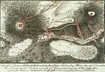
Map around 1850 with the Borsberg

Sketch of the surveying column from 1865

Hermitage ruins on the summit

Historical plaque on the surveying column


See also
literature
- Dresdner Heide, Pillnitz, Radeberger Land (= values of our homeland . Volume 27). 1st edition. Akademie Verlag, Berlin 1976.
- Stefanie Melzer: At 6 o'clock in the morning, his electoral highness went to the Hermitage ... To design Friedrichsgrund and Borsberg slopes in the style of the early sentimental landscape garden . In: Yearbook of State Palaces, Castles and Gardens of Saxony 2006, ISBN 978-3-937602-97-4 , pp. 173-184.
- Christian Preiß: Old streets and paths in the eastern Borsberg area. in: Petra Binder (ed.): On streets, rails and paths. Country calendar book 2011 for Saxon Switzerland and the Eastern Ore Mountains. Schütze-Engler-Weber-Verlag, Dresden 2010, ISBN 978-3-936203-14-1 , pp. 19-24.
Web links
- The Borsberg near Pillnitz on Borsbergstrasse.de
- The Borsberg ( Memento from April 30, 2009 in the web archive archive.today )
- Article Borsberg in Stadtwiki Dresden
Individual evidence
- ↑ Mapping of the natural areas of Saxony (accessed on December 28, 2015)
- ↑ SMUL (ed.): Nature reserves in Saxony. Dresden 2008, p. 368f.
- ^ Hans-Günther Hartmann: Pillnitz - Castle, Park and Village. Hermann Böhlaus successor, 1996, ISBN 978-3-74000-995-3 , pp. 136-137
- ↑ Stefanie Melzer: At 6 a.m. they went ... , Sandstein Verlag Dresden, 2006, ISBN 978-3-937602-97-4 , p. 174.