
Bring
|
Bring
Wedemark municipality
|
|
|---|---|
 |
|
| Height : | 62 m above sea level NHN |
| Area : | 19.22 km² |
| Residents : | 2243 (December 31, 2015) |
| Population density : | 117 inhabitants / km² |
| Incorporation : | March 1, 1974 |
| Postal code : | 30900 |
| Area code : | 05130 |
 Location of Brelingen in Wedemark
|
|
 Brelingen seen from the south with the Brelinger Mountains behind
|
|
Brelingen ( Brelje in Low German ) is a district of the municipality of Wedemark in Lower Saxony in the Hanover region . It also includes the hamlets of Ohlenbostel and Schadehop .
geography
Due to its central location, Brelingen is a connection point between the places Mellendorf , Bissendorf , Elze , Bennemühlen , Ibsingen and Negenborn . The Brelinger Berg is a popular hiking and recreational area.
history
The place was first mentioned in a document in 990. The first church was built around 1200 and ownership of the place changed from the Hildesheim monastery to Minden . In 1483 the church was demolished and rebuilt. A third demolition and a new church took place in 1849. The inauguration of a new school with two classes and a teacher's apartment took place in 1916. This was enlarged in 1962 by an extension.
Brelingen is an old farming village. Towards the end of the 17th century there were 21 courtyards with Meier status , which were created by dividing the earlier (seven) full courtyards , as well as 23 Kötner and Brinkitzer places . Sources of income for the inhabitants were agriculture, livestock and handicrafts.
In 1972 Brelingen, Hellendorf and Gailhof were amalgamated to form the Mellendorf municipality . On March 1, 1974, Brelingen was incorporated into the new municipality of Wedemark.
politics
Local council
The local council of Brelingen (with Ohlenbostel and Schadehop ) consists of two councilors and five councilors.
(Status: local election September 11, 2016)
Local mayor
The local mayor is Patrick Cordes (WGW), he is represented by Hans-Georg Euskirchen (CDU).
coat of arms
The draft emblem of Brelingen comes from the in Isernhagen born and later in Hannover living heraldry and crest painter peoples Gustav , who is also the emblem of Großburgwedel , Melle village , Wunstorf has designed and many other towns. The approval of the coat of arms was granted by the district president in Lüneburg on June 26, 1959.
|
|
Blazon : "In green above a lying, silver wolf's tang , covered by a golden bronze sword , whichis hungon the pommel on a silver cord with a golden scale ." |
| Justification for the coat of arms: The scales are intended to hold the memory of the fact that the official scales of the former Bissendorf District Bailiff were set up in Brelingen until 1858 . A well-preserved bronze dagger with a wooden scabbard was found years ago in the Brelinger Berg district . The Wolfsangel symbolizes belonging to the former Burgdorf district . |
religion
The Evangelical Lutheran St. Martini parish, which has existed since the 16th century, was connected to the parish of St. George's parish in Mellendorf in Wedemark on January 1, 2011, and since then has held one of the three pastors' positions of the communal pastoral office.
Culture and sights
_IIMG_3545.jpg)
- In the center of the village is the Protestant St. Martini Church , which is also the tallest building. It is a hall church built in 1849, designed by consistorial builder Hellner from Hanover.
- The memorial for the fallen soldiers of the First World War is located near the church .
- Not far from there is a boulder that commemorates the victims of the Second World War .
- The historic parish bakery is located on the church grounds.
- The listed old cemetery in Brelingen was laid out in 1846. His chapel, which stood at today's entrance, was demolished in 1964. The last burials took place at this time.
- The Sculpture Path Moving Stones is a 5.5 km long circular path on the east side of the Brelinger Mountains. The path is also a geological adventure trail and the eleven sculptures provide information about the Ice Age and related phenomena.
- The following legend has grown up about the origins of the Brelinger Mountains: a long time ago two giants fought there. They threw rocks at each other until one of them fell and was buried under the stones. The Brelinger Mountains emerged from this barrow. It is also said that two giants wanted to visit each other. One of them made his way to the Deister and when he strolled through the sandy Wedemark, his boot was soon full of sand. He stopped to empty his boot. And when he tipped the sand out of his boot, a hill remained in the Brelinger forest, the Brelinger Berg. A sculpture of the Brelingen giant stands on the northern edge of the village with a suitcase in the field and looks down on Brelingen.
- Motorsport: In the 1980s, motorcycle grass track races took place on the Wedemark-Ring in Brelingen.
- Local specialties are the popular local drink "Brelinger Löschwasser", "Brelinger Korn" and Brelinger Bratwurst.

Old graveyard

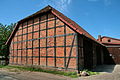
Half-timbered house from 1797
Half-timbered house from 1846
_IMG_7649.jpg)
_in_Brelingen_IMG_7660.jpg)

Architectural monuments
→ See: List of architectural monuments in Brelingen
Economy and Infrastructure
In Brelingen there is a primary school and a kindergarten , day-care center, crèche and a doctor's office. There is a supermarket, a beverage market and a restaurant.
Since 2004 the village has been running the village community center “Brelinger Mitte” under its own administration. Numerous events take place every year in the former inn.
The local associations are organized in the village community. More than 200 activities are published annually in the village calendar.
literature
- Cultural-historical working group Brelingen / Oegenbostel: Bredanlagu, Aingaburstalde: 1000 years of history of the villages of Brelingen and Oegenbostel. 1990
- The 1000 year old Brelingen: home book of a village in the forecourt of the heather Martin Müller, self-published by Brelinger Gemeinschaft, 1977
Web links
- Brelingen on the website of the municipality of Wedemark
Individual evidence
- ↑ Area information for the municipality of Wedemark. (PDF; 10 kB) In: Website of the municipality of Wedemark. January 1, 2011, accessed May 6, 2019 .
- ↑ a b Information with Ohlenbostel and Schadehop.
- ↑ Population of the community Wedemark. (PDF; 121 kB; p. 2) In: Website of the municipality of Wedemark. December 31, 2015, accessed May 6, 2019 .
- ^ Federal Statistical Office (ed.): Historical municipality directory for the Federal Republic of Germany. Name, border and key number changes in municipalities, counties and administrative districts from May 27, 1970 to December 31, 1982 . W. Kohlhammer, Stuttgart / Mainz 1983, ISBN 3-17-003263-1 , p. 221 .
- ↑ a b Local council of Brelingen. In: Website of the municipality of Wedemark - locality Brelingen. Retrieved July 20, 2017.
- ^ A b Landkreis Hannover (ed.): Wappenbuch Landkreis Hannover . Self-published, Hanover 1985, p. 482-483 .
- ↑ Ecclesiastical gazette of the Evangelical Lutheran Church of Hanover 1/2011, p. 65.
- ↑ Brelinger Center | Brelinger middle. Retrieved January 26, 2017 .
Abbensen | Bennemühlen | Berkhof (with Plumhof and Sprockhof ) | Bissendorf | Bissendorf-Wietze (with Wennebostel-Wietze ) | Brelingen (with Ohlenbostel and Schadehop ) | Duden-Rodenbostel | Elze | Gailhof | Hellendorf | Meitze | Mellendorf | Negenborn | Oegenbostel (with Bestebostel and Ibsingen ) | Resse | Scherenbostel (with Schlage-Ickhorst and Wiechendorf ) | Wennebostel