
Breukelen
 flag |
 coat of arms |
| province |
|
| local community |
|
|
Area - land - water |
6.4 km 2 5.88 km 2 0.52 km 2 |
| Residents | 10,845 (Jan. 1, 2017) |
| Coordinates | 52 ° 10 ′ N , 5 ° 0 ′ E |
| Important traffic route |
|
| prefix | 0346 |
| Postcodes | 3621 |
The former Dutch municipality of Breukelen ( ) in the province of Utrecht consisted of the districts Breukelen, Kockengen and Nieuwer Ter Aa . It had a size of 48.7 square kilometers. At the end of 2010 the community had 14,736 inhabitants. Since January 1, 2011, Breukelen has been part of the newly formed Stichtse Vecht municipality .
The city is named after the New York borough of Brooklyn .
location
Breukelen is located on the Amsterdam – Utrecht railway line about 9 kilometers northwest of Utrecht, on the Utrechtsche Vecht and the busiest canal in Europe, the Amsterdam-Rijn Canal . There is some industry and tourism (boat trips on the Vecht).
education
In the medieval castle of the same name is the privatized Nyenrode University of Economics , where business and management training is given. The diplomas are u. a. recognized in the USA (International Business School). The students stay in the castle itself. The former Prime Minister of the Netherlands Wim Kok studied here. The patron was Prince Bernhard, who died in 2004 .
Sons and daughters of the place
- Petrus Johannes Kasteleijn (1746–1794), writer
- PN van Eyck (1887–1954), writer
- Henk van der Grift (* 1935), speed skater
- Pieter Oussoren (* 1943), pastor
- Rutger Hauer (1944–2019), actor
- Evelien de Bruijn (* 1974), TV presenter RTV Utrecht / SBS6
photos
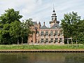
Breukelen, Nijenrode Castle / University

Breukelen, drawbridge over the Utrechtse Vecht
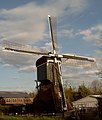
Breukelen, mill


See also
Web links
Individual evidence
- ↑ Kerncijfers wijken en buurten 2017 Centraal Bureau voor de Statistiek , accessed on April 2, 2018 (Dutch)
- ^ Website of the University of Nijenrode