
Cabo da Roca
Coordinates: 38 ° 46 ′ 51.4 ″ N , 9 ° 30 ′ 2.9 ″ W.

Cabo da Roca is the westernmost point of the mainland of the European continent . It is located in Portugal on the Atlantic coast west of Lisbon at an altitude of 140 meters above sea level . Cabo da Roca belongs to the municipality ( freguesia ) Colares in the district ( concelho or município ) Sintra . There is a bus to Cabo da Roca from Sintra and Cascais .

There is a tourist office there, where you can have your visit confirmed on an artistically designed certificate for a fee. Otherwise there is a lighthouse , a bar and a marine radio transmitter .


The slopes are invasively overgrown with the edible ice plant ( Carpobrotus edulis ). This is shown there as a "dangerous intruder". Rare peregrine falcons ( Falco peregrinus ) and kestrels ( Falco tinnunculus ) nest in the rock faces .
The Portuguese national poet Luís de Camões described the place with the following words: Here ... where the earth ends and the sea begins ... (Aqui ... onde a terra se acaba eo mar começa).
The most westerly point of the European continent is the Azores island of Ilhéu do Monchique with a longitude of 31/16/30 / W, apart from Greenland .

View from the cape in north direction

lighthouse

Stone billboard of the city of Sintra

Lighthouse with surrounding buildings at Cabo da Roca (2003)
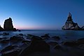
Sea panorama after sunset

cross


See also
Cabo de São Vicente - the most south-westerly point of continental Europe
Web links
- Cabo da Roca , Portuguese, on cm-sintra.pt