California State Route 9

|
|
|---|---|
| map | |

|
|
| Basic data | |
| Overall length: | 61,955 km (38,497 miles ) |
| Starting point: |
|
| End point: |
|
| Counties: |
Santa Cruz Santa Clara |
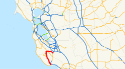
The California State Route 9 (shortly CA 9 ) is about 62 km long State Route in US -Bundesstaat California , the North-South direction runs in. It connects the city of Los Gatos in Santa Clara County in the north with the coastal city of Santa Cruz in Santa Cruz County on the Pacific in the south.
course
CA 9 begins in Santa Clara County near the city of Los Gatos, southwest of the city of San José on California State Route 17 . From here it runs northwest to California State Route 35 and then swings south through the Santa Cruz Mountains at Castle Rock State Park . From here the road runs east of the Big Basin Redwoods State Park along the San Lorenzo River south to southeast. The CA 236 joins the street twice . After nearly 38 miles, California State Route 9 ends in the coastal city of Santa Cruz on California State Route 1 .
See also
Web links
Individual evidence
- ^ California Department of Transportation : State Truck Route List . Retrieved March 13, 2019
