Calumpit
| Municipality of Calumpit | ||
| Location of Calumpit in the Bulacan Province | ||
|---|---|---|

|
||
| Basic data | ||
| Region : | Central Luzon | |
| Province : | Bulacan | |
| Barangays : | 29 | |
| District: | 1. District of Bulacan | |
| PSGC : | 031407000 | |
| Income class : | 1st income bracket | |
| Households : | 16,167 May 1, 2000 census
|
|
| Population : | 108,757 August 1, 2015 census
|
|
| Coordinates : | 14 ° 55 ' N , 120 ° 46' E | |
| Geographical location in the Philippines | ||
|
|
||
Calumpit is a municipality in the Philippines' Bulacan province . In 2015 it had 108,757 inhabitants. To the west, Calumpit borders the Pampanga Province .
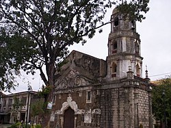
The oldest church in Bulacan is also located in the municipality. The St. John the Baptist Church was built 1,572th The Augustinian Diego Vivar-Ordonez supervised the construction of the church. Inside the church there is a tunnel which, according to legend, was used by priests during the Spanish regime to hide gold, statues and jewelry from the treasure robbers. In 1899 Calumpit was briefly the seat of the government of the first Philippine republic .
Barangays
Calumpit is divided into the following 29 barangays :
|
|
|

