Carabau
| Carabau | ||

|
||
| Data | ||
| surface | 9.81 km² | |
| population | 2,136 (2015) | |
| Chefe de Suco | Manuel B. Noronha (election 2016) |
|
| Aldeias | Population (2015) | |
| Atumnaro | 299 | |
| Carabau | 354 | |
| Nunubuti | 244 | |
| Tasibalu | 195 | |
| Udu-Ai | 1,044 | |
|
|
||
Carabau is an East Timorese village and Suco in the Bobonaro Administrative Office ( Bobonaro municipality ).
The place
Carabau is located in the north of the Sucos at an altitude of 1451 m above sea level. There is a primary school in the village, the Escola Primaria Carabau .
The Suco
| Carabau | ||
| places | position | height |
| Agoltama | 9 ° 3 ′ S , 125 ° 22 ′ E | 723 m |
| Biatuma | 9 ° 3 ′ S , 125 ° 23 ′ E | ? |
| Carabau | 9 ° 1 ′ S , 125 ° 23 ′ E | 1451 m |
| Udu-Ai | 9 ° 1 ′ S , 125 ° 22 ′ E | 1146 m |
2136 inhabitants (2015) live in the Suco, of which 1027 are men and 1109 women. The population density is 217.7 inhabitants / km². There are 358 households in the Suco. Over 95% of the population name Kemak as their mother tongue. Small minorities speak Tetum Prasa , Tetum Terik or Bunak .
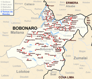
Before the 2015 regional reform, Carabau had an area of 14.99 km². Now it is 9.81 km². The Suco is located in the northeast of the Bobonaro administrative office. In the southwest of Carabau lies the Suco Lour , in the west lie Bobonaro and Lourba and in the north Tebabui and Cota Bo'ot . To the east is the administrative office Zumalai with its sucos Ucecai and Zulo belonging to the municipality of Cova Lima . The river Loumea rises in the north of the Sucos and finally flows into the Timor Sea in the south . A bridge leads over it, with which the country road towards Zumalai crosses the river.
The place Carabau is in the north of the Sucos on the country road towards Gleno . At Udu-Ai ( Uduai ), coming from the north, it meets the country road leading to the west to Maliana and the country road leading to the south to Zumalai. On the latter, on the border with Zulo, is the place Biatuma and somewhat the village Agoltama . In addition to the elementary school in Carabau, there are others in Udu-Ai and Biatuma. In Biatuma there is also a helipad for emergencies.
The five aldeias Atumnaro , Carabau , Nunubuti , Tasibalu and Udu-Ai are located in the Suco .
politics
In the elections of 2004/2005 was Abel Noronha dos Santos elected Chefe de Suco and in 2009 re-elected. In the elections in 2016 won Manuel B. Noronha .
Web links
- Results of the 2010 census for the Suco Carabau ( tetum ; PDF; 8.5 MB)
- Results of the 2015 census for the Suco Carabau (tetum; PDF)
- Seeds of Life: Suco information sheets Bobonaro (tetum)
Individual evidence
- ↑ a b c d Direcção-Geral de Estatística : Results of the 2015 census , accessed on November 23, 2016.
- ↑ a b UNMIT: Timor-Leste District Atlas version 02, August 2008 ( Memento from November 8, 2012 in the Internet Archive ) (PDF; 535 kB)
- ↑ Fallingrain.com: Directory of Cities, Towns, and Regions in East Timor
- ↑ Results of the 2010 census for the Suco Carabau ( tetum ; PDF; 8.5 MB)
- ↑ Direcção Nacional de Estatística: Population Distribution by Administrative Areas Volume 2 English ( Memento from January 5, 2017 in the Internet Archive ) (Census 2010; PDF; 22.6 MB)
- ^ Timor-Leste GIS-Portal ( Memento from June 30, 2007 in the Internet Archive )
- ↑ Jornal da Républica with the Diploma Ministerial n. 199/09 ( Memento of February 3, 2010 in the Internet Archive ) (Portuguese; PDF; 323 kB)
- ↑ Secretariado Técnico de Administração Eleitoral STAE: Eleições para Liderança Comunitária 2004/2005 - Resultados ( Memento of August 4, 2010 in the Internet Archive )
- ↑ Secretariado Técnico de Administração Eleitoral STAE: Eleições para Liderança Comunitária 2009 - Resultados ( Memento of August 4, 2010 in the Internet Archive )
- ↑ Jornal da República: Lista Naran Xefe Suku Eleito 2016 , December 2, 2016 , accessed on June 17, 2020.
