Castelo Branco
| Castelo Branco | ||||||
|---|---|---|---|---|---|---|
|
||||||
| Basic data | ||||||
| Region : | Centro | |||||
| Sub-region : | Viseu Dão-Lafoes | |||||
| District : | Castelo Branco | |||||
| Concelho : | Castelo Branco | |||||
| Coordinates : | 39 ° 49 ′ N , 7 ° 30 ′ W | |||||
| Residents: | 35,242 (as of June 30, 2011) | |||||
| Surface: | 170.26 km² (as of January 1, 2010) | |||||
| Population density : | 207 inhabitants per km² | |||||
| politics | ||||||
| Address of the municipal administration: | Junta de Freguesia de Castelo Branco Largo do Espírito Santo, 41.42 6000-105 - Castelo Branco |
|||||
| Website: | www.jf-castelobranco.pt | |||||
| Castelo Branco district | ||||||
|
||||||
| Residents: | 56,109 (as of June 30, 2011) | |||||
| Surface: | 1 438.18 km² (as of January 1, 2010) | |||||
| Population density : | 39 inhabitants per km² | |||||
| Number of municipalities : | 19th | |||||
| administration | ||||||
| Administration address: | Câmara Municipal de Castelo Branco Praça do Município 6000-458 Castelo Branco |
|||||
| President of the Câmara Municipal: | Joaquim Morão Lopes Dias ( PS ) | |||||
| Website: | www.cm-castelobranco.pt | |||||
Castelo Branco ( port. For White Fort , IPA [ kɐʃ'tɛlu 'bɾɐku ]) is a city in Portugal . It is the capital of the Castelo Branco district , belongs to the Região Centro region and the Beira Interior Sul sub-region . It has 35,242 inhabitants (as of June 30, 2011).
history
The fortress, presumably built by the ancient Romans, was conquered by Portugal in the course of the Reconquista in 1165 and left to the Knights Templar in 1182 , who built a castle here (completed in 1230). The place received its first town charter ( Foral ) in 1213. In the course of the 13th century the place developed and grew beyond the city walls. King D. Afonso IV therefore had the city walls extended in 1343. A significant Jewish community also lived here.
King Manuel I renewed the town charter in 1510. In 1535 Castelo Branco was elevated to a vila (small town) for the first time .
The place was raised to a city ( Cidade ) in 1771 . It then became a bishopric before the diocese was dissolved again in 1881. In 1956 the now co- cathedral São Miguel Arcanjo became the second bishopric.
Since 1959 the place has been the seat of the district of the same name. In 2011 the Rede de Judiarias was founded, an association of places with historically significant Jewish communities, including Castelo Branco.
administration
The circle
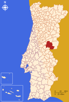
Castelo Branco is the center of one of the largest districts in Portugal, which covers 1438 km². 56,109 inhabitants (as of June 30, 2011) live in 19 communities in the district . Neighboring districts are Fundão in the north, Idanha-a-Nova in the south, Vila Velha de Ródão in the southeast and Proença-a-Nova and Oleiros in the west. Castelo Branco also borders Spain in the south .
With the regional reform in September 2013, several municipalities were merged into new municipalities, so that the number of municipalities decreased from 25 to 19.
The municipalities of the Castelo Branco County are as follows:
| local community | Population (2011) |
Area km² |
Density of population / km² |
LAU code |
|---|---|---|---|---|
| Alcains | 5,022 | 36.94 | 136 | 050201 |
| Almaceda | 677 | 72.19 | 9 | 050202 |
| Benquerenças | 720 | 61.03 | 12 | 050203 |
| Castelo Branco | 35,242 | 170.26 | 207 | 050205 |
| Cebolais de Cima e Retaxo | 1,869 | 25.13 | 74 | 050226 |
| Escalos de Baixo e Mata | 1,216 | 70.08 | 17th | 050227 |
| Escalos de Cima e Lousa | 1,559 | 51.24 | 30th | 050228 |
| Freixial e Juncal do Campo | 823 | 40.67 | 20th | 050229 |
| Lardosa | 961 | 44.47 | 22nd | 050211 |
| Louriçal do Campo | 636 | 22.31 | 29 | 050212 |
| Malpica do Tejo | 517 | 246.02 | 2 | 050214 |
| Monforte da Beira | 378 | 120.35 | 3 | 050216 |
| Ninho do Açor e Sobral do Campo | 746 | 42.97 | 17th | 050230 |
| Póvoa de Rio de Moinhos e Cafede | 926 | 41.07 | 23 | 050231 |
| Salgueiro do Campo | 891 | 30.34 | 29 | 050220 |
| Santo André das Tojeiras | 747 | 74.87 | 10 | 050221 |
| Sao Vicente da Beira | 1,259 | 100.00 | 13 | 050222 |
| Sarzedas | 1,335 | 172.05 | 8th | 050223 |
| Tinalhas | 585 | 16.19 | 36 | 050225 |
| Castelo Branco district | 56.109 | 1,438.18 | 39 | 0502 |
Population development
| Population in Castelo Branco County (1801–2011) | |||||||||
|---|---|---|---|---|---|---|---|---|---|
| 1801 | 1849 | 1900 | 1930 | 1960 | 1981 | 1991 | 2001 | 2011 | |
| 11,536 | 19.093 | 38,302 | 50,434 | 63.091 | 54,908 | 54,310 | 55,708 | 56.109 | |
Town twinning
-
 Brazil : Umuarama
-
 Spain : Cáceres
-
 People's Republic of China : Zhuhai
-
 Brazil : Petrolina
-
 Spain : Plasencia
-
 Angola : Huambo
traffic
Castelo Branco is on the A23 motorway and is a stop on the Linha da Beira Baixa railway line . The place is integrated into the national bus network of Rede Expressos .
The urban area is covered by six bus routes, plus various regional bus connections to surrounding cities and communities.
sons and daughters of the town
- Afonso de Paiva (1443–1490), explorer and diplomat
- João Roiz de Castel-Branco , († 1515), poet of the Renaissance
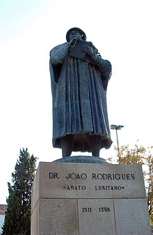
- Amatus Lusitanus (1511–1568), Jewish-Portuguese doctor
- Manuel Dias (1574–1659), Jesuit missionary and astronomer
- João da Mota e Silva (1685–1747), cardinal and politician
- José Ramos Preto (1871–1949), lawyer and politician, briefly Prime Minister 1920
- Maria Olguim (1898–1984), actress
- Eugénia Lima (* 1926), accordion musician
- António Baltasar Marcelino (1930–2013), Bishop of Aveiro
- António Salvado (* 1936), writer and poet
- Ângela Ribeiro (born 1940), actress
- Vasco Lourenço (* 1942), member of the revolutionary Movimento das Forças Armadas
- Marçal Grilo (* 1942), politician, Minister of Education (1995–1999)
- Carlos Correia (* 1947), writer, playwright, pedagogue and communication scientist
- José Manuel Castanheira (* 1952), theater director
- João Filipe Fazendas Vaz , sports journalist also known in Spain for his analysis and knowledge of lusophonic football.
- Nuno Melo (1960–2015), actor
- Joaquim Nicolau (born 1964), actor
- Nuno Filipe Sousa Rolão Dias Santos (* 1976), football player
- Ana Hormigo (* 1981), Judoka
- Sónia Tavares (* 1986), track and field athlete
- Francisco Belo (* 1991), shot putter and discus thrower
Web links
- Map of the Freguesia Castelo Branco at the Instituto Geográfico do Exército
- Description of the city on portugal-live.net , accessed on May 4, 2010
Individual evidence
- ↑ www.ine.pt - indicator resident population by place of residence and sex; Decennial in the database of the Instituto Nacional de Estatística
- ↑ a b Overview of code assignments from Freguesias on epp.eurostat.ec.europa.eu
- ↑ www.ine.pt - indicator resident population by place of residence and sex; Decennial in the database of the Instituto Nacional de Estatística
- ↑ www.verportugal.net , accessed January 26, 2013
- ↑ www.redejudiariasportugal.com , accessed January 26, 2013
- ^ Publication of the administrative reorganization in the Diário da República gazette of January 28, 2013, accessed on March 16, 2014
- ↑ www.anmp.pt , accessed on January 26, 2013


