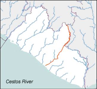
Cestos River
|
Cestos Noun |
||
|
The Cestos in red |
||
| Data | ||
| location |
|
|
| River system | Cestos | |
| source | Near the triangle of Liberia, Guinea and Ivory Coast, on Mount Mont Nimba 7 ° 35 ′ 31 ″ N , 8 ° 25 ′ 1 ″ W |
|
| Source height | 890 m | |
| muzzle | At Cestos City in the Atlantic Ocean Coordinates: 5 ° 26 '46 " N , 9 ° 35' 2" W 5 ° 26 '46 " N , 9 ° 35' 2" W. |
|
| Mouth height | 0 m | |
| Height difference | 890 m | |
| Bottom slope | 1.9 ‰ | |
| length | 476 km | |
| Catchment area | 12,709 km² | |
| Discharge at the Iti gauge (08CE001) = A Eo : 11,585 km² Location: 138 km above the mouth |
NNQ (03/08/2016) MNQ 2015–2019 MQ 2015–2019 Mq 2015–2019 MHQ 2015–2019 HHQ (09/30/2016) |
7 m³ / s 35 m³ / s 313 m³ / s 27 l / (s km²) 880 m³ / s 1704 m³ / s |
| Left tributaries | Boan, Vi | |
| Right tributaries | Kawadi (Kavadi) Creek, Zina Creek, Gan, Gboye Creek, Gwen Creek , Wane, Thu | |
| Residents in the catchment area | 711.346 | |
The Cestos (especially Noun in the upper reaches ) is a river in Liberia and a border river to the Ivory Coast .
course
The river has its source in Ivory Coast at the triangle with Liberia and Guinea, south of the Mont Nimba mountain . It flows in a south-westerly direction and forms the border between Ivory Coast and Liberia for almost half of its route. It flows into the Atlantic at Cestos City .
Hydrometry
Average monthly flow through the Cestos measured at the hydrological station at Iti in m³ / s.

