
Chott el Gharsa
| Chott el Gharsa | ||
|---|---|---|

|
||
| The Chott el Gharsa | ||
| Geographical location | Tunisia | |
| Data | ||
| Coordinates | 34 ° 7 ' N , 7 ° 52' E | |
|
||
| length | 50 km | |
| width | 20 km | |
|
particularities |
||

The Chott el Gharsa ( Arabic شط الغرسة, DMG Šaṭṭ al-Ġarsa ), also Schott el Rharsa, is a sedimentary basin with a salt lake in the southwest of Tunisia , more precisely in the Tozeur governorate . The Schott , a salt flat , lies in a depression and has its deepest point in the northern area at 17 meters below sea level .
Geography and geology
The Chott is about 50 kilometers long and the basin reaches its maximum width with about 20 kilometers in the eastern section. Parts of the chott have their own names. They are Chott Chtihatt Sghatt , Chott Mejez Sfa and Chott Er Rahim . In its south it borders on the semi-arid landscape of Bled el Djerid . In the north there are high mountain ranges of a regional anticlinory made up of sedimentary rocks from the Cretaceous and Eocene periods . These mountains belong to the Djebel En Negueb , a southeastern extension of the Aurès and part of the Atlas Mountains.
By tectonic processes at the time of the Tertiary emerged in southern Tunisia faults , flexures and anticlines . Subsequent erosion and ground movements between existing layer combs ( Northern Gebirgssaum , eastern foothills of Djebel Chareb ) on a basin-shaped depression with sediments is filled. These layered ridges, designed as elongated mountain ranges, form the northern and southern borders of the Chott el Gharsa. Alluvial sands appear in its southern area, and this is where the Sahara plateau with its oasis and other desert landscape connects .
In its extensive geological context, the Chott belongs to a west-east trending depression in the southernmost part of the Atlas system . The well-known Chott el Djerid in Tunisia and the Chott Melghir in Algeria also belong to this sunken zone .
The main freshwater inflow is the Oued El Melah in the west, which brings together the water from the northern mountain range from the region between the cities of Métlaoui and Gafsa . In the area of its peripheral zones, the Chott el Gharsa absorbs fresh water through aquifers . In addition, as in the Chott el Djerid , fresh water outlets occur here, the so-called Aioun (singular: Ain ). These are fresh water outlets under the existing salt crust, which receive their water inflow from the somewhat deeper layers of sand .
The deposits in the depression consist of sands and evaporites ("evaporation rocks"). As a result, there are finely laminated deposits of gypsum that have been deposited since the Pleistocene period. These sediment sequences were compared using analogies with the evaporites on the surface of Mars.

Fata Morgana in the Chott
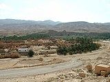
Dilapidated old town of Tamerza , in the background the anticline elevations of the northern mountain range


Agriculture and transport
In sloping terrain north of Chotts, a Bergfußgelände the chains between Tamerza and Gafsa exists agricultural use in the type of limited extent in dryland farming (dry farming). The T16 road runs through this region from the city of Tamerza over the eastern edge of the Chott into the Djerid region to the oasis settlements of El Hamma and Tozeur in the southeast. This guarantees a traffic development. The latter city has a regional airport ( Tozeur-Nefta Airport ) and a railway connection that ends here and leads north.
literature
- Horst Mensching : Tunisia . (Scientific regional customers, Volume 1), Scientific Book Society, Darmstadt 1974
- Michelin road map 743 National. Algeria, Tunisia . 1: 1,000,000. ISBN 2-06-100279-X
Web links
Individual evidence
- ↑ Christopher Swezey, Nicholas Lancaster, G. Kocurek, M. Deynoux, M. Blum, D. Price, J.-C. Pion: Response of aeolian systems to Holocene climatic and hydrologic changes on the northern margin of the Sahara: a high-resolution record from the Chott Rharsa basin, Tunisia . In: The Holocene, Vol. 9 (1999), Issue 2, pp. 141-148
- ↑ N. Stivaletta, R. Barbieri, M. Bosco, GG Ori, L. Marinangeli: Microbial Communities from Continental Sabkhas of Southern Tunisia: Terrestrial Analogues of Mars Evaporite Environments . In: Lunar and Planetary Science XXXVII (2006) (PDF; 228 kB)