Ciudad Bolívar
| Ciudad Bolívar | ||
|---|---|---|
|
Coordinates: 8 ° 7 ′ N , 63 ° 33 ′ W Ciudad Bolívar on the map of Venezuela
|
||
| Basic data | ||
| Country | Venezuela | |
| State | Bolívar | |
| City foundation | 1764 | |
| Residents | 342,280 (2011) | |
| City insignia | ||
| Detailed data | ||
| height | 43 m | |
| Waters | Orinoco | |
| Post Code | 8001 | |
| prefix | 0285 | |
| Time zone | UTC -4: 30 | |
| City Presidency | Lenin Figueroa | |
| Website | ||
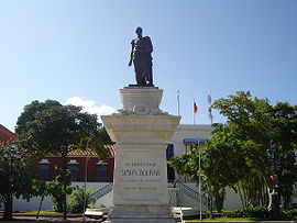
| Plaza Bolivar in Ciudad Bolívar | ||
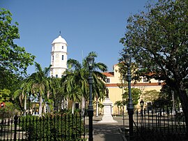
| Orinoco Bridge (Puente Angostura) in Ciudad Bolívar | ||
| Ciudad Bolívar | ||
Ciudad Bolívar is the capital of the state of Bolívar in Venezuela with a population of 342,280 (as of 2011).
The city was founded as Angostura in 1764 and renamed Ciudad Bolivar in 1846 in honor of the freedom fighter Simón Bolívar . Angostura was a contraction of the full name of Santo Tomé de Guayana de Angostura del Orinoco , which means Saint Thomas of Guyana at the narrowing of the Orinoco .
The city lies on a narrowing of the Orinoco that is only 700 meters wide . In 1967, the Puente de Angostura , the first bridge over the river, was opened not far from the city . Ciudad Bolivar's historic center is in a very good state of preservation, with colonial buildings and a cathedral on Plaza Bolivar. Your port on the Orinoco is important for the eastern regions of Venezuela. As one of the main economic centers in the Orinoco basin, its main products are gold, iron ore, cattle, animal skin and rare woods.
The city gave its name to the Angostura tree ( Cusparia febrifuga ) that grows in the region. The bark of the bush-like tree has traditionally been used as a bitter tonic and antipyretic. It is also used in Angosturabitter copycat products .
In 1973 a modern art museum opened, planned by Carlos Raúl Villanueva and named after the city's most famous son, the sculptor Jesús Rafael Soto .
history
Ciudad Bolivar was originally founded as Santo Tomé de Guayana by Antonio Berrío around 1595 at a different location than today. The city endured changes throughout its history until in 1764 the city moved to the narrowest point of the Orinoco and assumed the name Santo Tomé de Guayana de la Angostura del Orinoco . This move was supported by the Spanish Crown, which financed the construction of the church and government buildings.
In 1800 the city was visited by Alexander von Humboldt , who considered it a quiet city bordered by a mighty river and one of the richest places considering Venezuela's natural resources. The narrowing of the Orinoco at Ciudad Bolivar increased its strategic importance and made Ciudad Bolivar one of the key points in the struggle for independence. Because of its geographical position, it was a very difficult place to conquer during the War of Independence. After many battles, Simón Bolívar and Manuel Piar succeeded in 1817 in defeating the Spanish troops, the city - which had recently declared itself independent from the Spanish crown - to conquer and annex the province of Guiana to the Republic of Venezuela, with Angostura declared the provisional capital of the independent Venezuela. The following day Piar was beheaded.
British legionaries also met here with the armed forces of Bolivar before the Battle of Boyacá in the Andes, which secured Colombia's independence. In 1819 Simón Bolívar officially declared the independence of Greater Colombia from Spain in the Angostura Congress . To commemorate the hero of the Wars of Liberation, the city was renamed Ciudad Bolívar in 1846 .
Today it is the capital of the state of Bolívar , which makes up over a quarter of the area of Venezuela.
The population was around 10,000 around 1820 and 312,691 in 2000.
geography
Ciudad Bolivar is located on the southern bank of the Orinoco, on a narrow part of the river, 43 meters above sea level. The northern limit is the Orinoco, while the western, eastern and southern limits represent communities.
economy
Ciudad Bolívar is a region dominated by agriculture and small-scale animal husbandry. Corn, yucca, mango, sweet potato and watermelon are characteristic products that are cultivated in the region. River fishing is practiced on a small scale, and tourism, which supports the region's secondary sector to a large extent, is of great economic importance. Other economic activities located in the city are commerce, services, transport, fast food chains and suppliers to national and international industries.
Culture
Ciudad Bolivar's historic old town is a major tourist attraction, characterized by colonial houses and public buildings.
The Jesús Soto Museum of Modern Art , named after the sculptor and painter Jesús Rafael Soto, shows a collection of modern works by Venezuelan and international artists.
Ciudad Bolívar is the birthplace of musicians such as Cheo Hurtado , Ivan Pérez Rossi and Antonio Lauro . It is also the seat of groups such as Serenata Guayanésa and the Orinoco Ensemble. The following styles of music dominate:
- Venezuelan waltz
- Gallery
- Aguinaldo
- Merengue
- Joropo guayanés
sons and daughters of the town
- Guillermo Castillo Bustamante (1910–1974), composer and pianist
- Luz Machado (1916-1999), author
- Antonio Lauro (1917–1986), composer and guitarist
- Jesús Rafael Soto (1923–2005), painter, sculptor and kinetic artist
- Alfonso Montes (* 1955), composer and guitarist
- Jeffrén Suárez (* 1988), football player
climate
Ciudad Bolívar is located in the tropics of South America. The average annual temperature is 27.5 degrees Celsius and the average annual rainfall is 1029 millimeters. There is a weather station in Ciudad Bolívar itself.
| Ciudad Bolívar | ||||||||||||||||||||||||||||||||||||||||||||||||
|---|---|---|---|---|---|---|---|---|---|---|---|---|---|---|---|---|---|---|---|---|---|---|---|---|---|---|---|---|---|---|---|---|---|---|---|---|---|---|---|---|---|---|---|---|---|---|---|---|
| Climate diagram | ||||||||||||||||||||||||||||||||||||||||||||||||
| ||||||||||||||||||||||||||||||||||||||||||||||||
|
Average monthly temperatures and rainfall for Ciudad Bolívar
Source: wetterkontor.de
|
|||||||||||||||||||||||||||||||||||||||||||||||||||||||||||||||||||||||||||||||||||||||||||||||||||||||||||||||||||||||||||||||||||||||||||||||||||||||||||||||||||||


