
Cofre de Perote
| Cofre de Perote | ||
|---|---|---|
 Cofre de Perote or in Náhuatl Nauhcampatépētl |
||
| height | 4282 m | |
| location | Veracruz , Mexico | |
| Mountains | Sierra Nevada | |
| Coordinates | 19 ° 29 '45 " N , 97 ° 9' 9" W | |
|
||
| Type | Shield volcano | |
| Last eruption | 1150 (± 150 years) | |

The Cofre de Perote (sometimes also called Nauhcampatépetl ) is an extinct shield volcano in Mexico in the Sierra Madre Oriental mountain range between Xalapa and Perote . The name in Náhuatl means something like "place of the four mountains".
The mountain forms part of the Sierra Nevada of Mexico, a mountain range that also includes the Pico de Orizaba or the Popocatepetl . Often this is also added to the Sierra Madre Oriental . Roughly speaking, the Cofre de Perote is halfway between Puebla and Veracruz on the border between the highlands of Puebla and the coastal region of Veracruz.
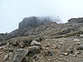
The mountain top (actually there are two peaks) has the shape of a chest or a suitcase ( span. Cofre ). It is built over with antennas.
The name comes from the town of Perote , which lies north of the Cofre de Perote. In addition, the mountain can be clearly seen from Xalapa . The name Cofre de Perote is also the name of the national park in which the mountain is located.
On some cold winter days in January and February, precipitation falls on the mountain top in the form of snow, which covers the mountain top in white for a few days.

Sunset in Xalapa (in the background the Cofre)
Western slope of the Cofre

Cofre as seen from the center of Xalapa

Cofre de Perote from Perote (north)


Web links
- Cofre de Perote in the Global Volcanism Program of the Smithsonian Institution (English)