Coolgardie
| Coolgardie | |||||||
|---|---|---|---|---|---|---|---|
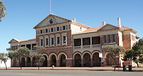
 Coolgardie Warden's Court |
|||||||
|
|||||||
|
|||||||
|
|||||||
|
|||||||
|
|
|||||||
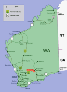
Coolgardie is a small town in Western Australia , 558 kilometers east of Perth in the Goldfields-Esperance region . This city has around 850 inhabitants today, but it was once the third largest city in Western Australia with 15,000 inhabitants after Perth and Fremantle when the gold rush at the end of the 19th century brought numerous gold miners there. Today this place is known to most of the residents of Western Australia as a tourist and ghost town.
history
On September 17, 1892 Arthur Bayley and his partner William Ford brought 554 ounces of gold (15.7 kg) to Southern Cross , which he had found in the area of Coolgardie. Hundreds of gold miners were already in the gold fields of Coolgardie in November and founded the city. By 1898 when it was the third largest city in Australia, it had a population of approximately 15,000 people; another 10,000 in the area were added. 700 Coolgardie mining companies were then registered on the London Stock Exchange . The town had numerous shops and had been accessible by rail since 1896. The place had a swimming pool, the first public bath in the state, many hotels, and some magazines. A sufficient water supply was only possible in 1903 through the Golden Pipeline .
Coolgardie was significant to the colony of Western Australia in the 1890s because it enabled the colony to become an Australian state. The eastern colonies around Coolgardie and other regional gold fields, such as Kalgoorlie-Boulder , wanted to establish a new state called Aurlia in the event the Perth government did not approve a referendum on a state. The then Western Australian government, however, reluctantly approved the referendum. The referendum was held precisely at the time when Western Australia was about to become a state. Coolgardie was at the time of the election in 1901 the center of the state constituency, the Division of Coolgardie . Soon after the November 1901 election, it was announced that Alf Morgans had been elected Prime Minister of Western Australia; and Albert Thomas was elected in the southern constituency of Coolgardie.
When gold ran out in the early 1900s, the city became depopulated; this trend continued with the First World War . The state constituency was closed in 1913 due to the population drop, as many of the residents had moved to other places with greater gold deposits. As a result, the place lost the status of a city. This development continued through the 20th century and the population dropped to less than 200 people; the city became a ghost town. An example of the decline is that in March 1896 the main street of Coolgardie was lit by electric light, but in April 1924 this street was only lit by four oil lamps. Regardless, many of the buildings that were built when urban development was at its peak have been preserved, and after a few years of regression there has been a reawakening of the city. The reason was tourism, which developed there and created jobs in the city, which caused the population to increase slightly.
Afghan camel guides
When the gold rush intensified from 1884 onwards, Afghan camels were used for supplies, because otherwise the gold fields could not be adequately supplied with food and water. In March of that year a caravan of six Afghans, 45 camels and eleven calves set off and was driven through the desert of Marree to the gold fields. All camels reached the gold fields in good condition and each camel carried loads of 135 to 270 kilograms. Another 85 camels for transports to Coolgardie reached Albany by ship in September.
By 1898 the Muslim community in Coolgardie had 300 members and an average of 80 of them attended the Friday sermon. The place had the largest Muslim community in this state at that time. There was not a Muslim woman among them, no marriage and no funeral was organized, this marked the relatively young, unmarried and changing community. The Muslims only had a mosque built with clay and covered with a tin roof. Racism against Afghan cameleers was widespread and there were reports of unsolved murders and torture of Afghan camels.
With the city's decline, the entire Muslim community probably moved to Perth, the emerging capital of the new state.
nowadays
"Coolgardie Day" takes place every year in Coolgardie during the Kalgoorlie Race Round season. On this day, attractions from the city and the mines are presented. The Coolgardie Rock Drilling Championships have recently started, in which miners compete against each other by drilling through a rock with a pneumatic hammer drill. Well-known champions of the Australian wood chopping competitions also take part in this competition.
Coolgardie is today again the center of an administration, the Shire of Coolgardie . Multilingual historical explanations are placed in the city to inform tourists about important places. There are several museums, a visitor center, the old train station and Warden Finnerty's Residence, owned by the National Trust of Australia .
Streets
The Great Eastern Highway and National Highway 94 run through the city as Bayley Road, named after Arthur Bayley , the city-region's first gold discoverer . In the east of the city, Highway 94 changes to the Coolgardie-Esperance Highway , which continues to Norseman , the starting point for crossing the Nullarbor Plains .
The Transwa Prospector train stops 14 kilometers north of the city at Bonnie Vale.
Gold fields
In the 1890s there were four gold fields in Coolgardie that were mined:
- Coolgardie Gold Field (1894)
- Eastern Coolgardie Gold Field (1894)
- Northern Coolgardie Gold Field (1895)
- Northeastern Coolgardie Gold Field (1896)
Despite the decline of the Kalgoorlie region, there is still a mine registry in Coolgardie.
Web links
Individual evidence
- ^ Australian Bureau of Statistics : Coolgardie (L) (Urban Center / Locality) ( English ) In: 2016 Census QuickStats . June 27, 2017. Retrieved April 7, 2020.
- ^ Morris, Bernie & Milne, Rod: Coolgardie's Railway Days in Australian Railway History, pp. 183-196; 219–234, June / July 2008
- ↑ Archived copy ( memento of the original dated November 30, 2007 in the Internet Archive ) Info: The archive link was inserted automatically and has not yet been checked. Please check the original and archive link according to the instructions and then remove this notice.
- ↑ Archived copy ( memento of the original from January 26, 2016 in the Internet Archive ) Info: The archive link was inserted automatically and has not yet been checked. Please check the original and archive link according to the instructions and then remove this notice.
- ↑ http: www.islamfortoday.com/australia03.htm Archive link ( Memento of the original from October 15, 2008 in the Internet Archive ) Info: The archive link was inserted automatically and has not yet been checked. Please check the original and archive link according to the instructions and then remove this notice.
- ↑ Archive link ( Memento of the original dated August 30, 2008 in the Internet Archive ) Info: The archive link was inserted automatically and has not yet been checked. Please check the original and archive link according to the instructions and then remove this notice.


