
Crawley
| Borough of Crawley | |||
|---|---|---|---|
 |
|||
| Coordinates | 51 ° 7 ′ N , 0 ° 12 ′ W | ||
| OS National Grid | TQ268360 | ||
|
|||
| Residents | 108,302 (as of 2012) | ||
| surface | 44.96 km² (17.36 mi² ) | ||
| Population density | 2409 | ||
| administration | |||
| Post towns | HORLEY, GATWICK CRAWLEY |
||
| ZIP code section | RH6 RH10-11 |
||
| prefix | 01293 | ||
| Part of the country | England | ||
| region | South East England | ||
| Shire county | West Sussex | ||
| Ceremonial county | West Sussex | ||
| District | Crawley | ||
| British Parliament | Crawley | ||
| Website: www.crawley.gov.uk | |||

Crawley [ ˈkɹɔːli ] is a town in West Sussex in England and is located around 30 km south of London in the immediate vicinity of Gatwick Airport .
history
After the area had been settled since the Stone Age, the establishment of an iron industry began with the conquest of England by the Romans around Crawley. The Anglo-Saxons called the place Craw leah , which means something like "clearing populated by crows"; here the parishes of Ifield and Worth , both of which are mentioned in the Domesday Book , arose . In 1203 Worth received the right to hold a weekly market.
Crawley's boom only began when a railway junction was built here in 1848 : in Crawley, the line to Horsham has since branched off from the London– Brighton line . In 1891 a racecourse was built in neighboring Gatwick , and an airfield was added in the 1930s , which, along with Heathrow, developed into the most important airport in Greater London. By the Second World War, the population had risen to 10,000. The development was further promoted with the connection to the M23 motorway .
In 1947 Crawley received the status of a " New Town ", a kind of planned town that received special funding. As a result, the population grew rapidly, so that Crawley already had 60,000 inhabitants in the 1960s. Several neighboring communities were incorporated into the urban area. Crawley, the city with the lowest unemployment rate in the United Kingdom, continued to grow in the 1980s .
Crawley's German twin town is Dorsten .
City structure
The following districts belong to Crawley ( English Neighborhoods ):
- Bewbush
- Broadfield
- Forge Wood
- Furnace Green
- Gossops Green
- Ifield
- Langley Green
- Maidenbower
- Northgate
- Pound Hill
- Southgate
- Tilgate
- Three bridges
- West Green
Buildings
One hundred structures in the Borough of Crawley have been classified as Listed Buildings by English Heritage . These include the White Hart Inn , Ancient Priors and Old Punch Bowl or the first integrated terminal building at Gatwick Airport , The Beehive . Of these hundred structures, three are Grade I - the parish churches of St Margaret in Ifield and St Nicholas in Worth and the Qaker meeting house in Ifield; the Grade II * classified twelve buildings, the remaining 85 structures correspond to the Grade II .
Personalities
Born here
- Kevin Vincent Muscat (born 1973), Australian soccer player
- Katie-George Dunlevy (* 1991), Irish paracycler
Lived in Crawley
- Mark Lemon (1809–1870), the first editor of Punch
- John George Haigh (1909–1949), a notorious serial killer
- Lucy Brown , writer
- Peter Vaughan (1923-2016), actor
- The Cure , rock band formed in Crawley in 1976
- Gareth Southgate (* 1970), soccer player and coach
- Chris Stewart (* 1951), former drummer for the band Genesis
- Hermione Jean Granger , fictional character and member of the Golden Trio
gallery

St. John's Church
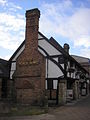
Old Punch Bowl
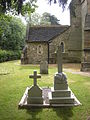
Old graveyard
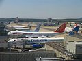
Gatwick Airport


Individual evidence
- ↑ Population of England and Wales on June 30, 2012 ( ZIP ; 832 kB)
- ↑ Listed Buildings in Crawley (PDF) In: Crawley Borough Council website: Listed Buildings in Crawley . Crawley Borough Council. 2008. Retrieved July 10, 2010.