Dalton (Georgia)
| Dalton | |
|---|---|
| Nickname : Carpet Capital of the World | |
 Joseph E. Johnston's Memorial in Dalton, Georgia |
|
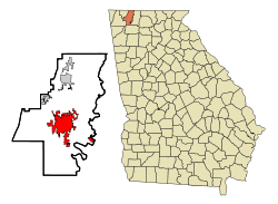
| Location of Dalton in Georgia | |
| Basic data | |
| Foundation : | 1847 |
| State : | United States |
| State : | Georgia |
| County : | Whitfield County |
| Coordinates : | 34 ° 46 ′ N , 84 ° 58 ′ W |
| Time zone : | Eastern ( UTC − 5 / −4 ) |
|
Inhabitants : - Metropolitan Area : |
34,077 (as of 2016) 143,904 (as of 2016) |
| Population density : | 664.3 inhabitants per km 2 |
| Area : | 51.3 km 2 (approx. 20 mi 2 ) |
| Height : | 232 m |
| Postcodes : | 30719-30722 |
| Area code : | +1 706 |
| FIPS : | 13-21380 |
| GNIS ID : | 0355424 |
| Website : | www.cityofdalton-ga.gov |
| Mayor : | Dennis Mock |
Dalton is a city and also the county seat of Whitfield County in the US state of Georgia with 33,128 inhabitants (as of 2010). The city is the hub of the Dalton metropolitan area .
geography
Dalton is located approximately 130 km northwest of Atlanta .
history
The city played a major role during the Atlanta campaign from May to September 1864, as Joseph E. Johnston used the Confederate Tennessee Army here at the beginning of the campaign against the armies of William T. Sherman . The Battle of Rocky Face Ridge took place from May 7th to May 13th. The construction of the Western and Atlantic Railroad was of great importance for the growth of the city , as, among other things, a railway depot was established.
Demographic data
According to the 2010 census, the then 33,128 inhabitants were distributed among 11,337 inhabited households, which gives an average of 2.84 people per household. There are a total of 13,378 households.
66.9% of households were family households (consisting of married couples with or without offspring or one parent with offspring) with an average size of 3.51 people. Children under the age of 18 lived in 41.0% of all households and persons aged 65 or over in 22.1% of all households.
32.7% of the population were younger than 20 years, 29.4% were 20 to 39 years old, 23.2% were 40 to 59 years old, and 14.9% were at least 60 years old. The mean age was 31 years. 49.3% of the population were male and 50.7% were female.
65.0% of the population identified themselves as whites , 6.4% as African American , 0.6% as Indians and 2.4% as Asian Americans . 22.3% said they belonged to another ethnic group and 3.2% to several ethnic groups. 48.0% of the population were Hispanics or Latinos .
The average annual income per household was 34,682 USD , while 24.5% of the population lived below the poverty line.
Town twinning
Attractions
The following properties are listed on the National Register of Historic Places :
traffic
Dalton is crossed by Interstate 75 , US Highways 41 and 76, and Georgia State Routes 52 and 71 . Passenger traffic on the Atlanta – Chattanooga line was discontinued on April 30, 1970. Today the route is used by CSX for freight traffic. The local airfield Dalton Municipal Airport is ten kilometers southeast of the city area. The nearest international airport is Chattanooga Metropolitan Airport (around 40 km northwest).
crime
The crime rate in 2010 was 237 points (US average: 266 points) in the average range. There were four rapes, 27 robberies, 45 assaults, 285 break-ins, 838 thefts, 59 car thefts and four arson attacks.
sons and daughters of the town
- Harlan Erwin Mitchell (1924–2011), politician
- Jackie Lee Cochran (1934–1998), rockabilly musician
- Mike Erwin (* 1978), actor
- Saul Raisin (* 1983), racing cyclist
- Morris Almond (born 1985), basketball player
Web links
- Website of the city (Engl.)
Individual evidence
- ^ History of Dalton Georgia. Retrieved March 29, 2018 .
- ^ Profile of General Population and Housing Characteristics: 2010 . United States Census Bureau . Retrieved March 29, 2018.
- ↑ GEORGIA - Whitfield County. National Register of Historic Places , accessed March 29, 2018 .
- ↑ http://www.city-data.com/crime/crime-Dalton-Georgia.html
