Darende
| Darende | ||||
|
||||

|
||||
| Basic data | ||||
|---|---|---|---|---|
| Province (il) : | Malatya | |||
| Coordinates : | 38 ° 33 ' N , 37 ° 31' E | |||
| Height : | 958 m | |||
| Residents : | 9,165 (2008) | |||
| Telephone code : | (+90) 422 | |||
| Postal code : | 447xx | |||
| License plate : | 44 | |||
| Structure and administration (status: 2009) | ||||
| Mayor : | İsa Özkan ( AKP ) | |||
| Website: | ||||
| Darende district | ||||
| Residents : | 35,341 (2008) | |||
| Surface: | 1,363 km² | |||
| Population density : | 26 inhabitants per km² | |||
| Kaymakam : | Murat Uzunparmak | |||
| Website (Kaymakam): | ||||
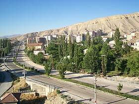
Darende is a town and capital of the district of the same name in the Turkish province of Malatya . Darende County is in the east of the province and borders the Kahramanmaraş and Sivas provinces . 9,165 people live in the city of Darende and 35,341 people in the entire district (as of 2008).
Attractions
The Tohma Çayı flows through Darende in a southerly direction. Rafting is available on the river north of town . The waterfalls of Gürpınar , which are a popular destination, are located in a valley west of the district town . About 15 kilometers to the southwest is the late Hittite monument Arslantaş , which shows two free-standing lions in an open field. Near the village of Balaban, about 30 kilometers downstream on Tohma Çayı, there is also the late Hittite rock inscription from Kötükale , which is, however, buried today. The Darende and İspekçür steles were found in the vicinity of the city and are now in the museums of Ankara and Sivas .
sons and daughters of the town
- Ahmet Çakır (* 1964), politician (AKP)
Web links
Individual evidence
- ↑ a b Turkish Institute for Statistics ( Memento from December 5, 2012 in the web archive archive.today ), accessed November 21, 2009


