Dassower See
| Dassower See | ||
|---|---|---|
|
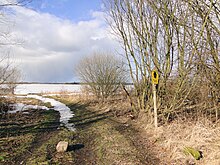
View over the Dassower See bay (1990) |
||
| Waters | Trave ( Lower Trave ) | |
| Geographical location | 53 ° 54 '37 " N , 10 ° 55' 42" E | |
|
|
||
| width | 3 km | |
| depth | 5.6 km | |
| surface | 7.84 km² | |
| Medium water depth | 2.5 m | |
| Islands | Buchhorst, Graswerder | |
| Tributaries | Stepenitz | |
The Dassower lake is despite its name, not a lake , but a side bay ( Wiek ) of Travelodge Fjord , five kilometers above the Trave estuary to the Baltic Sea .
The river bay is located northeast of the built-up urban area of Lübeck ( Schleswig-Holstein ) in close proximity to the Baltic Sea, to the north the Priwall peninsula connects with the “ Südlicher Priwall ” nature reserve . Legally, the area is part of the Trave federal waterway with a length of around 5.5 kilometers to the southeast end near Dassow in the responsibility of the Lübeck Waterways and Shipping Office .
geography
The Dassower See is a brackish water bay in the river Trave , which, together with the Pötenitzer Wiek, is separated from the open sea of the Lübeck Bay by the Priwall peninsula . The approximately 8 km² large Dassower See has a funnel-like shape starting from the mouth of the Stepenitz River in the southeast, which narrows again to around 300 meters in the northwest (confluence with the Pötenitzer Wiek). At the mouth of the Stepenitz, there is a small pier for the fishing boats from Dassow at the Dassower Bridge .
The lake belongs to the urban area of Lübeck, the entire shoreline forms the border with Mecklenburg-Western Pomerania . The eponymous small town Dassow in the district of Northwest Mecklenburg is the only larger settlement on Dassower See, on the northern bank is the former manor of Johannstorf Castle .
history
Until German reunification , the entire lakeshore area was restricted and thus withdrawn from tourism and any development. On the banks of the GDR there was a wall several meters high made of concrete elements, so that the lake could not be seen from the GDR side. Entering the exclusion zone was only possible with a special permit. The water surface of the lake could be navigated from the Trave (the border ran along the flood line, so that at normal water level a narrow strip of shore belonged to Schleswig-Holstein and thus to the Federal Republic).
Flora, fauna and nature conservation

Home to around 30 species of duck , the Dassower See is one of the largest bird sanctuaries in Germany. The lake with the two islands Buchhorst and Graswerder (Plönswerder) as well as its reed stocks is also an important resting and wintering area for Nordic water birds. The Dassower See and its bank areas have been under nature protection since 1983 (nature reserve Dassower See, islands Buchhorst and Graswerder (Plönswerder) ) and are registered as an FFH area to the European Union . On the Mecklenburg side, the adjacent bank areas were placed under protection through the designation of the nature reserve Uferzone Dassower See in 1990. The coastal landscape nature reserve between Priwall and Barendorf with the Harkenbäkniederung joins on the north bank .
See also
literature
- Gottfried Renatus Häcker : Lübeck flora. Aschenfeldt, Lübeck 1844 (digitized version)
- Manfred Diehl, Dorothea Diehl: Nature reserves on the Baltic Sea coast of Schleswig-Holstein . In: Reports of the association “Nature and Homeland” and the Natural History Museum in Lübeck , issue 19/20, 1986, ISSN 0067-5806
Web links
- Nature reserve "Dassower See, islands Buchhorst and Graswerder (Plönswerder)", information from the Hanseatic City of Lübeck. (No longer available online.) Formerly in the original ; accessed on March 7, 2020 . ( Page no longer available , search in web archives )
Individual evidence
- ↑ Directory E, serial no. 58 der Chronik ( Memento of the original from July 22, 2016 in the Internet Archive ) Info: The archive link has been inserted automatically and has not yet been checked. Please check the original and archive link according to the instructions and then remove this notice. , Federal Waterways and Shipping Administration
- ↑ Lengths (in km) of the main shipping routes (main routes and certain secondary routes) of the federal inland waterways ( memento of January 21, 2016 in the Internet Archive ), Federal Waterways and Shipping Administration
- ↑ Nature Conservation Ordinance .
- ↑ Mecklenburg-Western Pomerania Ministry of the Environment (Ed.): The nature reserves in Mecklenburg-Western Pomerania , ISBN 3-910150-52-7 , p. 452 f.

