
Danube Park


The Donaupark is a 604,000 m² park in the 22nd district of Vienna, Donaustadt .
location
The Donaupark is conveniently located between Wagramer Strasse, the Bruckhaufen settlement , Arbeiterstrandbadstrasse and Hubertusdamm. The UNO-City with the Vienna International Center and the Austria Center Vienna are directly connected to the Danube Park, which originally extended as far as Wagramer Straße , to the south of it the Danube City and then with the Danube Island to the New Danube, the former Copa Cagrana, since 2018 as Copa Beach advertised. In the north, the Danube Park with the bathing beaches along the Upper Old Danube is limited.
history


Firing range
Between 1871 and 1945 the Kagran firing range existed here for target practice by the military; it took up a large area of today's Danube Park. During the Nazi era, it was also used for numerous executions. In the north, not far from the China restaurant, there is a memorial plaque to the murdered, which was unveiled on November 5, 1984. A commemorative event is held every year around October 27th.
landfill
From 1880 to 1964, large parts of the area of today's Danube Park were used as a garbage dump . First, the intermediate bridges gasworks stored coke on the Bruckhaufen. From 1892 on, private transport companies also deposited garbage on the site. So-called rascals and coke bulls searched him for recyclable waste. In 1923, waste disposal was reorganized by the city administration. The garbage was loaded onto trucks at a ramp , which distributed it over an extensive network of tracks on the Bruckhaufen. The waste recycling was now carried out by own tenants before the waste was compacted by road rollers . The landfill repeatedly reached the limits of its capacity and had to be enlarged. In April 1958, Mayor Franz Jonas informed the population that the city would switch from landfilling to incineration . The Flötzersteig waste incineration plant was inaugurated in 1962 , but rubbish was dumped on the Bruckhaufen until 1964.
Bretteldorf
In addition, the settlements Bruckhaufen and Bretteldorf, which were illegally built on leased land for allotment gardens in the early 20th century, existed . The former wetland, in which sand was partially extracted, was up to eight meters deeper than the surrounding area and was regularly flooded by the rising groundwater level during floods. The initially simple huts that were erected there despite the building ban were gradually replaced by more robust dwellings. For the settlement, which grew rapidly during the First World War, a chapel was built on Wagramer Strasse in 1917, which was popularly known as the “ Russenkircherl ” because of the Russian prisoners of war involved in the construction . In 1925, a commission from several municipal departments called for construction to be halted and for unfinished buildings to be demolished in return for an infrastructural upgrade of the settlement. The settlers, who saw themselves as part of the settler movement , opposed this. The press reported extensively on the “Bretteldorfer War”. Finally, the city revoked the demolition request. Due to a change in the zoning plan , the Bruckhaufen settlement was legalized in 1929, but not the Bretteldorf. In 1935 the municipality of Vienna bought the area on which the settlement was located from Klosterneuburg Abbey . At that time, around 1000 people lived there in 374 buildings. Since the landfill at the height of today's Danube Tower was full, around 100 settler families were resettled in 1937 to make space for new garbage dumps. Around 1950 there was a further expansion of the landfill and the corresponding termination of leases. The last settler families were also resettled by 1963.
Establishment of the park
After renovation, the site offered itself as a recreational area , as it is only 4 km as the crow flies from the city center and close to the main traffic axis at the Reichsbrücke . The City of Vienna decided to build the park in connection with an international garden show . The then city garden director Ing. Alfred Auer was commissioned with the overall planning .
On April 16, 1964, the Danube Park was opened together with the Danube Tower on the occasion of the Vienna International Garden Show ( WIG 64 ). The Donauparkhalle was also built. A chair lift and a narrow-gauge railway operated until the 1980s were used to transport exhibition visitors. In addition, a floating stage was created and there was a separate cinema. The high-rise buildings, especially the Seerestaurant (today's Korea Kulturhaus Wien ) were planned by Kurt Schlauss .
The area was also referred to as the WIG site and later the old WIG (in contrast to the WIG 74 in the Oberlaa Kurpark ). Today, only a few remains of the elaborate park furniture from the 1960s can be seen.
In 1983 Pope John Paul II celebrated a holy mass on the occasion of the Catholic Day on a 20 hectare part of the Danube Park near the Danube Tower , later called Papstwiese , and attended by around 300,000 believers. For this purpose, the so-called Pope's Cross was erected, which remained as a temporary measure and was renovated in 2011.
The only superficial renovation of the former landfill already led to problems during the garden show: landfill gas leaked in some places , some wells were contaminated and had to be shut down. In 1990 the Donaupark-Bruckhaufen area was classified as a priority 2 site (medium urgency). In the course of the construction of the Donau City , the urgently needed renewal of the areas of the former landfill was also carried out. A system of locking wells established in 1993 prevents polluted groundwater from seeping into the Old Danube .
In 1993 the iris lake, lined with old silver poplars , was renatured . The extracted and oxygen-enriched groundwater now flows through it. Rushes , sedges , cattails , Flowering and other plants form a kind of biological wastewater treatment plant . The clarified water is then fed into the Danube.
Infrastructure

The Donaupark can be easily reached by public transport, by bike and by car. With the U1 line via the Alte Donau or Kaisermühlen / VIC stations or with the bus lines 20B, 90A, 91A and 92A. The Donaupark is well connected to the Viennese cycle path network. The park can also be reached by car via the Reichsbrücke and Brigittenauer Brücke . There is a small parking lot right next to the Danube Tower, larger parking spaces are available along Arbeiterstrandbadstraße, the largest of which is at the intersection with Donauturmstraße.
The range of leisure activities in the park is diverse. There are playgrounds, skate parks and public tennis courts. With the Donauparkbahn , a park railway with a 381 millimeter gauge, you can make a 3.3 kilometer round trip through the park. On the Donaupark stage , concerts are offered free of charge in the summer months, organized by the Donaustadt cultural association.
Attractions
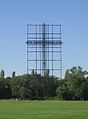
- Danube Tower
- Memorial plaque for the victims of the Nazi military justice 1938–1945
- Monuments to Salvador Allende , José Martí , José de San Martín , Simón Bolívar , Che Guevara , José Gervasio Artigas and to the composer Üzeyir Hacıbəyov
- Several sculptures
- Memorial stone for Paracelsus
- Pope Cross
- Donauparkbahn
- Leherb mosaic
- Korean culture house
- Sichuan Chinese restaurant with a Chinese garden

Salvador Allende

José Martí

José de San Martín

Simón Bolívar

Che Guevara

Üzeyir Hacibəyov
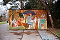
Mosaic "In the Café" by Leherb
The Pope's Cross

Sculpture "King and Queen" by Kurt Goebel

Sculpture group "The Golden Calf" by Karl Anton Wolf

Irissee, in the background the IZD Tower

Korean culture house on Lake Iris

Cascades at the rosarium

Floor chess game by Susanne Peschke-Schmutzer

Stage in the Danube Park


_Vienna_International_Centre.jpg)


literature
- TIG opens today. President sharpening opened the flower show - From 13:00 to open gates . In: Arbeiter-Zeitung . Vienna April 16, 1964, pages 1 and 5 .
- The WIG opens - 25,000 on the first day. Dr. Schärf: "Paradise in a nutshell" . In: Arbeiter-Zeitung . Vienna April 17, 1964, pages 1 and 5 ( main attraction: flowers, Danube tower, small train ) .
- Robert Schediwy , Franz Baltzarek: Green in the big city - history and future of European parks with special consideration of Vienna. Vienna 1982, ISBN 3-85063-125-7
- Franz Loidl : Unveiling of memorial stone for resistance fighters, soldiers and firefighters at the Kagran shooting range on November 5, 1984. In: Miscellanea series of the Vienna Catholic Academy . Row 3, No. 38, Vienna 1984.
- Herbert Exenberger : Antifascist city guide. Vienna 1985, pp. 76-77.
- Franz Loidl : Macabre commemoration around the Kagran shooting site after 40 years. In: Miscellanea series of the Vienna Catholic Academy. Row 3, No. 188, Vienna 1987.
- Herbert Exenberger, Heinz Riedel: Kagran military shooting range. In: Series of publications by the Documentation Archive of Austrian Resistance (DÖW) on the history of Nazi violent crimes. Vol. 6, Vienna 2003, pp. 7–97.
- Lilli Licka, Ulrike Krippner: 50 years of the Danube Park: urban planning vision and dimension. ("Study on the urban planning visions and strategies that led to the realization of the Vienna International Garden Show WIG 64 and the establishment of the Danube Park.") Ed. University of Natural Resources and Life Sciences, Vienna, Institute for Landscape Architecture, on behalf of Municipal Department 18 - Urban Development and Urban Planning. Vienna, 2011. (full text as PDF; 51 pages ).
Web links
- Danube Park in the Vienna History Wiki of the City of Vienna
- The Danube Park at wien.gv.at.
- Donauparkbahn
- Information ( memento of April 3, 2014 in the Internet Archive ) on the exhibition about the WIG 64 in the Wien Museum 2014
Individual evidence
- ^ The Vienna Pope's Cross will be renovated this year , Die Presse , February 4, 2011. Accessed February 7, 2011.
- ↑ OLD LOAD W10: WIG 64 (Donaupark-Bruckhaufen). Umweltbundesamt , 2018, accessed on 10 September 2018 (date of text creation: March 1990).
- ↑ The Danube Park. Vienna City Hall, City Hall, accessed on September 10, 2018 .
- ↑ Stage Donaupark 2010 on wien.gv.at, city hall correspondence of July 8, 2010.
- ↑ En el Austria celebraron natalicio de Artigas. In: El Observador . June 19, 2013, Retrieved September 9, 2018 (Spanish).
Coordinates: 48 ° 14 ′ 24 ″ N , 16 ° 25 ′ 4 ″ E