
Eckbachweiher
| Eckbachweiher | ||
|---|---|---|

|
||
| The Eckbachweiher (view towards the dam) | ||
| Geographical location | Palatinate Forest ( Rhineland-Palatinate ) | |
| Tributaries | Eckbach | |
| Drain | Eckbach | |
| Places on the shore | Neuleiningen valley | |
| Location close to the shore | Newcomers | |
| Data | ||
| Coordinates | 49 ° 32 '22 " N , 8 ° 7' 55" E | |
|
||
| Altitude above sea level | 180 m above sea level NHN | |
| length | 560 m | |
| width | 32 m | |
|
particularities |
formerly a reservoir for two mills |
|

The Eckbachweiher in the Palatinate Leiningerland ( Rhineland-Palatinate ) is a woog of the Eckbach . Woog are mainly known as artificial reservoirs in southwest Germany .
geography
The Eckbachweiher is located in the northeast of the Palatinate Forest at about 180 m above sea level. NHN in the district of the hamlet Neuleiningen-Tal , which belongs to the community of Leiningerland . The body of water stretches from southwest to northeast along the valley road, which is identical to state road 520 ( Carlsberg - Kleinkarlbach ).
history
The reservoir was created in the Middle Ages in a smaller form as a water reservoir for two mills below. In the 1870s, the dam was increased to increase the filling volume of the lake. The Eckbachtal was thus better protected against floods , which could occur especially in spring after snowy winters. Today the length of the reservoir is 560 m, its maximum width 32 m.
The Eckbachweiher ensured the operation of the two mills even in dry periods. The upper mill directly below the dam went down. The Felsenmühle 800 m to the east is a large, well restored and attractively supplemented building complex, which is grouped around a paved inner courtyard and is operated as a hotel-restaurant.
Sights and culture
The Eckbachweiher is known among biologists as a retreat for the native dragonfly fauna and also offers a habitat for endangered species such as the little mosaic damsel (Brachytron pratense).
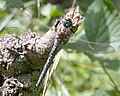
Little maiden of the mosaic

Eckbach mill hiking trail


The 23 km long Eckbach-Mühlenwanderweg also runs along the Eckbachweiher . It connects 23 mills in the region, some of which have been restored. About 2 km east of the pond, to the left and right above the exit of the Eckbachtal towards the Rhine plain , lie the castles Neuleiningen and Battenberg on two foothills of the low mountain range Leininger Sporn , which used to belong to the noble family of the Leininger and protected the valley entrance. At Altleiningen Castle , 3 km southwest of the pond , the family seat of the family, performances of the Altleiningen Castle Games take place during the summer months .
On the hillside south of the pond is the historic Neuleiningen washing area from the 19th century, one of the few remaining facilities of this type.
Individual evidence
- ↑ a b Map service of the landscape information system of the Rhineland-Palatinate Nature Conservation Administration (LANIS map) ( notes )
- ↑ Eckbachweiher. Bathing lakes in Germany, accessed on October 19, 2011 .
- ↑ Eckbachweiher. (No longer available online.) Google Earth, archived from the original on October 29, 2013 ; Retrieved October 19, 2011 . Info: The archive link was inserted automatically and has not yet been checked. Please check the original and archive link according to the instructions and then remove this notice.
- ↑ Planning of networked biotope systems, Bad Dürkheim district, city of Neustadt. (No longer available online.) Ministry for the Environment Rhineland-Palatinate and State Office for Environmental Protection and Trade Supervision (Ed.), February 1998, p. 216 , archived from the original on October 29, 2013 ; Retrieved on October 19, 2011 (Chapter D.2.2.5 Planning Unit 5: Leininger Sporn ). Info: The archive link was inserted automatically and has not yet been checked. Please check the original and archive link according to the instructions and then remove this notice.