
Elbe Valley (Hesse)
| coat of arms | Germany map | |
|---|---|---|
.png)
|
Coordinates: 50 ° 30 ' N , 8 ° 3' E |
|
| Basic data | ||
| State : | Hesse | |
| Administrative region : | to water | |
| County : | Limburg-Weilburg | |
| Height : | 176 m above sea level NHN | |
| Area : | 11.11 km 2 | |
| Residents: | 2393 (Dec. 31, 2019) | |
| Population density : | 215 inhabitants per km 2 | |
| Postal code : | 65627 | |
| Area code : | 06436 | |
| License plate : | LM, WEL | |
| Community key : | 06 5 33 005 | |
| Address of the municipal administration: |
Rathausstrasse 1 65627 Elbe Valley |
|
| Website : | ||
| Mayor : | Joachim Lehnert ( independent ) | |
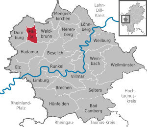
| Location of the Elbtal community in the Limburg-Weilburg district | ||
  |
||

Elbe Valley is the smallest municipality in the Limburg-Weilburg district in Central Hesse .
geography
location

Elbe valley lies on the southern slope of the Westerwald above the Lahn valley .
structure
The community consists of the four districts of Dorchheim (seat of the municipal administration), Elbgrund , Hangenmeilingen and Heuchelheim .
history
The hills on both sides of the Elbe stream were inhabited as early as the Neolithic ; Numerous finds of stone tools prove this. The ring wall system " Heidenhäuschen " near Hangenmeilingen is dated to the Hallstatt period (750 to 450 BC).
Heuchelheim was first mentioned in 772 in a deed of donation from the Lorsch monastery , Waldmannshausen, one of the predecessor communities of Elbgrund, on October 21, 1138 as part of a donation to the St. Goar monastery , Dorchheim 1215 in a deed from the Maria Laach monastery , Mühlbach, the second Predecessor parish of Elbgrund, 1230 in a donation from the Counts of Nassau to the Teutonic Order and Hangenmeilingen on January 21, 1333.
The moated castle Waldmannshausen in Elbgrund, still preserved today, was the seat of the Walpoden in the Middle Ages , who had jurisdiction over the surrounding area. The complex has a late Gothic house with two round towers and farm buildings that are still in use today. To the west of it are the ruins of an older, circular castle. In 1835 the castle came into the possession of the important Frankfurt banking family Bethmann . After the Second World War it was the headquarters of the US Army . Today it is used as a school camp.
One of the oldest buildings in the community is the Marienstätter Hof in Dorchheim, which has been used as the Elbe valley town hall since 1993. The exact year of construction is unknown. It is one of three remaining farms that belonged to the Marienstatt monastery .
Until the middle of the 20th century, clay and basalt were mined in the Mühlbach district.
Incorporations
On February 1, 1971, as part of the regional reform in Hesse, the places Dorchheim , Hangenmeilingen and Heuchelheim merged to form a municipality called the Elbe Valley . On July 1, 1974, the then still independent municipality of Elbgrund was added by state law, which had been formed in 1936 from the previously independent municipalities of Mühlbach and Waldmannshausen.
Community representation
The local elections on March 6, 2016 produced the following results, compared to previous local elections:
| Parties and constituencies | % 2016 |
Seats 2016 |
% 2011 |
Seats 2011 |
% 2006 |
Seats 2006 |
% 2001 |
Seats 2001 |
||
|---|---|---|---|---|---|---|---|---|---|---|
| CDU | Christian Democratic Union of Germany | 38.1 | 6th | 32.6 | 5 | 43.2 | 7th | 41.3 | 6th | |
| BLE | Citizens List Elbe Valley | 34.6 | 5 | 28.9 | 4th | - | - | - | - | |
| SPD | Social Democratic Party of Germany | 27.3 | 4th | 27.7 | 4th | 27.1 | 4th | 25.3 | 4th | |
| FWG | Free electoral community Elbe Valley | - | - | 10.9 | 2 | 13.5 | 2 | 13.8 | 2 | |
| FBH | Free list of citizens Hangenmeilingen | - | - | - | - | 9.4 | 1 | 10.0 | 2 | |
| BLD | Citizen list Dorchheim | - | - | - | - | 6.8 | 1 | 9.6 | 1 | |
| total | 100.0 | 15th | 100.0 | 15th | 100.0 | 15th | 100.0 | 15th | ||
| Voter turnout in% | 47.5 | 45.9 | 45.6 | 57.0 | ||||||

Attractions
- Waldmannshausen moated castle
- Chapel of St. Nicholas in the Dorchheim cemetery
- Built at the beginning of the 12th century, rebuilt in the 16th century, the central pillar is richly carved, the choir has a cycle of paintings.
Economy and Infrastructure
Elbe Valley is a residential community, besides the local trade and craft there is no industry.
traffic
The community is located on the Bundesstrasse 54 Siegen - Limburg and is therefore well connected to the trunk road network.
education
There is a joint elementary school in the community with the Elbe Valley School in Dorchheim . The secondary schools usually go to the St. Blasius School in Frickhofen and the Fürst-Johann-Ludwig-School in Hadamar .
Facilities
- Kindergarten Elbtal Sonnenblume in Dorchheim
- Kindergarten Elbtal St. Josef in Dorchheim
- Volunteer fire brigade Elbtal (merger of the former volunteer fire brigades Dorchheim, Hangenmeilingen, Elbgrund and Heuchelheim)
- Elbe Valley Youth Fire Brigade
- Elbe Valley Children's Fire Brigade
societies
- Volunteer Fire Brigade Dorchheim eV (founded 1895)
- Voluntary Fire Brigade Elbgrund eV (founded 1934)
- Volunteer Fire Brigade Hangenmeilingen eV (founded 1934)
- Heuchelheim Volunteer Fire Brigade Association (founded 1934)
- History and culture group Elbtal eV
- Citizens' Association Elbtal eV
- Musikverein Elbtal-Musikanten eV
- FSV Hangenmeilingen eV
- TTC Dorchheim / Hangenmeilingen
- Modellsportclub Elbtal eV
- Spielgemeinschaft SG Nord
- Friends of the Elbe Valley School eV
Individual evidence
- ↑ Hessian State Statistical Office: Population status on December 31, 2019 (districts and urban districts as well as municipalities, population figures based on the 2011 census) ( help ).
- ^ Municipal reform: mergers and integration of municipalities from January 20, 1971 . In: The Hessian Minister of the Interior (ed.): State Gazette for the State of Hesse. 1971 No. 6 , p. 248 , para. 14 ( online at the information system of the Hessian state parliament [PDF; 6.2 MB ]).
- ↑ a b Federal Statistical Office (ed.): Historical municipality register for the Federal Republic of Germany. Name, border and key number changes in municipalities, counties and administrative districts from May 27, 1970 to December 31, 1982 . W. Kohlhammer, Stuttgart / Mainz 1983, ISBN 3-17-003263-1 , p. 369 .
- ↑ Law on the reorganization of the Limburg district and the Oberlahn district. (GVBl. II 330-25) of March 12, 1974 . In: The Hessian Minister of the Interior (ed.): Law and Ordinance Gazette for the State of Hesse . 1974 No. 5 , p. 101 , § 1 ( online at the information system of the Hessian state parliament [PDF; 809 kB ]).
- ^ Result of the municipal election on March 6, 2016. Hessian State Statistical Office, accessed in April 2016 .
- ^ Hessian State Statistical Office: Result of the municipal elections on March 27, 2011
- ^ Hessian State Statistical Office: Result of the municipal elections on March 26, 2006
Web links
- Website of the Elbtal community
- Elbe valley. Local history, information. In: www.elbtal.net. Private website
- Elbe Valley, Limburg-Weilburg district. Historical local dictionary for Hessen. In: Landesgeschichtliches Informationssystem Hessen (LAGIS).
- Information on the municipality of Elbtal. In: Hessisches Gemeindelexikon. HA Hessen Agentur GmbH , 2016.
- Literature about Elbe valley in the Hessian bibliography
- Link catalog on the Elbe Valley at curlie.org (formerly DMOZ )
- Integrated municipal development concept Elbe Valley. Urban development contribution. PDF.

Bad Camberg | Beselich | Breaking | Dornburg | Elbe Valley | Elz | Hadamar | Hünfelden | Limburg a. d. Lahn | Löhnberg | Mengerskirchen | Merenberg | Runkel | Selters (Taunus) | Villmar | Waldbrunn (Westerwald) | Weilburg | Weilmünster | Weinbach