
Elstertal Bridge
Coordinates: 50 ° 33 ′ 13 ″ N , 12 ° 10 ′ 4 ″ E
| Elstertal Bridge | ||
|---|---|---|
 |
||
| use | Rail transport | |
| Convicted |
Leipzig – Hof railway line ( Saxony-Franconia main line ) |
|
| Crossing of | Valley of the White Elster | |
| place |
Jocketa Saxony |
|
| construction | Arch bridge | |
| overall length | 279 m | |
| Number of openings | 9 (on the top floor) | |
| Longest span | 31.1 m | |
| height | 68 m in 2 floors | |
| start of building | November 7, 1846 | |
| completion | July 15, 1851 | |
| planner | Johann Andreas Schubert | |
| location | ||
|
||
|
||

The Elstertalbrücke is a railway bridge in Saxony . It transfers the railway line Leipzig – Hof near Jocketa (in the Saxon Vogtland district ) over the valley of the White Elster . After the Göltzschtalbrücke, it is the second largest brick bridge in the world. The Elstertalbahn runs under the 68 m high bridge .
history
The bridge was built as part of the construction of the Leipzig – Hof railway line on the Saxon-Bavarian Railway . The foundation stone was laid on November 7, 1846. Since the building site was on the left bank of the river in the built-up pit of the Eisensteinzeche Fischer Fundgrube on the Röttisleithe, which had been lent since 1834, it became necessary to arrange a safety pier to protect the bridge construction. The mining entrepreneur and owner of the Tannenbergsthal ironworks, Hermann Lattermann , filed a complaint. It was only after lengthy negotiations that an agreement was reached on the transfer of the part of the mine field by the brothers Robert and Hermann Lattermann on Morgenröthe to the railway management. This prompted the Oberbergamt to generally prohibit the mining offices from granting pit fields in the area of railways.
Between 1846 and 1851, up to 800 workers built 12 million bricks on the bridge. In contrast to the Göltzschtal bridge , which is only ten meters higher , only two floors and central arches were created here. The lower floor has five pillars, four of which are connected to form double pillars. Granite was used for the foundations of the pillars and for the cover plates.
In 1853, in the roof of the Tiefen Fischer Erbstolln, in the safety pillar under the bridge piers, unknown old mine workings were found, which abandoned the bridge piers to investigate the stability of the bridge piers and recommended a lining of the Tiefen Fischer Erbstolln, which, however, seemed too costly to the Saxon state treasury. In 1854 the dilapidated tunnel room was renewed. Four years later it was rotten again, so that a restoration was carried out again. After the cessation of operations at Fischer Fundgrube, the State Treasury acquired the Tiefen Fischer Erbstolln from the Königin-Marien-Hütte in 1867 for the purpose of collapsing it with mountains and undertook to create a pavement if the mine was reopened. This possibility gave rise to renewed safety concerns, and it was feared that the vibrations when driving a break could cause breaks in the old structures under the pillars. In 1868 this obligation was changed to the effect that a new tunnel was to be driven out of the Lohbachtal. However, the pit was never resumed.
At the end of the Second World War , the bridge was blown up on April 16, 1945 by the German Wehrmacht . As a result, the trains could initially only run to Röttis from the southwest and only to Jocketa from the northeast. The temporary bridge connection looked very spectacular. A steel truss was placed on the rest of the blasted central buttress, which supported a truss bridge girder. This important bridge was navigable again in February 1946. The final reconstruction of the two destroyed brick arches was completed in October 1950.
The bridge can be accessed via a footpath at the foot of the second arched floor. Two boards are attached here, which should give an insight into the eventful past of the bridge. These were made in the days of the GDR by order of the Reichsbahndirektion Dresden and show the building in its original condition and in the condition with the makeshift repairs after the destruction.
In 2012, as part of the electrification of the line from Reichenbach (Vogtl) ob Bf to Hof Hbf, the Elstertal bridge was also provided with a catenary. The catenary masts on the bridge were erected on the cantilevered platforms of the pillars.
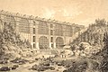
Engraving from the building around 1850

Memorial plaque for the establishment

The landscape at the Elstertal Bridge around 1900

Representation of the Elstertal Bridge in 1945

Restoration plaque

Detail of the bridge in 2008

Elstertal Bridge from below 2013


People involved
- Professor Johann Andreas Schubert (1808–1870, planner of the Göltzschtal bridge ) - design of the bridge and calculation of the statics
- Senior engineer Robert Wilke (1804–1889) - implementation planning and site management
- Engineer Hermann Kell (1820–1889) - site manager
- up to 899 workers
Further technical data
| Number of bricks | 12,323,000 |
|---|---|
| Volume brick masonry | 31,237 m³ |
| Volume of stone masonry | 21,579 m³ |
literature
- Peter Beyer : The construction of the Göltzschtal- and Elstertalbrücke 1846 to 1851. Its relations to the productive forces and the environment in the Saxon Vogtland and its neighboring areas. In: Sächsische Heimatblätter . Vol. 30, No. 1, 1984, pp. 1-16
- Peter Beyer: The creation of the railway connection between Saxony-Bavaria with the large bridges in the Göltzsch- and Elstertal 1836-1851. In: Sächsische Heimatblätter. Vol. 47, Issue 3, 2001, pp. 139-155.
Individual evidence
- ^ Sächsisches Staatsarchiv-Bergarchiv Freiberg, 40169 No. 721 Fischer Fundgrube in the Röttisleithe