
Elstertrebnitz
| coat of arms | Germany map | |
|---|---|---|

|
Coordinates: 51 ° 9 ' N , 12 ° 14' E |
|
| Basic data | ||
| State : | Saxony | |
| County : | Leipzig | |
| Management Community : | Pegau | |
| Height : | 129 m above sea level NHN | |
| Area : | 11.66 km 2 | |
| Residents: | 1291 (Dec. 31, 2019) | |
| Population density : | 111 inhabitants per km 2 | |
| Postal code : | 04523 | |
| Area code : | 034296 | |
| License plate : | L , BNA, GHA, GRM, MTL, WUR | |
| Community key : | 14 7 29 100 | |
| LOCODE : | DE EEZ | |
| Community structure: | 7 districts | |
| Association administration address: | Markt 1 04523 Pegau |
|
| Website : | ||
| Mayor : | David Zühlke ( CDU ) | |
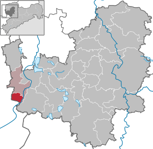
| Location of the municipality of Elstertrebnitz in the Leipzig district | ||
  |
||

Elstertrebnitz is a south-west of Leipzig and Pegau , west of Borna , northeast of Zeitz and east of Weissenfels located community in Saxony . The municipality has been administered since 2002 by the Pegau administrative community . Elstertrebnitz is characterized by its agriculturally used areas and its proximity to the Leipzig lake landscape . The municipality bordering on Saxony-Anhalt is one of the longest street villages in the Free State. The history of the place extends over 950 years.
geography
Geographical location


The municipality of Elstertrebnitz is located in the south of the Leipzig lowland bay approx. 15 km northeast of Zeitz and approx. 30 km southwest of Leipzig in the triangle (Saxony - Saxony-Anhalt - Thuringia ) and borders directly on the state border with Saxony-Anhalt. To the east of the community is the newly developed Leipziger Neuseenland , while the village is bounded by the Profen open-cast mine in the northwest . The B 2 and the Leipzig – Zeitz railway line run through Elstertrebnitz. In the south-east, the White Elster flows through a former meadow landscape, which is characterized by extensive agricultural and forest areas. Branching off before the Saxon state border, the Profener Elstermühlgraben runs through the individual districts of the municipality.
The Elstermühlgraben drove the mills from Elstertrebnitz to Großzschocher partially until the 20th century. Today only a few mills are still in operation. The Mühlgraben was primarily used by the village population as a bathing area and as a source of water for the used washing water. The Pegauer Bad, which is right next to the Elstermühlgraben, cleaned and used the water for its system. But the Mühlgraben was also used as a "transport route" for a wide variety of purposes. For example, the old raft ditch , which in earlier times transported wood from the Vogtland and in the 20th century the wastewater from the nearby Profen opencast mine, led to the artificial Elster junction. The drinking water for the local population was therefore not taken from the Mühlgraben, but mainly drawn from the local (and private) wells . In the GDR era, household wastewater (treated and untreated) was discharged into the Elstermühlgraben. After the political change in 1989, Elstertrebnitz got a modern sewage system and the turbines of some mills were used to generate electricity.
geology
During the Carboniferous - Permian a rocky landscape made was in the area around Elstertrebnitz greywacke with existing slate underground lowlands. Sea flooding resulted in deposits of algae reefs (up to approx. 40 m high) and, in the lowlands, sediments of gypsum , anhydrites and salts, the so-called Zechstein . Red sandstone and Tertiary sediments were deposited over the layers . In the Tertiary, the whole area was covered with lignite bogs, and the sediments of the Zechstein Sea leached out. Due to the lowering of the bog, which resulted in increased peat formation , a mighty lignite underfloor (50 m thick) was able to form in the area of today's Profen opencast mine . Also embedded in the sediments of the Tertiary is an almost 10 to 20 m thick lignite seam (upper seam) that extends over large areas of the Leipzig lowland bay. During the Ice Age until more recently, gravel and sediments were deposited, which shaped today's landscape.

The municipality of Elstertrebnitz is located on the western course of the White Elster , which has cut into the layers of the Ice Age deposits by shuttling back and forth. The valley floor of the White Elster near Elstertrebnitz is at an average height of 130 m above sea level. The seven districts of Elstertrebnitz are mostly 5 m higher on a terrace. This terrace was graveled during the second ice age and later covered with further debris. During the third ice age, fertile loess and damp black earth were deposited over it. To the east, the Elsterterrasse runs on a 10 to 15 m high slope, which consists of mica sand from the Oligocene , pre-glacial Elster gravel and boulder clay . The yellow to reddish brown alluvial clay of the Elsteraue comes from the annual flood sediments and forms layers between 1.70 and 4.50 m thick. On this fertile floodplain, the landscape developed into a distinctive floodplain forest with many oaks until the end of the 19th century . The Elster was straightened in the 1930s in order to prevent the floodplain landscape and the neighboring villages from being flooded every year. The problem was only solved by building dams on the upper reaches of the Elster.
Neighboring communities
The town of Pegau in the north, the town of Groitzsch in the northeast, the town of Elsteraue in the south and the town of Hohenmölsen in the west border the town of Elstertrebnitz . The municipalities of Elstertrebnitz and Hohenmölsen are geographically separated by the Profen opencast mine.
Local breakdown and land use
The municipality of Elstertrebnitz is divided into seven districts. In the following they are named in the geographical order from north to south:

- Eulau (district B)
- Elstertrebnitz (district A)
- Tannewitz (district C)
- Trautzschen (district D)
- Greitschütz (district E)
- Costewitz (district F)
- Oderwitz (district G)
Elstertrebnitz has an area of 1166 ha , of which 612 ha (52.5%) are used for agriculture. 388 hectares, i.e. a third of the community area, is designated as mining land, including land that is used, for example, for lignite extraction (e). Water and forest areas are given as 74 ha (1.1% and 5.2%). Another 86 hectares (7.4%) are classified under the settlement and transport category. The use of the settlement and traffic area is divided into 48 hectares (4.1%) of buildings and open spaces and 2 hectares (0.2%) of recreational areas. The cemeteries in Elstertrebnitz take up an area of 1 ha (0.1%). The traffic area of 36 ha (3.1%) includes roads and paths, which alone make up an area of 27 ha. The Elstertrebnitz settlement area is mainly located along the Elstermühlgraben; there are no built-up areas west of the railway and east of the B2.
climate
The climate of Elstertrebnitz is mainly influenced by moderate weather conditions. In 2006 the main wind directions were split between NE and SW, with average wind speeds of around 3 km / h. The maximum wind speeds were between 10 and 50 km / h. The proximity to the Harz Mountains and the Ore Mountains determine the amount of precipitation, especially from the south and west wind direction. The temperatures are between 35 ° C (in July) and −12 ° C (in January). At 1000 W / m², solar irradiation is quite high in a national comparison; this peak value is reached from April to July.
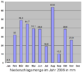
Precipitation 2006 according to the Leipzig-Holzhausen weather station

Temperature 2006 according to the Leipzig-Holzhausen weather station

Average wind speed 2006 according to the Leipzig-Holzhausen weather station


history
Settlement in prehistory and early history
The oldest settlement in today's municipality comes from the band ceramic culture . A rubbish pit and other remains of the settlement were documented during the excavation of a ceramic burial ground that was cut and partially destroyed during the construction of the sports field in the Trautzschen district in 1936. A stool grave contained a female skeleton and two cord ceramic vessels (1800–750 BC). After the excavation, it came to the Grassi Museum in Leipzig . A total of 50 graves were found. In addition, 15 vessels from the Iron Age (750 BC) were found, but destroyed by ignorance.
A splendid ax found in the district of Greitschütz from the Cordial Ceramic Period (around 2500 BC) is kept in the State Museum of Prehistory in Dresden and will probably be on display in the future in the House of Archeology and History of Saxony in Chemnitz.
The Germanic tribe of the Hermunduren settled here in the first centuries after Christ. The found bracteate , which is now in the Statens historiska museum in Stockholm, dates from around 500 AD . In the course of the migration of peoples , the majority of the people left their settlement areas, into which Slavic groups immigrated from the end of the 6th century and settled in small hamlet-like settlements. The Slavs, who formed the Sorbian tribe , were incorporated into the East Franconian - German Empire under King Heinrich I (around 920) and his son Otto at the latest in the first half of the 10th century .
Development of the villages in the course of the country development


The upper villages of Elstertrebnitz have almost all Slavic names. They were probably created jointly by Slavic farmers and farmers who immigrated from the Franconian, Saxon and Thuringian old settlements west of the Saale and Elbe, who were moved to the Elster and Elster area by Count Wiprecht von Groitzsch , among others, in the period around 1100 and in the early 12th century Pleiße were recruited. The area was in the catchment area of the Pegau monastery . Its monks had today's Elstermühlgraben built, which formed the basis for the town's mills. The tympanum relief from the end of the 12th century is probably "one of the earliest artistic evidence in Saxony". The relief, formerly from the Elstertrebnitz St. Martin's Church, is now in the Albrechtsburg Museum ( Meißen ), a copy can be seen in the Pegau Museum .
First documentary mentions
It could be possible that Eulau is mentioned for the first time as Ylowe in 1268 in a document of the Margrave Dietrich von Landsberg printed in the deed book of the Hochstift Merseburg . There, however, he is associated with Ihlewitz near Gerbstedt . The place name probably comes from ilow ( il for "loam", "clay") and changed since 1482 from Ylo to Ilaw and Eylaw to Eulau .
Elstertrebnitz , the oldest of the seven districts, was first mentioned in the written sources in 1039. The old Wendish name Trjêbnica means place of clearing; Elster or Alster can come from flowing . Called Trebnitz since 1290, the place name changed via Trebicz (1468), Trebenitz (1548) and Elster Trebenitz (1590) to today's Elstertrebnitz.
Tannewitz was founded in 1350 in Lehnbuch of Frederick the austerities as Tannewicz mentioned and his name should have received from the family of the Tannova.
Trautzschen was first mentioned in the Codex diplomaticus Saxoniae in 1209 . The oldest "document" of the place is an oil painting depicting the church patron Heinrich Puster as the court lord. On this picture is the lettering:
- “In the cross of our Lord Jesus Christ, through whom the world was crucified to me and I to the world, is my glory and my ransom. Heinrich Puster auf Drauschen, the very illustrious elector, the chairman of the Naumburg church, Deckan the Meißner and elder of the Martinsburg [Merseburg] church and provost of Zeitz ” .
In Profen's chronicle it can be read that in 1235 the Druziner (Trautzschen) chapel was split off from the Profens church and the right of patronage was transferred to the knight Arnold von Druzin . The place name changed from Trautschen to Trautzschen until 1857.
Like Tannewitz, the district of Greitschütz was also mentioned as Grutschitcz in 1350 in Friedrich the Strict's feudal book. The interpretation of the place name ranges from the derivation of personal names ( Kricice , Kric or the Kric clan ) to the derivatives of Grutschütz or Greschütz ("hump" or "hill"). From Grutschitcz (1350) was Grawczitz (1522), Greutzschietz (1548) and Greizschitz (1690).
Costewitz was named as Kostitz in the historical register of Saxony in 1320 . The name probably comes from the Slavic Chostic ("forest" or "thicket") and changed via Kostewitz (1590) to Costewitz (from 1766).
In 1346 Oderwitz was mentioned for the first time in a document that is now in the Dresden Main State Archives . In the past, the place was also known as Oderwitez (1469) and Kleinoderwitz .
Historical events


On April 22, 1348, Johann von Trautzschen (Drutzschen) conquered and destroyed parts of the robber knight's castle Rudelsburg as Capitaneus over the angry Naumburg citizens . For the first time in history a powder gun was used.
In 1545 the Pegau council bought three mills in the upper villages - the mill in the Elstertrebnitz district and the grain mills in Greitschütz and Oderwitz. In 1670 an oil mill was mentioned in the Elstertrebnitz district, which can also be found on a map of the Pegau office from 1757, but no longer exists today.
During the Thirty Years War in 1632, the Costewitz district was sacked by imperial troops. In the same year the plague broke out.
From the middle of the 17th century to the middle of the 19th century, the patrimonial courts were located at the estates in Elstertrebnitz (1763–1855), Costewitz (1661–1891), Trautzschen (1638–1873) and Oderwitz (1763–1861).
On May 3, 1813, Napoleon rode through the districts of Elstertrebnitz and Trautzschen. He had a glass of milk brought to him from the Trautzschen manor, which was handed to him by the then private tutor of the Baron von Apel auf Trautzschen. Due to the newly established state borders in the Congress of Vienna (1814/15), Saxony had to cede a large part of its lands to Prussia . On June 7, 1815 Profen became Prussian, the place Oderwitz remained Saxon. Due to this demarcation, you can still see a royal Saxon border crossing stone next to a bell-shaped, royal Prussian half- milestone on the old trunk road 2 . Not far from the former border is the so-called road money collector's house, a kind of customs house with a customs barrier.
The Royal Saxon Military Association KSMV 7 Oberdörfer Trautzschen was founded in 1871 and joined the Royal Saxon Military Association in 1878. A membership of 120 people is documented from 1906.
In 1900 there were 60 farmhouses in Elstertrebnitz, which cultivated a total area of around 1000 hectares. The four manors accounted for 70% of this usable area.
In 1912 Dr. Kirsche the seed breeding company Dr. Kirsche-Pfiffelbach was founded in the old manor in the Trautzschen district. The ears of winter rye depicted on a prospectus of the seed breeding company from 1919 could have served as a model for the design of the coat of arms. Known varieties are for example the beet varieties cherry Kolloß and cherry-Ideal , the Lobe Combinatorial feed carrot , the seed of cocksfoot and reed canary grass . His cereal breeds include ring rye , steel rye and thick-headed wheat .
On April 13, 1945 the 777th Panzer Battalion of the US Army reached Elstertrebnitz and left the town on April 16 to advance to Schweinfurth. In July 1945 it was occupied by the Red Army.
After the Second World War (in October 1945) a school and public meal for the needy was set up in the “Gasthof Greitschütz”. Through the land reform in 1946 the manors were expropriated and given to new farmers. Each new farmer received 5 hectares of land.
From 1950 onwards, the village tradition included the cinema presentations by the “ Landfilm ” in the “Gasthof Greitschütz”. On June 1, 1954, the foundation stone was laid for the first new school building in the GDR after the Second World War. The new school building was inaugurated on September 4, 1955. The iron mill , which had been in operation in Oderwitz since 1915, was expropriated in 1960 after the owners had left the GDR and declared as state-owned. In the same year the LPG Elstertal was founded. Its 21 members cultivate 144 hectares. In 1964 the LPG Elstertal had to close because the agricultural area was reduced to 27 hectares by the open-cast mine. The members then joined the LPG Auligk . A crèche was set up in a former leather clothing factory in 1962. In 1969 the school in Elstertrebnitz was expanded into a ten-class polytechnic high school . The two mills in the districts of Elstertrebnitz and Costewitz were nationalized in 1970. In 1984 Elstertrebnitz received the badge of honor from the National Council of the National Front for his initiative “ Beautiful Our Cities and Towns ” . In 1985 the bakery in Greitschütz was taken over by LPG Auligk.
Long-term plans for lignite mining by the GDR Ministry of Coal and Energy provided for the development status of the "Office for Mining Affairs Leipzig" from 1987 to excavate the Elstertrebnitz community in the so-called future development field "Elsteraue-Süd" around 2025. The political change of 1989/90 and the resulting economic changes made these provisions superfluous with regard to the massive loss of importance of lignite and its various uses.
The first village festival after the political change was celebrated in 1990.
Documented disasters
In 1632 the Costewitz district was looted as a result of the Thirty Years' War, and the plague broke out in the village . The large documented fires include those from the Trautzschen district that raged in 1588, 1645, 1688, 1745, 1867 and 1874. The Trautzschner parish archives were destroyed in 1745 and the manor burned down almost completely in 1874. One of the great famines was that of 1771. The flood was only perceived as a catastrophe when the Elster was straightened, as flooding in the floodplains was common up until then. The flood of 1953, the year in which the B2 was led around Elstertrebnitz, is considered to be the “flood of the century”. The water was one meter above the new building and is said to have stood as far as the city of Zeitz (15 km away).
Incorporations
Since 1818, according to the regulations of the Congress of Vienna, parcels of the districts Costewitz, Elstertrebnitz, Greitschütz, Oderwitz and Tannewitz belong to Prussia . During the German War of 1866, the Prussians briefly occupied the upper villages.
In 1934 the districts of Costewitz, Eulau, Greitschütz, Oderwitz, Trautzschen, Tannewitz and Elstertrebnitz were merged through an administrative reform to form the common place Elstertrebnitz. In 1945/46 Elstertrebnitz was assigned to the municipality of Pegau, but it was independent again in 1947. Since 2002 there has been a joint municipal administration with the city of Pegau, to which the municipality of Kitzen previously also belonged (incorporated into Pegau on January 1, 2012).
Population development


|
|
Data source from 1990: State Statistical Office Saxony
religion
19% of the population are Protestant, 3% Catholic. Protestant church services take place in the Luther Church in Costewitz, which belongs to the parish Pegau in the parish of Leipziger Land of the Evangelical Lutheran Church of Saxony . The Catholics are assigned to the parish of St. Bonifatius (Leipzig) , the next branch church of which is St. Hedwig (Pegau) .
politics

Municipal council
(+ 6.2 % p )
(-6.2 % p )
The municipal council consisted of twelve elected members in the 2004–2009 legislative period, eight of which belonged to the CDU and 4 to the Free Voting Association (FWG). Of the twelve members, three were women and nine were men. In the municipal council election on June 7, 2009, the CDU received 57.0% and the FWE 43.0% of the votes. The turnout was 54.1%. In the municipal council election on May 25, 2014, the CDU received 70.9% (9 seats) and the FWE 29.1% (3 seats) of the vote.
Since the municipal council election on May 26, 2019 , the 12 seats of the municipal council have been distributed among the individual groups as follows:
- CDU : 10 seats
- Free voters Elstertrebnitz (FWE): 2 seats
The aim of the community policy is to maintain the ability of the local community to act and to improve the living conditions of the local population. The choice of the type of administration and the optimization of the municipal budget play a decisive role here. When making new investments, it is important to keep new debt low. Current investments (as of 2006) include the renewal of the road system with a simultaneous connection to the sewage system. Goals already achieved include: a. the new construction of the four bridges, the connection of the community to the natural gas network, the modernization of the day-care center, the construction of a new fire station and the renewal of the fire service technology.
Parts of the Elstertrebnitz municipality are threatened by floods in irregular sections. For flood protection, a report with suitable recommendations was prepared by the state dam administration of the Free State of Saxony.
mayor
Mayors since 1947 were Alfred Legler, Herbert Riemer, Paul Werner, Kurt Zocher, Gerhard Hanke, Walter Schlag, Willi Engelmann, Gert Döring and Klaus Sommer. The current mayor is David Zühlke, who was elected in June 2015 with 94.8% of the vote.
Coat of arms and flag

The first (officially unconfirmed) coat of arms of the municipality of Elstertrebnitz existed in the first years after the fall of the Wall until 1994 and represented a mill wheel, the Elstermühlgraben and an ear of wheat. In 1995 the coat of arms was redesigned and officially confirmed. It shows three black mill wheels and three golden ears of wheat tied into a sheaf . The main colors of the coat of arms are silver and green, whereby green symbolizes the Elsteraue and the wavy division of the coat of arms the White Elster. The ears of corn describe the agricultural character of Elstertrebnitz, and the three mill wheels stand for the three mills of the town. The old coat of arms of the municipality was designed more simply and showed a mill wheel, the Elstermühlgraben and an ear of wheat as a symbol of the agricultural Elstertrebnitz.
The Elstertrebnitz flag is based on the colors of the Free State of Saxony . The flag is white, flanked in green and is decorated with the local coat of arms.
Community partnerships
In the 1990s, community representatives from Elstertrebnitz and the community of Baltmannsweiler ( Baden-Württemberg ) met to discuss structures, common ground and possible cooperation. Relations between the two communities did not deepen during the beginning of the 21st century.
Culture and sights


Buildings
The St. Martin's Church is located in the Elstertrebnitz district. The Marienkapelle was first mentioned in the sources of Elstertrebnitz in 1290. In 1460, the artist Nikolaus Eisenberg designed the church bell for the Romanesque church, which was artfully decorated with carved bell drawings - this bell was saved from melting down by a state monument conservationist in 1917 , it can be seen in the Dresden Museum of Decorative Arts . In the same year the church was named after Saint Martin . The tower, construction of which began in 1483, was demolished inside in 1745 to use an organ . After the complete demolition in 1840 and the rebuilding of the Elstertrebnitzer church, it was consecrated on February 6, 1842. After a fire in the 1980s, the church could no longer be used as a place of worship. In 1999 the listed Kreutzbach organ from 1841 was transferred from the St. Martin's Church to the Auenkirche in Markkleeberg and could thus be saved from deterioration. The church building was sold in 2000 and gradually renovated, sold again in 2018 and can now be booked for events as the Kulturkirche Sachsen .
The Kreuzkirche of Trautzschen was first mentioned as Trautzschner Chapel around 1235. At that time it was separated from the Profen mother church by Zeitz Bishop Engelhard and given to the knight Arnold von Druzin. A bell was donated by Hans von Draschwitz in 1465 . In 1475 Johann von Draschwitz had the village church rebuilt in Gothic style. The Trautzschner church received the status of a parish church in 1540 . In 1745 the Trautzschner church archive was destroyed by fire, and in the same year the church received a high pulpit altar . After a renovation in 1775, a new organ was installed. In 1843 it also received a Kreutzbach organ. At the end of the 18th century, letters from the Trautzschen rectory were given a green and white embossed seal mark. The church has not been used since the 1980s because it could not be renovated for cost reasons and it continued to deteriorate over time. The sandstone wall grave of Burgold Puster, who died in 1567, is remarkable.
The Elstertrebnitz Luther Church in the Costewitz district was founded as a small chapel towards the end of the 12th century. As early as 1467, it received its current appearance as an early Gothic church with baroque furnishings. A small winged altar was built in around 1525 . The Costewitz church received the status of a parochial church in 1560. The looting by the imperial troops in 1632 during the Thirty Years War fell victim to the church and village (Costewitz), a silver gilded wine jug and a box of host were lost. In 1695 silver altarpieces and theological books were donated to the church. The parish bought a used organ from Kayna in 1732. Construction work followed, such as the renovation of the tower in 1786 and the lengthening of the nave in 1801. In 1836 a Kreuzbach organ was donated to the church by the Oderwitz mill owner. The bells from Apolda were installed in 1870. The Elstertrebnitz Luther Church in Costewitz is now part of the Pegau parish and is used for Sunday services.
The iron mill in the Oderwitz district is now a technical monument. The conversion of a former grain mill took place in 1915. This resulted in an iron mill whose production process is unique in Germany. To produce iron powder, 1 m long, 80 mm wide and 40 mm thick iron rods were rubbed together for six weeks with the help of turbines. The resulting iron powder was used for sparklers , fireworks , spark plugs , magnetic boards , filaments , television tubes and medicines . After the mill became public property in 1960, it was returned to its former owners in 1990. The iron powder production facility was discontinued in 1992. After the dilapidated building was taken over by the new owners in late summer 2007, the repair of the outer shell began and the hydropower plant was converted to generate renewable energy .
A museum for self-playing mechanical musical instruments is housed in the west wing of the building. There is also the double portrait of the musicologist Dr. Werner König by the painter Elmar Worgull from 1973.
In addition to the manors in the districts of Elstertrebnitz, Oderwitz (first mentioned in 1469), Tannewitz and Trautzschen, the manor in Costewitz, which was described around 1850 with the following words:
- “In the beautiful, dense row of villages, which stretches up from Pegau to the southwest and which everywhere certifies a blessing that will seldom make a whole area happy again, the hamlet of Kostewitz or Costowitz with its 172 inhabitants is located 1½ hours from the city of Pegau. Just as pleasant and beautiful as the whole village is the manor of this place with its beautiful gardens, fields and meadows. The buildings of the estate enhance the sight of the place with their tasteful layout and beauty inside. The manor itself was otherwise called the Zeiselhof ” .
Gut Oderwitz had its own brewery from 1880.
The former baroque mansion in the Greitschütz district, which was built around 1580 and can now boast a renaissance portal, is another testament to the stately architectural style .
In addition to half-timbered and container houses, the field stone houses show another ancient architectural style in Elstertrebnitz. In terms of construction, the houses were built entirely from field stones, which are held together by clay jointing.
On the old trunk road 2 (F 2) , from Elstertrebnitz in the direction of Beersdorf , a royal-Saxon border crossing stone and a royal-Prussian half- milestone (big bell) mark the former border between the Kingdom of Saxony and the Kingdom of Prussia from 1815 , today the federal state border between Saxony and Saxony-Anhalt .
Green spaces and recreation
The open-cast mining landscape in the northwest of the municipality is also worth seeing. The former raft ditch was rebuilt on the recultivated overburden area . There is also a lookout point and the memorial for the town of Stöntzsch, which was demolished in 1965–66 .
The municipality of Elstertrebnitz took part in the 7th Saxon state competition “Our village has a future” in 2007/2008 and came in second. Since April 2008 there have been concrete plans to recultivate the opencast mining landscape around Elstertrebnitz. A concept is being worked on that will create new agricultural and lake areas.
Sport and tourism
- Elstertrebnitz lies on the Elsterradweg
- Elstertrebnitz lies at the intersection of the regional riding trail that leads from Elstertrebnitz to Groitzsch (Kleinprießligk district) and the long-distance riding trail that runs along the Elster and Zwenkauer See lakes.
- The Tractor Elstertrebnitz football team was the first tractor team in the GDR .
- During the GDR era, Günter Möse (Olympic champion in weightlifting in 2003 in Melbourne and world record holder in snatching at 90.5 kg) successfully trained the Elstertrebnitz youth for regional weightlifting championships.
- Today the members of the sports club SV Elstertrebnitz e. V. in the disciplines of bowling, soccer and volleyball.
- Angelsportverein Elstertrebnitz eV
Regular events
The Gasthof Greitschütz regularly organizes concerts and festivals.
Economy and Infrastructure
traffic

Elstertrebnitz maintains an extensive road and path network that covers a total area of 36 hectares. The village street alone is 7 km long, making Elstertrebnitz one of the longest street villages in Saxony; there are also streets and paths that are managed by MIBRAG . The federal road 2 leads east past Elstertrebnitz. With approx. 1000 km it is the longest and one of the oldest federal highways in Germany. Between Gera and Leipzig, it followed the course of the historic "Reichsstraße" Via Imperii . In 1953 the B 2, formerly located west of Elstertrebnitz, was relocated and passed east of the village and town of Pegau. The reason for the diversion was the devastation of parts of the community by the Profen opencast mine.
Deep sewer ditches lined the streets of Elstertrebnitz well into the 20th century. These disappeared at the beginning of the 20th century with the introduction of septic tanks and drainage into the Mühlgraben. Although some manors already had their own water supply system ( drinking water ), around 1950 the water supply was run through Elstertrebnitz. This became necessary because the groundwater sank steadily due to the approaching opencast mining area. In 1997 the community was included in the community development program of the Free State of Saxony. Therefore, the sewage supply could be expanded piece by piece and the streets renewed until 2005/06.
Elstertrebnitz has four bridges that lead over the Elstermühlgraben and connect the community with the B 2. These could be renewed since the turning point . Once before, in 1929 the Trautzschner Bridge was demolished and replaced by a reinforced concrete bridge. As one of the first communities in the region, Elstertrebnitz was connected to the public natural gas supply after the GDR era . In 1996, the old raft ditch west of Elstertrebnitz was renewed by MIBRAG through recultivation work.
Two bus lines connect the cities of Leipzig, Zwenkau , Groitzsch, Pegau and Zeitz with the municipality of Elstertrebnitz from Monday to Friday . From the Saxon side, LeoBus runs on line 124 from Zwenkau via Groitzsch and Pegau to Elstertrebnitz. The bus service from Zeitz to Elstertrebnitz is operated by the PVG Burgenlandkreis on line 850 . The proximity to the Pegau train station also ensures good train connections to the cities of Zeitz, Gera and Leipzig, which can be reached within 30 minutes. The nearest airports are Leipzig-Altenburg Airport and the major airport Halle-Leipzig .
Established businesses

Until the beginning of the 20th century there were mainly smallholder businesses. The surrounding trade and industry concentrated almost exclusively on this occupational group. So one could find blacksmiths and cartwright shops in Elstertrebnitz . There were also inns and retailers. The brick kiln , located in the district of Eulau, got its clay from the surrounding clay pits , which were sometimes in the floodplain of the Elster. The largest turnover, however, had the goods, manors and mills of Elstertrebnitz.
Due to the nationalization of land by the GDR regime, only smaller craft businesses were in private hands. In this way, rather unprofitable branches of business such as bakery , hairdressing and retail ( consumption ) were able to hold up. The properties of the mills and manors were converted into state- owned enterprises (VEB) and agricultural production cooperatives (LPG). The work in the cooperatives determined the life of the village population.
After the political change in 1989/90, the trade and industry developed. Today (as of 2006) you can find larger companies in Elstertrebnitz such as coal and fuel trading, scrap and recyclable materials trading, inns and pensions . In addition, there are a number of smaller companies such as media and sound design studios, electrical, painting and construction companies, interior decorators, veterinarians, car workshops, small agricultural businesses and various services and small businesses.
The currently (as of 2015) largest company based in Elstertrebnitz is the Schrott Wetzel company with around 200 employees across Europe.
Public facilities
A public library is available to the citizens of the community.
In 1951, the Borna kindergarten preschool education with a maximum of 72 places was set up in the administration building of the old seed nursery (Trautzschen district) . Today (as of 2006) the kindergarten is called Knirpsenland and is equipped with modern technology. In March 1962, a day nursery ( Kinderland ) with 52 beds was built in a former leather clothing factory in the district of Eulau . However, after 1990 it was closed.
education


Schoolrooms existed near local churches at the end of the 16th century. As early as 1580, instruction was given in the sextonry in the Costewitz district. It is also documented that a school with a teacher's apartment was built in Trautzschen in 1839, and that a second classroom was added in 1888. Up until the beginning of the 19th century, school fees had to be paid, the price being based on whether the children should learn to read, write or even learn to count. After the Saxon Elementary Schools Act was passed on June 6, 1835, the communities were required to raise funds and maintenance for schools and teachers. This did not succeed immediately in Elstertrebnitz. Abuses are documented until 1904. The reason for this was the lack of interest of the manor owners, as they let their children be privately taught.
After the end of the war, a makeshift schooling began in Elstertrebnitz in 1945. Almost at the same time a school and public meal was set up in the Greitschütz Inn. On June 1, 1954, the foundation stone for a new school building was laid, which was inaugurated in September of the following year. In 1965 the school was named " Bertolt Brecht School"; In 1969 it was expanded to become a ten-year polytechnic high school .
After 1990 the school was brought into line with the system of the Federal Republic of Germany. In the following years, also due to the demographic development, it was converted into a primary school in combination with a school to promote learning . Today (as of 2006) the building only houses the school for learning support. In 2003, the children of the school won first place in the Youth Environment Prize 2003 .
Personalities
Born in Elstertrebnitz
- Heinrich Wilhelm von Huth (1717–1806), Danish general and knight of the Elephant Order
- Karl-Heinz Bringer (1908–1999), engineer and missile specialist
- Herbert Steinmetz (1908–1986), actor
- Werner Kamenik (actually Gustav Werner Steinmetz) (1910–1993), actor
Lived in Elstertrebnitz
- Johannes Hohlfeld (1888–1950), German genealogist and historian
Associated with Elstertrebnitz
- Johannes Schader (1589–1633), heir and court lord through temporary possession of the Elstertrebnitz manor with the associated villages of Elstertrebnitz and Eula
Others
- The village of Elstertrebnitz is mentioned in the "German legal dictionary" to explain the word dog grain .
literature
- Pro Leipzig eV (Ed.): In the Elsterland between Zwenkau, Groitzsch and Pegau. In cooperation with the cities of Zwenkau, Groitzsch and Pegau ed. v. Pro Leipzig eV, Leipzig 2002. ISBN 3-936508-92-5 .
- Werner Höhne: Elstertrebnitz - 1039–1989 , Elstertrebnitz 1989.
- Richard Steche : Elstertrebnitz. In: Descriptive representation of the older architectural and art monuments of the Kingdom of Saxony. 15. Issue: Amtshauptmannschaft Borna . CC Meinhold, Dresden 1891, p. 19.
Web links
- Elstertrebnitz in the Digital Historical Directory of Saxony
- Page from Elstertrebnitz
Individual evidence
- ↑ Population of the Free State of Saxony by municipalities on December 31, 2019 ( help on this ).
- ↑ Cultural and historical walks through the Elsteraue . In: Heimatgeschichtliche Blätter des Kreis Borna, ed. from the Council of the District, Department of Culture and Culture Association of the GDR, Borna District Executive of the Society for Local History; Issue 2, 1989
- ↑ Weather station Leipzig-Holzhausen ( Memento from February 13, 2009 in the Internet Archive )
- ↑ www.wetter.com
- ↑ M. Axboe / U. Clavadetscher / K. Düwel / K. Hauck / L. v. Padberg: The gold bracteates of the migration period. Iconographic catalog . Munich: Fink 1985–1989
- ↑ cf. on this Die Ephorie Borna; Place of publication: Leipzig; Publication year: 1903; Signature: Hist.Sax.L.48.b-3 and Die Inspectionen: Borna und Pegau; Place of publication: Dresden; Year of publication: 1841
- ↑ a b c d e Pro Leipzig eV (ed.): In the Elsterland between Zwenkau, Groitzsch and Pegau. In cooperation with the cities of Zwenkau, Groitzsch and Pegau ed. v. Pro Leipzig e. V., Leipzig 2002
- ↑ P. Kehr (edit.): Document book of the Hochstift Merseburg, 1st part (962-1357) , Halle, 1899 (= historical sources of the province of Saxony and neighboring areas, 36), p. 273.
- ↑ Hey, The Slavic Settlements in the Kingdom of Saxony . 1893
- ^ Hermann Schlegel, handwritten notes about Trautzschen
- ↑ P. Schenk, "New Saxon Atlas" 1757
- ↑ Summary of the Holdings of the State Archives, Leipzig ( Memento from June 13, 2007 in the Internet Archive )
- ^ "Pegauer Heimatblätter" No. 10 1931
- ↑ cf. see www.smvb.de/datenbank/ort-T.html
- ↑ cf. this report by the 777th Tank Battalion to march into Germany in 1945
- ↑ 2011 census
- ↑ Results of the 2019 municipal council election, accessed on April 10, 2019
- ↑ http://www.umwelt.sachsen.de/lfug/documents/32_01_Elstertrebnitz.pdf ( page no longer available , search in web archives ) Info: The link was automatically marked as defective. Please check the link according to the instructions and then remove this notice.
- ↑ https://www.statistik.sachsen.de/wpr_alt/pkg_s10_bmlr.prc_erg_bm?p_bz_bzid=BM151&p_ebene=GE&p_ort=14729100
- ↑ District Office Borna (ed.): District Borna - Freistaat Borna Verlag Ernst Gehring, Merseburg, 1992
- ↑ Frank Young, crest exposé, community Elstertrebnitz, Erfurt, 1995
- ↑ page 134 in: Rainer Thümmel; Roy Kress; Christian Schumann: When the bells went into the field ... - The destruction of Saxon bronze bells in the First World War. Evangelische Verlagsanstalt Leipzig 2017, ISBN 978-3-374-05203-5 - there the Eisenberg bell is also shown in postcard size.
- ↑ http://www.eventfabrik-leipzig.de/ - accessed on December 28, 2018
- ^ Richter, Gustav Ferdinand, Costewitz . In: The Inspections Borna and Pegau as the seventh division of Saxony's church gallery in Lief.
- ↑ Eisenmühle Oderwitz. (No longer available online.) In: Leipziger Neuseenland. Archived from the original on April 28, 2015 ; Retrieved September 12, 2012 . Info: The archive link was inserted automatically and has not yet been checked. Please check the original and archive link according to the instructions and then remove this notice.
- ^ Eisenmühle Oderwitz ( Memento from September 29, 2007 in the Internet Archive )
- ↑ Elstertrebnitz iron mill. (No longer available online.) In: ILE area Weisse Elster. Institute for Economic and Regional Development Leipzig, March 18, 2009, archived from the original on July 4, 2012 ; Retrieved September 12, 2012 . Info: The archive link was inserted automatically and has not yet been checked. Please check the original and archive link according to the instructions and then remove this notice.
- ↑ https://www.eisenmuehle.de/
- ↑ Compare this to the archive link ( memento of the original from December 25, 2011 in the Internet Archive ) Info: The archive link was inserted automatically and has not yet been checked. Please check the original and archive link according to the instructions and then remove this notice. in the Leipzig State Archives
- ↑ Compare this to the archive link ( memento of the original from December 25, 2011 in the Internet Archive ) Info: The archive link was inserted automatically and has not yet been checked. Please check the original and archive link according to the instructions and then remove this notice. in the Leipzig State Archives
- ↑ Compare this to the archive link ( memento of the original from December 25, 2011 in the Internet Archive ) Info: The archive link was inserted automatically and has not yet been checked. Please check the original and archive link according to the instructions and then remove this notice. in the Leipzig State Archives
- ↑ Compare this to the archive link ( memento of the original from December 25, 2011 in the Internet Archive ) Info: The archive link was inserted automatically and has not yet been checked. Please check the original and archive link according to the instructions and then remove this notice. in the Leipzig State Archives
- ↑ Poenicke, GA (Ed.): Album of the manors and castles in the Kingdom of Saxony based on nature, newly recorded by F. Heise, Architect , I. Section: Leipziger Kreis. Leipzig [around 1860]
- ↑ Archive link ( Memento of the original from October 17, 2004 in the Internet Archive ) Info: The archive link was inserted automatically and has not yet been checked. Please check the original and archive link according to the instructions and then remove this notice.
- ^ Schwarz, Alberto (Ed.): Schlösser um Leipzig , Leipzig 1993
- ↑ http://www.smul.sachsen.de/laendlicher_raum/55.htm
- ^ Official Journal of the city of Pegau and the municipality of Elstertrebnitz, online article on http://www.wittich.de/ from May 2, 2008 (edition 18/08)
- ↑ http://www.reitwanderfuehrer.de/sued_westl_route/tour_2.htm
- ↑ http://www.reitwanderfuehrer.de/sued_westl_route/tour_3.htm
- ↑ http://www.svelstertrebnitz.de.tl/ ( page no longer available , search in web archives ) Info: The link was automatically marked as defective. Please check the link according to the instructions and then remove this notice.
- ↑ cf. see www.kindergarten.elstertrebnitz.net ( memento of the original from February 20, 2012 in the Internet Archive ) Info: The archive link was inserted automatically and has not yet been checked. Please check the original and archive link according to the instructions and then remove this notice.
- ↑ http://www.rzuser.uni-heidelberg.de/~cd2/drw/e/hu/ndko/hundkorn.htm
- ↑ Document from a manuscript in the Saxon Main State Archives Dresden (HStArchDresden) 1691